![](/images/other/stat-length.png)
![Trail On foot Santa Catarina da Fonte do Bispo - Curral da Pedra - Photo](https://media.geolcdn.com/t/1900/400/ext.pjpeg?maxdim=2&url=https%3A%2F%2Fstatic1.geolcdn.com%2Fsiteimages%2Fupload%2Ffiles%2F1545311037marcheuse_200dpi.jpg)
Curral da Pedra
SityTrail - itinéraires balisés pédestres
Tous les sentiers balisés d’Europe GUIDE+
![Length](/images/other/stat-length.png)
Length
6.9 km
![Max alt](https://static1.geolcdn.com/siteimages/upload/files/1508320355ic_sort_altitude_max_24dp.png)
Max alt
236 m
![Uphill gradient](https://static1.geolcdn.com/siteimages/upload/files/1508320355ic_sort_den_pos_24dp.png)
Uphill gradient
181 m
![Km-Effort](/images/other/stat-length.png)
Km-Effort
9.3 km
![Min alt](https://static1.geolcdn.com/siteimages/upload/files/1508320355ic_sort_altitude_min_24dp.png)
Min alt
143 m
![Downhill gradient](https://static1.geolcdn.com/siteimages/upload/files/1508320355ic_sort_den_neg_24dp.png)
Downhill gradient
181 m
![Boucle](https://static1.geolcdn.com/siteimages/upload/files/16400158638029165_repeat_loop_refresh_sync_direction_icon.png)
Boucle
Yes
Signpost
Creation date :
2022-02-14 14:51:03.835
Updated on :
2022-02-14 14:51:03.835
![On foot](https://static1.geolcdn.com/sitytour/trail-icons/100.png)
2h06
Difficulty : Easy
![Scan this QR Code to open this trail in the SityTrail application](https://capi.geolives.com/qq0zvz2zws4bq2lad0pu/sitytour/trails/3109341/qr.png?size=200)
FREE GPS app for hiking
About
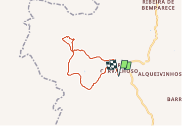
Trail On foot of 6.9 km to be discovered at Algarve, Faro, Santa Catarina da Fonte do Bispo. This trail is proposed by SityTrail - itinéraires balisés pédestres.
Description
Trail created by Município de Tavira.
Positioning
Country:
Portugal
Region :
Algarve
Department/Province :
Faro
Municipality :
Santa Catarina da Fonte do Bispo
Location:
Unknown
Start:(Dec)
Start:(UTM)
605636 ; 4114841 (29S) N.
Comments
Trails nearby
![Trail On foot Santa Catarina da Fonte do Bispo - Fonte de Águas de Tábuas - Photo](https://media.geolcdn.com/t/375/260/c7564bbe-d445-49ff-9882-e934dac2b818.jpeg&format=jpg&maxdim=2)
![On foot On foot](https://static1.geolcdn.com/sitytour/trail-icons/100.png)
Fonte de Águas de Tábuas
On foot
Easy
Santa Catarina da Fonte do Bispo,
Algarve,
Faro,
Portugal
![](/images/other/stat-length.png)
9.4 km | 13 km-effort
2h 56min
![](https://static1.geolcdn.com/siteimages/upload/files/16400158638029165_repeat_loop_refresh_sync_direction_icon.png)
Yes
![Trail On foot Santa Catarina da Fonte do Bispo - Telheiros do Barro - Photo](https://media.geolcdn.com/t/375/260/50f40b1d-6d85-4938-a433-caad5910f4ac.jpeg&format=jpg&maxdim=2)
![On foot On foot](https://static1.geolcdn.com/sitytour/trail-icons/100.png)
Telheiros do Barro
On foot
Easy
Santa Catarina da Fonte do Bispo,
Algarve,
Faro,
Portugal
![](/images/other/stat-length.png)
11.8 km | 15 km-effort
3h 25min
![](https://static1.geolcdn.com/siteimages/upload/files/16400158638029165_repeat_loop_refresh_sync_direction_icon.png)
Yes
![Trail On foot - Percurso Moinhos e Hortas - Photo](https://media.geolcdn.com/t/375/260/1643c608-7b4b-4e99-b624-4e3d9a417f9c.jpeg&format=jpg&maxdim=2)
![On foot On foot](https://static1.geolcdn.com/sitytour/trail-icons/100.png)
Percurso Moinhos e Hortas
On foot
Easy
(1)
,
Algarve,
Faro,
Portugal
![](/images/other/stat-length.png)
8.7 km | 11.5 km-effort
2h 36min
![](https://static1.geolcdn.com/siteimages/upload/files/16400158638029165_repeat_loop_refresh_sync_direction_icon.png)
Yes
![Trail On foot São Brás de Alportel - Caminhos e Encruzilhadas de Ir à Fonte - Photo](https://media.geolcdn.com/t/375/260/ext.jpg?maxdim=2&url=https%3A%2F%2Fstatic1.geolcdn.com%2Fsiteimages%2Fupload%2Ffiles%2F1545311037marcheuse_200dpi.jpg)
![On foot On foot](https://static1.geolcdn.com/sitytour/trail-icons/100.png)
Caminhos e Encruzilhadas de Ir à Fonte
On foot
Easy
São Brás de Alportel,
Algarve,
Faro,
Portugal
![](/images/other/stat-length.png)
8.5 km | 11.8 km-effort
2h 40min
![](https://static1.geolcdn.com/siteimages/upload/files/16400158638029165_repeat_loop_refresh_sync_direction_icon.png)
Yes
![Trail Walking Santa Catarina da Fonte do Bispo - Barrocais - Tavira - Photo](https://media.geolcdn.com/t/375/260/ext.jpg?maxdim=2&url=https%3A%2F%2Fstatic1.geolcdn.com%2Fsiteimages%2Fupload%2Ffiles%2F1553511878bg_sport_marche.png)
![Walking Walking](https://static1.geolcdn.com/sitytour/trail-icons/101.png)
Barrocais - Tavira
Walking
Easy
Santa Catarina da Fonte do Bispo,
Algarve,
Faro,
Portugal
![](/images/other/stat-length.png)
11.2 km | 13.4 km-effort
3h 4min
![](https://static1.geolcdn.com/siteimages/upload/files/16400158638029165_repeat_loop_refresh_sync_direction_icon.png)
No
![Trail Walking São Brás de Alportel - Sao Bras de Aportel - Photo](https://media.geolcdn.com/t/375/260/ext.jpg?maxdim=2&url=https%3A%2F%2Fstatic1.geolcdn.com%2Fsiteimages%2Fupload%2Ffiles%2F1553511878bg_sport_marche.png)
![Walking Walking](https://static1.geolcdn.com/sitytour/trail-icons/101.png)
Sao Bras de Aportel
Walking
Easy
São Brás de Alportel,
Algarve,
Faro,
Portugal
![](/images/other/stat-length.png)
8.7 km | 11.7 km-effort
2h 54min
![](https://static1.geolcdn.com/siteimages/upload/files/16400158638029165_repeat_loop_refresh_sync_direction_icon.png)
Yes