Trail On foot Mértola - As Margens do Guadiana - Photo

As Margens do Guadiana

Tous les sentiers balisés d’Europe GUIDE+

© OpenStreetMap contributors
Length
Length
5 km
Max alt
Max alt
145 m
Uphill gradient
Uphill gradient
110 m
Km-Effort
Km-Effort  
6.2 km
Min alt
Min alt
65 m
Downhill gradient
Downhill gradient
33 m
Boucle
Boucle
No
Signpost
Signpost
Creation date :
2022-02-14 14:48:44.291
Updated on :
2022-02-14 14:48:44.291

(0 Reviews)

On foot
On foot
1h24
Difficulty : Easy

Scan this QR Code to open this trail in the SityTrail application

FREE GPS app for hiking

Logo SityTrail SityTrail

IGN / Geographical institutes

Download SityTrail from the App Store Download SityTrail from Google Play

Logo SityTrail SityTrail World

The world is yours!

Download SityTrail from the App Store Download SityTrail from Google Play Download SityTrail on Huawei AppGallery

About

Trail On foot of 5 km to be discovered at Alentejo Region, Beja, Mértola. This trail is proposed by SityTrail - itinéraires balisés pédestres.

Description

Deixando para trás a povoação de Corte Gafo de Baixo, o percurso segue por uma paisagem de montado de azinho que dá lugar a densas manchas de matagal…

Website: https://visitmertola.pt/blog/item/pr2-as-margens-do-guadiana/

Elevation profile

Photos

Positioning

Country:
Portugal
Region :
Alentejo Region
Department/Province :
Beja
Municipality :
Mértola
Location:
Unknown
Start:(UTM)
618473 ; 4172615 (29S) N.

Trails nearby

Trail On foot Santana de Cambas - Rota do Minério - Photo
On foot
GUIDE+

On foot

Medium
Santana de Cambas, Alentejo Region, Beja, Portugal
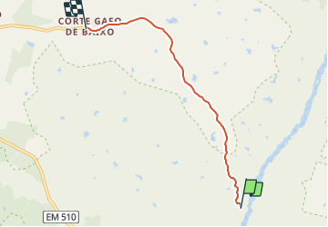
16.8 km | 20 km-effort
4h 37min
No
Trail On foot Mértola - Guadiana, o grande rio do Sul - Photo
On foot
GUIDE+

On foot

Easy
Mértola, Alentejo Region, Beja, Portugal
5.2 km | 6.2 km-effort
1h 24min
No
Trail Walking Mértola - pulo do lobo - Photo
Walking
lamartesch

Walking

Medium
Mértola, Alentejo Region, Beja, Portugal
6.7 km | 8.9 km-effort
2h 59min
Yes


Close
My subscriptions