![](/images/other/stat-length.png)
![Trail On foot Zevenaar - Rijnstrangenpad - Photo](https://media.geolcdn.com/t/1900/400/ext.pjpeg?maxdim=2&url=https%3A%2F%2Fmedia.geolcdn.com%2Ff%2F991f4728-fd23-4eff-8387-ce53e7cf18e5.jpeg)
Rijnstrangenpad
SityTrail - itinéraires balisés pédestres
Tous les sentiers balisés d’Europe PRO
![Length](/images/other/stat-length.png)
Length
14.3 km
![Max alt](https://static1.geolcdn.com/siteimages/upload/files/1508320355ic_sort_altitude_max_24dp.png)
Max alt
20 m
![Uphill gradient](https://static1.geolcdn.com/siteimages/upload/files/1508320355ic_sort_den_pos_24dp.png)
Uphill gradient
52 m
![Km-Effort](/images/other/stat-length.png)
Km-Effort
15 km
![Min alt](https://static1.geolcdn.com/siteimages/upload/files/1508320355ic_sort_altitude_min_24dp.png)
Min alt
8 m
![Downhill gradient](https://static1.geolcdn.com/siteimages/upload/files/1508320355ic_sort_den_neg_24dp.png)
Downhill gradient
52 m
![Boucle](https://static1.geolcdn.com/siteimages/upload/files/16400158638029165_repeat_loop_refresh_sync_direction_icon.png)
Boucle
Yes
Signpost
Creation date :
2022-02-14 14:48:29.654
Updated on :
2022-02-14 14:48:29.654
![On foot](https://static1.geolcdn.com/sitytour/trail-icons/100.png)
3h24
Difficulty : Easy
![Scan this QR Code to open this trail in the SityTrail application](https://capi.geolives.com/qq0zvz2zws4bq2lad0pu/sitytour/trails/3109292/qr.png?size=200)
FREE GPS app for hiking
About
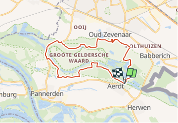
Trail On foot of 14.3 km to be discovered at Gelderland, Unknown, Zevenaar. This trail is proposed by SityTrail - itinéraires balisés pédestres.
Description
Trail created by https://klompenpaden.nl.
Symbol: paarse markering in de vorm van een klomp
Website: https://klompenpaden.nl/klompenpad/rijnstrangenpad/
Positioning
Country:
Netherlands
Region :
Gelderland
Department/Province :
Unknown
Municipality :
Zevenaar
Location:
Unknown
Start:(Dec)
Start:(UTM)
299858 ; 5753327 (32U) N.
Comments
Trails nearby
![Trail On foot Montferland - Liemers Knooppad 6 - Photo](https://media.geolcdn.com/t/375/260/ext.jpg?maxdim=2&url=https%3A%2F%2Fmedia.geolcdn.com%2Ff%2Fdev_b2ad50d1-04eb-423f-928a-8ae9dca5c1cf.jpeg)
![On foot On foot](https://static1.geolcdn.com/sitytour/trail-icons/100.png)
Liemers Knooppad 6
On foot
Easy
Montferland,
Gelderland,
Unknown,
Netherlands
![](/images/other/stat-length.png)
9.4 km | 10.4 km-effort
2h 21min
![](https://static1.geolcdn.com/siteimages/upload/files/16400158638029165_repeat_loop_refresh_sync_direction_icon.png)
No
![Trail Cycle Berg en Dal - Gelderland - Millingen Aan De Rijn - Photo](https://media.geolcdn.com/t/375/260/ext.jpg?maxdim=2&url=https%3A%2F%2Fstatic1.geolcdn.com%2Fsiteimages%2Fupload%2Ffiles%2F1524743154velo.jpg)
![Cycle Cycle](https://static1.geolcdn.com/sitytour/trail-icons/200.png)
Gelderland - Millingen Aan De Rijn
Cycle
Very easy
Berg en Dal,
Gelderland,
Unknown,
Netherlands
![](/images/other/stat-length.png)
31 km | 33 km-effort
Unknown
![](https://static1.geolcdn.com/siteimages/upload/files/16400158638029165_repeat_loop_refresh_sync_direction_icon.png)
Yes
![Trail Cycle Lingewaard - f-gelderland-linge - Photo](https://media.geolcdn.com/t/375/260/ext.jpg?maxdim=2&url=https%3A%2F%2Fstatic1.geolcdn.com%2Fsiteimages%2Fupload%2Ffiles%2F1524743154velo.jpg)
![Cycle Cycle](https://static1.geolcdn.com/sitytour/trail-icons/200.png)
f-gelderland-linge
Cycle
Very easy
Lingewaard,
Gelderland,
Unknown,
Netherlands
![](/images/other/stat-length.png)
96 km | 101 km-effort
Unknown
![](https://static1.geolcdn.com/siteimages/upload/files/16400158638029165_repeat_loop_refresh_sync_direction_icon.png)
No
![Trail Cycle Zevenaar - f-gelderland-grenslandroute - Photo](https://media.geolcdn.com/t/375/260/ext.jpg?maxdim=2&url=https%3A%2F%2Fstatic1.geolcdn.com%2Fsiteimages%2Fupload%2Ffiles%2F1524743154velo.jpg)
![Cycle Cycle](https://static1.geolcdn.com/sitytour/trail-icons/200.png)
f-gelderland-grenslandroute
Cycle
Very easy
Zevenaar,
Gelderland,
Unknown,
Netherlands
![](/images/other/stat-length.png)
38 km | 42 km-effort
Unknown
![](https://static1.geolcdn.com/siteimages/upload/files/16400158638029165_repeat_loop_refresh_sync_direction_icon.png)
No
![Trail Cycle Zevenaar - f-gelderland-fietstocht-tolkamer-emmerich-millingen-ad-rijn - Photo](https://media.geolcdn.com/t/375/260/ext.jpg?maxdim=2&url=https%3A%2F%2Fstatic1.geolcdn.com%2Fsiteimages%2Fupload%2Ffiles%2F1524743154velo.jpg)
![Cycle Cycle](https://static1.geolcdn.com/sitytour/trail-icons/200.png)
f-gelderland-fietstocht-tolkamer-emmerich-millingen-ad-rijn
Cycle
Very easy
Zevenaar,
Gelderland,
Unknown,
Netherlands
![](/images/other/stat-length.png)
34 km | 36 km-effort
Unknown
![](https://static1.geolcdn.com/siteimages/upload/files/16400158638029165_repeat_loop_refresh_sync_direction_icon.png)
Yes
![Trail Walking Zevenaar - w-gelderland-rijnstrangenroute - Photo](https://media.geolcdn.com/t/375/260/ext.jpg?maxdim=2&url=https%3A%2F%2Fstatic1.geolcdn.com%2Fsiteimages%2Fupload%2Ffiles%2F1553511878bg_sport_marche.png)
![Walking Walking](https://static1.geolcdn.com/sitytour/trail-icons/101.png)
w-gelderland-rijnstrangenroute
Walking
Very easy
Zevenaar,
Gelderland,
Unknown,
Netherlands
![](/images/other/stat-length.png)
15.1 km | 15.9 km-effort
Unknown
![](https://static1.geolcdn.com/siteimages/upload/files/16400158638029165_repeat_loop_refresh_sync_direction_icon.png)
No
![Trail Walking Zevenaar - w-gelderland-lobith-tolkamer - Photo](https://media.geolcdn.com/t/375/260/ext.jpg?maxdim=2&url=https%3A%2F%2Fstatic1.geolcdn.com%2Fsiteimages%2Fupload%2Ffiles%2F1553511878bg_sport_marche.png)
![Walking Walking](https://static1.geolcdn.com/sitytour/trail-icons/101.png)
w-gelderland-lobith-tolkamer
Walking
Very easy
Zevenaar,
Gelderland,
Unknown,
Netherlands
![](/images/other/stat-length.png)
12.1 km | 12.7 km-effort
Unknown
![](https://static1.geolcdn.com/siteimages/upload/files/16400158638029165_repeat_loop_refresh_sync_direction_icon.png)
Yes
![Trail Walking Zevenaar - w-gelderland-het-hof-aerdt - Photo](https://media.geolcdn.com/t/375/260/ext.jpg?maxdim=2&url=https%3A%2F%2Fstatic1.geolcdn.com%2Fsiteimages%2Fupload%2Ffiles%2F1553511878bg_sport_marche.png)
![Walking Walking](https://static1.geolcdn.com/sitytour/trail-icons/101.png)
w-gelderland-het-hof-aerdt
Walking
Very easy
Zevenaar,
Gelderland,
Unknown,
Netherlands
![](/images/other/stat-length.png)
12.5 km | 13.1 km-effort
Unknown
![](https://static1.geolcdn.com/siteimages/upload/files/16400158638029165_repeat_loop_refresh_sync_direction_icon.png)
Yes
![Trail Walking Emmerich on the Rhine - w-gelderland-elten-babberich - Photo](https://media.geolcdn.com/t/375/260/ext.jpg?maxdim=2&url=https%3A%2F%2Fstatic1.geolcdn.com%2Fsiteimages%2Fupload%2Ffiles%2F1553511878bg_sport_marche.png)
![Walking Walking](https://static1.geolcdn.com/sitytour/trail-icons/101.png)
w-gelderland-elten-babberich
Walking
Very easy
Emmerich on the Rhine,
North Rhine-Westphalia,
Kreis Kleve,
Germany
![](/images/other/stat-length.png)
13.6 km | 14.6 km-effort
Unknown
![](https://static1.geolcdn.com/siteimages/upload/files/16400158638029165_repeat_loop_refresh_sync_direction_icon.png)
Yes