Trail On foot San Bartolomé de Tirajana - SLCC Chira - Cruz Grande - Photo

Tous les sentiers balisés d’Europe GUIDE+

© OpenStreetMap contributors
Length
Length
6 km
Max alt
Max alt
1185 m
Uphill gradient
Uphill gradient
310 m
Km-Effort
Km-Effort  
9.3 km
Min alt
Min alt
901 m
Downhill gradient
Downhill gradient
39 m
Boucle
Boucle
No
Signpost
Signpost
Creation date :
2022-02-14 14:48:16.55
Updated on :
2022-02-14 14:48:16.55

(0 Reviews)

On foot
On foot
2h06
Difficulty : Easy

Scan this QR Code to open this trail in the SityTrail application

FREE GPS app for hiking

Logo SityTrail SityTrail

IGN / Geographical institutes

Download SityTrail from the App Store Download SityTrail from Google Play

Logo SityTrail SityTrail World

The world is yours!

Download SityTrail from the App Store Download SityTrail from Google Play Download SityTrail on Huawei AppGallery

About

Trail On foot of 6 km to be discovered at Canary Islands, Las Palmas, San Bartolomé de Tirajana. This trail is proposed by SityTrail - itinéraires balisés pédestres.

Description

Trail created by Cabildo de Gran Canaria.


Website: http://www.grancanaria.com

Elevation profile

Photos

Positioning

Country:
Spain
Region :
Canary Islands
Department/Province :
Las Palmas
Municipality :
San Bartolomé de Tirajana
Location:
Unknown
Start:(UTM)
437023 ; 3086816 (28R) N.

Trails nearby

Trail Walking Mogán - Gran Canaria-Salto del Perro 02-05-2017 - Photo
Walking
GUIDE
fredetpascale

Walking

Easy
Mogán, Canary Islands, Las Palmas, Spain
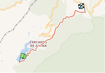
8 km | 10.6 km-effort
2h 53min
Yes
Trail Walking San Bartolomé de Tirajana - Canaries 2 - Photo
Walking
Jaceu

Walking

Very easy
San Bartolomé de Tirajana, Canary Islands, Las Palmas, Spain
17.2 km | 25 km-effort
6h 24min
No


Close
My subscriptions