Trail On foot Molina de Segura - PR-MU 73 Sierra del Águila - Photo

Tous les sentiers balisés d’Europe GUIDE+

© OpenStreetMap contributors
Length
Length
14.4 km
Max alt
Max alt
572 m
Uphill gradient
Uphill gradient
348 m
Km-Effort
Km-Effort  
19 km
Min alt
Min alt
345 m
Downhill gradient
Downhill gradient
328 m
Boucle
Boucle
No
Signpost
Signpost
Creation date :
2022-02-14 14:48:12.246
Updated on :
2022-02-14 14:48:12.246

(0 Reviews)

On foot
On foot
4h19
Difficulty : Easy

Scan this QR Code to open this trail in the SityTrail application

FREE GPS app for hiking

Logo SityTrail SityTrail

IGN / Geographical institutes

Download SityTrail from the App Store Download SityTrail from Google Play

Logo SityTrail SityTrail World

The world is yours!

Download SityTrail from the App Store Download SityTrail from Google Play Download SityTrail on Huawei AppGallery

About

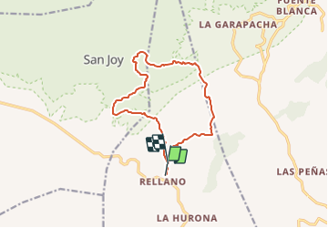
Trail On foot of 14.4 km to be discovered at Region of Murcia, Region of Murcia, Molina de Segura. This trail is proposed by SityTrail - itinéraires balisés pédestres.

Description

Symbol: white strip on top of yellow strip

Elevation profile

Positioning

Country:
Spain
Region :
Region of Murcia
Department/Province :
Region of Murcia
Municipality :
Molina de Segura
Location:
Unknown
Start:(UTM)
656456 ; 4229978 (30S) N.

Trails nearby

Trail Mountain bike Molina de Segura - Trasvase - Photo
Mountain bike
reyes

Mountain bike

Very easy
Molina de Segura, Region of Murcia, Region of Murcia, Spain
29 km | 35 km-effort
Unknown
No


Close
My subscriptions