![](/images/other/stat-length.png)
![Trail On foot Gave - Trilho da Aveleira - Photo](https://media.geolcdn.com/t/1900/400/6018125e-64be-41e9-abde-66c25136e8e7.jpeg&format=pjpeg&maxdim=2)
Trilho da Aveleira
SityTrail - itinéraires balisés pédestres
Tous les sentiers balisés d’Europe GUIDE+
![Length](/images/other/stat-length.png)
Length
6.8 km
![Max alt](https://static1.geolcdn.com/siteimages/upload/files/1508320355ic_sort_altitude_max_24dp.png)
Max alt
1169 m
![Uphill gradient](https://static1.geolcdn.com/siteimages/upload/files/1508320355ic_sort_den_pos_24dp.png)
Uphill gradient
187 m
![Km-Effort](/images/other/stat-length.png)
Km-Effort
9.3 km
![Min alt](https://static1.geolcdn.com/siteimages/upload/files/1508320355ic_sort_altitude_min_24dp.png)
Min alt
980 m
![Downhill gradient](https://static1.geolcdn.com/siteimages/upload/files/1508320355ic_sort_den_neg_24dp.png)
Downhill gradient
213 m
![Boucle](https://static1.geolcdn.com/siteimages/upload/files/16400158638029165_repeat_loop_refresh_sync_direction_icon.png)
Boucle
No
Signpost
Creation date :
2022-02-14 14:35:44.222
Updated on :
2022-02-14 14:35:44.222
![On foot](https://static1.geolcdn.com/sitytour/trail-icons/100.png)
2h07
Difficulty : Easy
![Scan this QR Code to open this trail in the SityTrail application](https://capi.geolives.com/qq0zvz2zws4bq2lad0pu/sitytour/trails/3108878/qr.png?size=200)
FREE GPS app for hiking
About
Trail On foot of 6.8 km to be discovered at North, Viana do Castelo, Gave. This trail is proposed by SityTrail - itinéraires balisés pédestres.
Description
Trail created by Junta de Freguesia de Gave, Concelho de Melgaço.
Symbol: Yellow over Red
Website: http://www.brandadaaveleira.com/index.php?p=52
Positioning
Country:
Portugal
Region :
North
Department/Province :
Viana do Castelo
Municipality :
Gave
Location:
Unknown
Start:(Dec)
Start:(UTM)
559164 ; 4649691 (29T) N.
Comments
Trails nearby
![Trail On foot Gavieira - Trilho da Peneda - Photo](https://media.geolcdn.com/t/375/260/56c8fda7-f936-480e-888e-5091a1bbf7a4.jpeg&format=jpg&maxdim=2)
![On foot On foot](https://static1.geolcdn.com/sitytour/trail-icons/100.png)
Trilho da Peneda
On foot
Easy
Gavieira,
North,
Viana do Castelo,
Portugal
![](/images/other/stat-length.png)
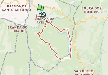
9.9 km | 17.1 km-effort
3h 53min
![](https://static1.geolcdn.com/siteimages/upload/files/16400158638029165_repeat_loop_refresh_sync_direction_icon.png)
Yes
![Trail On foot Sistelo - Trilho do Glaciar e do Alto Vez - Photo](https://media.geolcdn.com/t/375/260/bd21fd9d-3afa-47c4-a126-6b39aa6f99a8.jpeg&format=jpg&maxdim=2)
![On foot On foot](https://static1.geolcdn.com/sitytour/trail-icons/100.png)
Trilho do Glaciar e do Alto Vez
On foot
Easy
Sistelo,
North,
Viana do Castelo,
Portugal
![](/images/other/stat-length.png)
11 km | 17.9 km-effort
4h 3min
![](https://static1.geolcdn.com/siteimages/upload/files/16400158638029165_repeat_loop_refresh_sync_direction_icon.png)
No
![Trail On foot Gavieira - Trilho Pertinho do Céu - Photo](https://media.geolcdn.com/t/375/260/5879b54d-eccc-4fc8-be60-f37b12cf921b.jpeg&format=jpg&maxdim=2)
![On foot On foot](https://static1.geolcdn.com/sitytour/trail-icons/100.png)
Trilho Pertinho do Céu
On foot
Easy
Gavieira,
North,
Viana do Castelo,
Portugal
![](/images/other/stat-length.png)
8.1 km | 13.5 km-effort
3h 4min
![](https://static1.geolcdn.com/siteimages/upload/files/16400158638029165_repeat_loop_refresh_sync_direction_icon.png)
No