![](/images/other/stat-length.png)
![Trail On foot Rhenen - Grift en Graftenpad - Photo](https://media.geolcdn.com/t/1900/400/8ba69674-cdf9-4575-9a24-0b4bad74ecb7.jpeg&format=pjpeg&maxdim=2)
Grift en Graftenpad
SityTrail - itinéraires balisés pédestres
Tous les sentiers balisés d’Europe GUIDE+
![Length](/images/other/stat-length.png)
Length
11.7 km
![Max alt](https://static1.geolcdn.com/siteimages/upload/files/1508320355ic_sort_altitude_max_24dp.png)
Max alt
49 m
![Uphill gradient](https://static1.geolcdn.com/siteimages/upload/files/1508320355ic_sort_den_pos_24dp.png)
Uphill gradient
87 m
![Km-Effort](/images/other/stat-length.png)
Km-Effort
12.9 km
![Min alt](https://static1.geolcdn.com/siteimages/upload/files/1508320355ic_sort_altitude_min_24dp.png)
Min alt
3 m
![Downhill gradient](https://static1.geolcdn.com/siteimages/upload/files/1508320355ic_sort_den_neg_24dp.png)
Downhill gradient
87 m
![Boucle](https://static1.geolcdn.com/siteimages/upload/files/16400158638029165_repeat_loop_refresh_sync_direction_icon.png)
Boucle
Yes
Signpost
Creation date :
2022-02-14 14:35:33.634
Updated on :
2022-02-14 14:35:33.634
![On foot](https://static1.geolcdn.com/sitytour/trail-icons/100.png)
2h55
Difficulty : Easy
![Scan this QR Code to open this trail in the SityTrail application](https://capi.geolives.com/qq0zvz2zws4bq2lad0pu/sitytour/trails/3108870/qr.png?size=200)
FREE GPS app for hiking
About
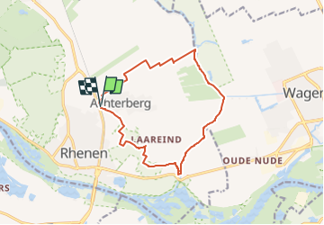
Trail On foot of 11.7 km to be discovered at Utrecht, Unknown, Rhenen. This trail is proposed by SityTrail - itinéraires balisés pédestres.
Description
Trail created by www.klompenpaden.nl.
Symbol: Wooden shoes / Klompjes
Positioning
Country:
Netherlands
Region :
Utrecht
Department/Province :
Unknown
Municipality :
Rhenen
Location:
Unknown
Start:(Dec)
Start:(UTM)
677127 ; 5761048 (31U) N.
Comments
Trails nearby
![Trail On foot Rhenen - NS-wandeling Blauwe Kamer - Photo](https://media.geolcdn.com/t/375/260/a8a6d689-8221-4caf-9a16-60dbeb60affd.jpeg&format=jpg&maxdim=2)
![On foot On foot](https://static1.geolcdn.com/sitytour/trail-icons/100.png)
NS-wandeling Blauwe Kamer
On foot
Easy
Rhenen,
Utrecht,
Unknown,
Netherlands
![](/images/other/stat-length.png)
14.6 km | 16.6 km-effort
3h 45min
![](https://static1.geolcdn.com/siteimages/upload/files/16400158638029165_repeat_loop_refresh_sync_direction_icon.png)
Yes
![Trail On foot Rhenen - NS-wandeltocht Elsterberg - Photo](https://media.geolcdn.com/t/375/260/defd0a88-0728-4c96-944f-28cc33973cdb.jpeg&format=jpg&maxdim=2)
![On foot On foot](https://static1.geolcdn.com/sitytour/trail-icons/100.png)
NS-wandeltocht Elsterberg
On foot
Medium
Rhenen,
Utrecht,
Unknown,
Netherlands
![](/images/other/stat-length.png)
17.7 km | 20 km-effort
4h 38min
![](https://static1.geolcdn.com/siteimages/upload/files/16400158638029165_repeat_loop_refresh_sync_direction_icon.png)
No
![Trail Walking Rhenen - w-gelderland-rhenen-opheusden - Photo](https://media.geolcdn.com/t/375/260/ext.jpg?maxdim=2&url=https%3A%2F%2Fstatic1.geolcdn.com%2Fsiteimages%2Fupload%2Ffiles%2F1553511878bg_sport_marche.png)
![Walking Walking](https://static1.geolcdn.com/sitytour/trail-icons/101.png)
w-gelderland-rhenen-opheusden
Walking
Very easy
(1)
Rhenen,
Utrecht,
Unknown,
Netherlands
![](/images/other/stat-length.png)
12 km | 13.2 km-effort
Unknown
![](https://static1.geolcdn.com/siteimages/upload/files/16400158638029165_repeat_loop_refresh_sync_direction_icon.png)
Yes
![Trail Walking Rhenen - Utrecht - wandeling Rondje Grebbeberg - Photo](https://media.geolcdn.com/t/375/260/ext.jpg?maxdim=2&url=https%3A%2F%2Fstatic1.geolcdn.com%2Fsiteimages%2Fupload%2Ffiles%2F1553511878bg_sport_marche.png)
![Walking Walking](https://static1.geolcdn.com/sitytour/trail-icons/101.png)
Utrecht - wandeling Rondje Grebbeberg
Walking
Very easy
(1)
Rhenen,
Utrecht,
Unknown,
Netherlands
![](/images/other/stat-length.png)
7.9 km | 9.1 km-effort
Unknown
![](https://static1.geolcdn.com/siteimages/upload/files/16400158638029165_repeat_loop_refresh_sync_direction_icon.png)
Yes
![Trail Walking Rhenen - Rondje Nederrijn - Photo](https://media.geolcdn.com/t/375/260/ext.jpg?maxdim=2&url=https%3A%2F%2Fstatic1.geolcdn.com%2Fsiteimages%2Fupload%2Ffiles%2F1553511878bg_sport_marche.png)
![Walking Walking](https://static1.geolcdn.com/sitytour/trail-icons/101.png)
Rondje Nederrijn
Walking
Easy
Rhenen,
Utrecht,
Unknown,
Netherlands
![](/images/other/stat-length.png)
10 km | 11.2 km-effort
Unknown
![](https://static1.geolcdn.com/siteimages/upload/files/16400158638029165_repeat_loop_refresh_sync_direction_icon.png)
Yes
![Trail Cycle Rhenen - Utrecht - Griftvalleiroute - Photo](https://media.geolcdn.com/t/375/260/ext.jpg?maxdim=2&url=https%3A%2F%2Fstatic1.geolcdn.com%2Fsiteimages%2Fupload%2Ffiles%2F1524743154velo.jpg)
![Cycle Cycle](https://static1.geolcdn.com/sitytour/trail-icons/200.png)
Utrecht - Griftvalleiroute
Cycle
Very easy
Rhenen,
Utrecht,
Unknown,
Netherlands
![](/images/other/stat-length.png)
23 km | 26 km-effort
Unknown
![](https://static1.geolcdn.com/siteimages/upload/files/16400158638029165_repeat_loop_refresh_sync_direction_icon.png)
Yes
![Trail Cycle Rhenen - Utrecht - betuwe heuvelrug route - Photo](https://media.geolcdn.com/t/375/260/ext.jpg?maxdim=2&url=https%3A%2F%2Fstatic1.geolcdn.com%2Fsiteimages%2Fupload%2Ffiles%2F1524743154velo.jpg)
![Cycle Cycle](https://static1.geolcdn.com/sitytour/trail-icons/200.png)
Utrecht - betuwe heuvelrug route
Cycle
Very easy
Rhenen,
Utrecht,
Unknown,
Netherlands
![](/images/other/stat-length.png)
65 km | 70 km-effort
Unknown
![](https://static1.geolcdn.com/siteimages/upload/files/16400158638029165_repeat_loop_refresh_sync_direction_icon.png)
Yes
![Trail Cycle Neder-Betuwe - Gelderland - Midden-Betuwe - Photo](https://media.geolcdn.com/t/375/260/ext.jpg?maxdim=2&url=https%3A%2F%2Fstatic1.geolcdn.com%2Fsiteimages%2Fupload%2Ffiles%2F1524743154velo.jpg)
![Cycle Cycle](https://static1.geolcdn.com/sitytour/trail-icons/200.png)
Gelderland - Midden-Betuwe
Cycle
Very easy
Neder-Betuwe,
Gelderland,
Unknown,
Netherlands
![](/images/other/stat-length.png)
47 km | 50 km-effort
Unknown
![](https://static1.geolcdn.com/siteimages/upload/files/16400158638029165_repeat_loop_refresh_sync_direction_icon.png)
Yes
![Trail Cycle Ede - Gelderland - Ede-Wageningen - Photo](https://media.geolcdn.com/t/375/260/ext.jpg?maxdim=2&url=https%3A%2F%2Fstatic1.geolcdn.com%2Fsiteimages%2Fupload%2Ffiles%2F1524743154velo.jpg)
![Cycle Cycle](https://static1.geolcdn.com/sitytour/trail-icons/200.png)
Gelderland - Ede-Wageningen
Cycle
Very easy
Ede,
Gelderland,
Unknown,
Netherlands
![](/images/other/stat-length.png)
44 km | 48 km-effort
Unknown
![](https://static1.geolcdn.com/siteimages/upload/files/16400158638029165_repeat_loop_refresh_sync_direction_icon.png)
Yes