![](/images/other/stat-length.png)
![Trail On foot Banyalbufar - Camí de sa Volta des General - Photo](https://media.geolcdn.com/t/1900/400/8b28ca13-a16d-4887-a8d7-ae1af2458aa6.jpeg&format=pjpeg&maxdim=2)
Camí de sa Volta des General
SityTrail - itinéraires balisés pédestres
Tous les sentiers balisés d’Europe GUIDE+
![Length](/images/other/stat-length.png)
Length
4.5 km
![Max alt](https://static1.geolcdn.com/siteimages/upload/files/1508320355ic_sort_altitude_max_24dp.png)
Max alt
190 m
![Uphill gradient](https://static1.geolcdn.com/siteimages/upload/files/1508320355ic_sort_den_pos_24dp.png)
Uphill gradient
91 m
![Km-Effort](/images/other/stat-length.png)
Km-Effort
6.2 km
![Min alt](https://static1.geolcdn.com/siteimages/upload/files/1508320355ic_sort_altitude_min_24dp.png)
Min alt
2 m
![Downhill gradient](https://static1.geolcdn.com/siteimages/upload/files/1508320355ic_sort_den_neg_24dp.png)
Downhill gradient
227 m
![Boucle](https://static1.geolcdn.com/siteimages/upload/files/16400158638029165_repeat_loop_refresh_sync_direction_icon.png)
Boucle
No
Signpost
Creation date :
2022-02-14 14:24:04.88
Updated on :
2022-02-14 14:24:04.88
![On foot](https://static1.geolcdn.com/sitytour/trail-icons/100.png)
1h24
Difficulty : Easy
![Scan this QR Code to open this trail in the SityTrail application](https://capi.geolives.com/qq0zvz2zws4bq2lad0pu/sitytour/trails/3108444/qr.png?size=200)
FREE GPS app for hiking
About
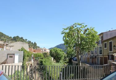
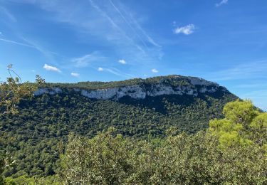
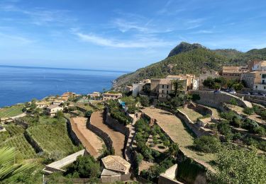
Trail On foot of 4.5 km to be discovered at Balearic Islands, Unknown, Banyalbufar. This trail is proposed by SityTrail - itinéraires balisés pédestres.
Description
I haven't seen a green circle with black 8 there...!?
Positioning
Country:
Spain
Region :
Balearic Islands
Department/Province :
Unknown
Municipality :
Banyalbufar
Location:
Unknown
Start:(Dec)
Start:(UTM)
459000 ; 4393463 (31S) N.
Comments
Trails nearby
![Trail On foot Banyalbufar - Camí des Pescadors - Photo](https://media.geolcdn.com/t/375/260/ede1eb3a-e761-43e6-b1d2-8ff02557f9d3.jpeg&format=jpg&maxdim=2)
![On foot On foot](https://static1.geolcdn.com/sitytour/trail-icons/100.png)
Camí des Pescadors
On foot
Easy
Banyalbufar,
Balearic Islands,
Unknown,
Spain
![](/images/other/stat-length.png)
5.3 km | 7.1 km-effort
1h 37min
![](https://static1.geolcdn.com/siteimages/upload/files/16400158638029165_repeat_loop_refresh_sync_direction_icon.png)
No
![Trail Walking Esporles - GR221 # Esporles - Valldemossa - Deià - Photo](https://media.geolcdn.com/t/375/260/603903a1-5ba6-4f6d-a37b-0ea644bbef6a.jpeg&format=jpg&maxdim=2)
![Walking Walking](https://static1.geolcdn.com/sitytour/trail-icons/101.png)
GR221 # Esporles - Valldemossa - Deià
Walking
Difficult
Esporles,
Balearic Islands,
Unknown,
Spain
![](/images/other/stat-length.png)
19.2 km | 35 km-effort
8h 52min
![](https://static1.geolcdn.com/siteimages/upload/files/16400158638029165_repeat_loop_refresh_sync_direction_icon.png)
No
![Trail Walking Estellencs - GR221 # Estellencs - Banyalbufar - Esporles - Photo](https://media.geolcdn.com/t/375/260/a5f3f2da-c0dd-4223-9da3-4cd5b790682e.jpg&format=jpg&maxdim=2)
![Walking Walking](https://static1.geolcdn.com/sitytour/trail-icons/101.png)
GR221 # Estellencs - Banyalbufar - Esporles
Walking
Medium
(2)
Estellencs,
Balearic Islands,
Unknown,
Spain
![](/images/other/stat-length.png)
16.1 km | 25 km-effort
4h 38min
![](https://static1.geolcdn.com/siteimages/upload/files/16400158638029165_repeat_loop_refresh_sync_direction_icon.png)
No
![Trail Walking Banyalbufar - ggggggt. - Photo](https://media.geolcdn.com/t/375/260/ext.jpg?maxdim=2&url=https%3A%2F%2Fstatic1.geolcdn.com%2Fsiteimages%2Fupload%2Ffiles%2F1553511878bg_sport_marche.png)
![Walking Walking](https://static1.geolcdn.com/sitytour/trail-icons/101.png)
ggggggt.
Walking
Medium
Banyalbufar,
Balearic Islands,
Unknown,
Spain
![](/images/other/stat-length.png)
16 km | 42 km-effort
2h 6min
![](https://static1.geolcdn.com/siteimages/upload/files/16400158638029165_repeat_loop_refresh_sync_direction_icon.png)
No
![Trail Walking Banyalbufar - Mallorca- Port d'es Canonge 13-10-2017 - Photo](https://media.geolcdn.com/t/375/260/ext.jpg?maxdim=2&url=https%3A%2F%2Fstatic1.geolcdn.com%2Fsiteimages%2Fupload%2Ffiles%2F1553511878bg_sport_marche.png)
![Walking Walking](https://static1.geolcdn.com/sitytour/trail-icons/101.png)
Mallorca- Port d'es Canonge 13-10-2017
Walking
Easy
Banyalbufar,
Balearic Islands,
Unknown,
Spain
![](/images/other/stat-length.png)
8.7 km | 13.4 km-effort
2h 9min
![](https://static1.geolcdn.com/siteimages/upload/files/16400158638029165_repeat_loop_refresh_sync_direction_icon.png)
Yes
![Trail Walking Esporles - Mallorca-Serra de Ram 10-10-2017 - Photo](https://media.geolcdn.com/t/375/260/ext.jpg?maxdim=2&url=https%3A%2F%2Fstatic1.geolcdn.com%2Fsiteimages%2Fupload%2Ffiles%2F1553511878bg_sport_marche.png)
![Walking Walking](https://static1.geolcdn.com/sitytour/trail-icons/101.png)
Mallorca-Serra de Ram 10-10-2017
Walking
Medium
Esporles,
Balearic Islands,
Unknown,
Spain
![](/images/other/stat-length.png)
10.1 km | 17.4 km-effort
3h 46min
![](https://static1.geolcdn.com/siteimages/upload/files/16400158638029165_repeat_loop_refresh_sync_direction_icon.png)
Yes
![Trail Walking Banyalbufar - RM-Banyalbufar-Port des Canonge - Photo](https://media.geolcdn.com/t/375/260/ext.jpg?maxdim=2&url=https%3A%2F%2Fstatic1.geolcdn.com%2Fsiteimages%2Fupload%2Ffiles%2F1553511878bg_sport_marche.png)
![Walking Walking](https://static1.geolcdn.com/sitytour/trail-icons/101.png)
RM-Banyalbufar-Port des Canonge
Walking
Easy
Banyalbufar,
Balearic Islands,
Unknown,
Spain
![](/images/other/stat-length.png)
5.3 km | 8.3 km-effort
1h 49min
![](https://static1.geolcdn.com/siteimages/upload/files/16400158638029165_repeat_loop_refresh_sync_direction_icon.png)
No
![Trail Walking Esporles - De Banyalbufar à Esporlès - Photo](https://media.geolcdn.com/t/375/260/ext.jpg?maxdim=2&url=https%3A%2F%2Fstatic1.geolcdn.com%2Fsiteimages%2Fupload%2Ffiles%2F1553511878bg_sport_marche.png)
![Walking Walking](https://static1.geolcdn.com/sitytour/trail-icons/101.png)
De Banyalbufar à Esporlès
Walking
Medium
Esporles,
Balearic Islands,
Unknown,
Spain
![](/images/other/stat-length.png)
8.4 km | 12.8 km-effort
2h 47min
![](https://static1.geolcdn.com/siteimages/upload/files/16400158638029165_repeat_loop_refresh_sync_direction_icon.png)
No
![Trail Walking Banyalbufar - 20221023majo - Photo](https://media.geolcdn.com/t/375/260/ext.jpg?maxdim=2&url=https%3A%2F%2Fstatic1.geolcdn.com%2Fsiteimages%2Fupload%2Ffiles%2F1553511878bg_sport_marche.png)
![Walking Walking](https://static1.geolcdn.com/sitytour/trail-icons/101.png)
20221023majo
Walking
Difficult
Banyalbufar,
Balearic Islands,
Unknown,
Spain
![](/images/other/stat-length.png)
9.3 km | 13.6 km-effort
4h 49min
![](https://static1.geolcdn.com/siteimages/upload/files/16400158638029165_repeat_loop_refresh_sync_direction_icon.png)
Yes