![](/images/other/stat-length.png)
![Trail On foot Stein am Rhein - Uferrundweg Stein am Rhein - Photo](https://media.geolcdn.com/t/1900/400/e513e5c3-8da9-4e7e-82ec-d18cb65fa8f7.jpeg&format=pjpeg&maxdim=2)
Uferrundweg Stein am Rhein
SityTrail - itinéraires balisés pédestres
Tous les sentiers balisés d’Europe GUIDE+
![Length](/images/other/stat-length.png)
Length
6.5 km
![Max alt](https://static1.geolcdn.com/siteimages/upload/files/1508320355ic_sort_altitude_max_24dp.png)
Max alt
419 m
![Uphill gradient](https://static1.geolcdn.com/siteimages/upload/files/1508320355ic_sort_den_pos_24dp.png)
Uphill gradient
82 m
![Km-Effort](/images/other/stat-length.png)
Km-Effort
7.6 km
![Min alt](https://static1.geolcdn.com/siteimages/upload/files/1508320355ic_sort_altitude_min_24dp.png)
Min alt
392 m
![Downhill gradient](https://static1.geolcdn.com/siteimages/upload/files/1508320355ic_sort_den_neg_24dp.png)
Downhill gradient
85 m
![Boucle](https://static1.geolcdn.com/siteimages/upload/files/16400158638029165_repeat_loop_refresh_sync_direction_icon.png)
Boucle
Yes
Signpost
Creation date :
2022-02-14 09:02:02.54
Updated on :
2022-02-14 09:02:02.54
![On foot](https://static1.geolcdn.com/sitytour/trail-icons/100.png)
1h44
Difficulty : Easy
![Scan this QR Code to open this trail in the SityTrail application](https://capi.geolives.com/qq0zvz2zws4bq2lad0pu/sitytour/trails/3107205/qr.png?size=200)
FREE GPS app for hiking
About
Trail On foot of 6.5 km to be discovered at Schaffhausen, Unknown, Stein am Rhein. This trail is proposed by SityTrail - itinéraires balisés pédestres.
Description
Trail created by Schaffhauser Wanderwege.
Symbol: gelbe Raute
Positioning
Country:
Switzerland
Region :
Schaffhausen
Department/Province :
Unknown
Municipality :
Stein am Rhein
Location:
Unknown
Start:(Dec)
Start:(UTM)
488749 ; 5278966 (32T) N.
Comments
Trails nearby
![Trail Cycle Stein am Rhein - bdr12_dRamsen - Photo](https://media.geolcdn.com/t/375/260/ext.jpg?maxdim=2&url=https%3A%2F%2Fstatic1.geolcdn.com%2Fsiteimages%2Fupload%2Ffiles%2F1524743154velo.jpg)
![Cycle Cycle](https://static1.geolcdn.com/sitytour/trail-icons/200.png)
bdr12_dRamsen
Cycle
Very easy
Stein am Rhein,
Schaffhausen,
Unknown,
Switzerland
![](/images/other/stat-length.png)
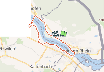
36 km | 48 km-effort
1h 52min
![](https://static1.geolcdn.com/siteimages/upload/files/16400158638029165_repeat_loop_refresh_sync_direction_icon.png)
No
![Trail Other activity Öhningen - bdr12_Stein_SH - Photo](https://media.geolcdn.com/t/375/260/ext.jpg?maxdim=2&url=https%3A%2F%2Fstatic1.geolcdn.com%2Fsiteimages%2Fupload%2Ffiles%2F1545311037marcheuse_200dpi.jpg)
![Other activity Other activity](https://static1.geolcdn.com/sitytour/trail-icons/900.png)
bdr12_Stein_SH
Other activity
Very easy
Öhningen,
Baden-Württemberg,
Landkreis Konstanz,
Germany
![](/images/other/stat-length.png)
141 km | 197 km-effort
43h 36min
![](https://static1.geolcdn.com/siteimages/upload/files/16400158638029165_repeat_loop_refresh_sync_direction_icon.png)
No
![Trail Other activity Eschenz - xxx11_Bodensee_Stein - Photo](https://media.geolcdn.com/t/375/260/ext.jpg?maxdim=2&url=https%3A%2F%2Fstatic1.geolcdn.com%2Fsiteimages%2Fupload%2Ffiles%2F1545311037marcheuse_200dpi.jpg)
![Other activity Other activity](https://static1.geolcdn.com/sitytour/trail-icons/900.png)
xxx11_Bodensee_Stein
Other activity
Very easy
Eschenz,
Thurgau,
Bezirk Frauenfeld,
Switzerland
![](/images/other/stat-length.png)
66 km | 67 km-effort
15h 6min
![](https://static1.geolcdn.com/siteimages/upload/files/16400158638029165_repeat_loop_refresh_sync_direction_icon.png)
No
![Trail Bicycle tourism Stein am Rhein - Stein Am Rhein - Singen (par les chuttes du Rhin) - Photo](https://media.geolcdn.com/t/375/260/ext.jpg?maxdim=2&url=https%3A%2F%2Fstatic1.geolcdn.com%2Fsiteimages%2Fupload%2Ffiles%2F1524743154velo.jpg)
![Bicycle tourism Bicycle tourism](https://static1.geolcdn.com/sitytour/trail-icons/204.png)
Stein Am Rhein - Singen (par les chuttes du Rhin)
Bicycle tourism
Very easy
Stein am Rhein,
Schaffhausen,
Unknown,
Switzerland
![](/images/other/stat-length.png)
79 km | 90 km-effort
Unknown
![](https://static1.geolcdn.com/siteimages/upload/files/16400158638029165_repeat_loop_refresh_sync_direction_icon.png)
No
![Trail Hybrid bike Stein am Rhein - Stein am Rhein – Dingelsdorf - Singen - Photo](https://media.geolcdn.com/t/375/260/ext.jpg?maxdim=2&url=https%3A%2F%2Fstatic1.geolcdn.com%2Fsiteimages%2Fupload%2Ffiles%2F1524743154velo.jpg)
![Hybrid bike Hybrid bike](https://static1.geolcdn.com/sitytour/trail-icons/203.png)
Stein am Rhein – Dingelsdorf - Singen
Hybrid bike
Very easy
Stein am Rhein,
Schaffhausen,
Unknown,
Switzerland
![](/images/other/stat-length.png)
86 km | 98 km-effort
Unknown
![](https://static1.geolcdn.com/siteimages/upload/files/16400158638029165_repeat_loop_refresh_sync_direction_icon.png)
No
![Trail Walking Stein am Rhein - YHH141 Stein am Rhein à Steckborn - Photo](https://media.geolcdn.com/t/375/260/ext.jpg?maxdim=2&url=https%3A%2F%2Fstatic1.geolcdn.com%2Fsiteimages%2Fupload%2Ffiles%2F1553511878bg_sport_marche.png)
![Walking Walking](https://static1.geolcdn.com/sitytour/trail-icons/101.png)
YHH141 Stein am Rhein à Steckborn
Walking
Medium
Stein am Rhein,
Schaffhausen,
Unknown,
Switzerland
![](/images/other/stat-length.png)
15.3 km | 21 km-effort
4h 15min
![](https://static1.geolcdn.com/siteimages/upload/files/16400158638029165_repeat_loop_refresh_sync_direction_icon.png)
No
![Trail Walking Stein am Rhein - Klingenzell TG - Sieben Schmerzen Mariä - Photo](https://media.geolcdn.com/t/375/260/ext.jpg?maxdim=2&url=https%3A%2F%2Fstatic1.geolcdn.com%2Fsiteimages%2Fupload%2Ffiles%2F1553511878bg_sport_marche.png)
![Walking Walking](https://static1.geolcdn.com/sitytour/trail-icons/101.png)
Klingenzell TG - Sieben Schmerzen Mariä
Walking
Very easy
Stein am Rhein,
Schaffhausen,
Unknown,
Switzerland
![](/images/other/stat-length.png)
11.7 km | 15.6 km-effort
3h 31min
![](https://static1.geolcdn.com/siteimages/upload/files/16400158638029165_repeat_loop_refresh_sync_direction_icon.png)
Yes
![Trail Walking Stammheim - Stammheim - Frauenfeld Klosterweg3 - Photo](https://media.geolcdn.com/t/375/260/ext.jpg?maxdim=2&url=https%3A%2F%2Fstatic1.geolcdn.com%2Fsiteimages%2Fupload%2Ffiles%2F1553511878bg_sport_marche.png)
![Walking Walking](https://static1.geolcdn.com/sitytour/trail-icons/101.png)
Stammheim - Frauenfeld Klosterweg3
Walking
Very easy
Stammheim,
Zurich,
Bezirk Andelfingen,
Switzerland
![](/images/other/stat-length.png)
15.8 km | 18.7 km-effort
4h 0min
![](https://static1.geolcdn.com/siteimages/upload/files/16400158638029165_repeat_loop_refresh_sync_direction_icon.png)
No
![Trail sport Eschenz - 3 - Photo](https://media.geolcdn.com/t/375/260/ext.jpg?maxdim=2&url=https%3A%2F%2Fsecurestorage.geolives.com%2Fsitytour%2Ftrail-bg%2Fdefault.jpg)
3
sport
Very easy
Eschenz,
Thurgau,
Bezirk Frauenfeld,
Switzerland
![](/images/other/stat-length.png)
4.2 km | 4.7 km-effort
Unknown
![](https://static1.geolcdn.com/siteimages/upload/files/16400158638029165_repeat_loop_refresh_sync_direction_icon.png)
No