![](/images/other/stat-length.png)
![Trail On foot Orsières - Sentier des Bergers - Photo](https://media.geolcdn.com/t/1900/400/a8cdee56-d9cf-46a0-9048-05577c82dfc2.jpeg&format=pjpeg&maxdim=2)
Sentier des Bergers
SityTrail - itinéraires balisés pédestres
Tous les sentiers balisés d’Europe GUIDE+
![Length](/images/other/stat-length.png)
Length
4.8 km
![Max alt](https://static1.geolcdn.com/siteimages/upload/files/1508320355ic_sort_altitude_max_24dp.png)
Max alt
2229 m
![Uphill gradient](https://static1.geolcdn.com/siteimages/upload/files/1508320355ic_sort_den_pos_24dp.png)
Uphill gradient
382 m
![Km-Effort](/images/other/stat-length.png)
Km-Effort
9.2 km
![Min alt](https://static1.geolcdn.com/siteimages/upload/files/1508320355ic_sort_altitude_min_24dp.png)
Min alt
1874 m
![Downhill gradient](https://static1.geolcdn.com/siteimages/upload/files/1508320355ic_sort_den_neg_24dp.png)
Downhill gradient
189 m
![Boucle](https://static1.geolcdn.com/siteimages/upload/files/16400158638029165_repeat_loop_refresh_sync_direction_icon.png)
Boucle
No
Signpost
Creation date :
2022-02-14 08:46:43.309
Updated on :
2022-02-14 08:46:43.309
![On foot](https://static1.geolcdn.com/sitytour/trail-icons/100.png)
2h05
Difficulty : Easy
![Scan this QR Code to open this trail in the SityTrail application](https://capi.geolives.com/qq0zvz2zws4bq2lad0pu/sitytour/trails/3106018/qr.png?size=200)
FREE GPS app for hiking
About
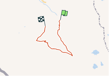
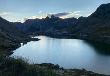
Trail On foot of 4.8 km to be discovered at Valais/Wallis, Entremont, Orsières. This trail is proposed by SityTrail - itinéraires balisés pédestres.
Description
Trail created by Office du Tourisme de La Fouly.
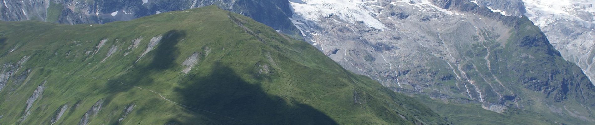
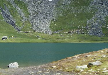
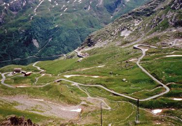
Hike from La Fouly to the medow of the Mont-Percé and back.
Positioning
Country:
Switzerland
Region :
Valais/Wallis
Department/Province :
Entremont
Municipality :
Orsières
Location:
Unknown
Start:(Dec)
Start:(UTM)
354253 ; 5084790 (32T) N.
Comments
Trails nearby
![Trail Walking Bourg-Saint-Pierre - st. Bernard - Photo](https://media.geolcdn.com/t/375/260/ext.jpg?maxdim=2&url=https%3A%2F%2Fservices.sitytrail.com%2FGeolivesWS%2FDownloadMedia.ashx%3FTrailID%3D210266%26Media%3Dfix__20130804173737.jpg)
![Walking Walking](https://static1.geolcdn.com/sitytour/trail-icons/101.png)
st. Bernard
Walking
Very easy
(2)
Bourg-Saint-Pierre,
Valais/Wallis,
Entremont,
Switzerland
![](/images/other/stat-length.png)
44 km | 116 km-effort
6h 17min
![](https://static1.geolcdn.com/siteimages/upload/files/16400158638029165_repeat_loop_refresh_sync_direction_icon.png)
No
![Trail On foot Bourg-Saint-Pierre - Chemins pédestres, région St-Bernard - Photo](https://media.geolcdn.com/t/375/260/3ecb502d-aa39-43c7-b4fa-d2f145975573.jpeg&format=jpg&maxdim=2)
![On foot On foot](https://static1.geolcdn.com/sitytour/trail-icons/100.png)
Chemins pédestres, région St-Bernard
On foot
Easy
Bourg-Saint-Pierre,
Valais/Wallis,
Entremont,
Switzerland
![](/images/other/stat-length.png)
8.6 km | 18.8 km-effort
4h 15min
![](https://static1.geolcdn.com/siteimages/upload/files/16400158638029165_repeat_loop_refresh_sync_direction_icon.png)
No
![Trail On foot Bourg-Saint-Pierre - Via Alpina Red R117 - Photo](https://media.geolcdn.com/t/375/260/13ce668d-e692-4cf0-91fa-ed93365ce626.jpeg&format=jpg&maxdim=2)
![On foot On foot](https://static1.geolcdn.com/sitytour/trail-icons/100.png)
Via Alpina Red R117
On foot
Very difficult
Bourg-Saint-Pierre,
Valais/Wallis,
Entremont,
Switzerland
![](/images/other/stat-length.png)
27 km | 46 km-effort
10h 25min
![](https://static1.geolcdn.com/siteimages/upload/files/16400158638029165_repeat_loop_refresh_sync_direction_icon.png)
No
![Trail On foot Orsières - Trail Verbier St-Bernard - Traversée - Photo](https://media.geolcdn.com/t/375/260/dafbc912-1c22-4e42-aaf9-5568981fc800.jpeg&format=jpg&maxdim=2)
![On foot On foot](https://static1.geolcdn.com/sitytour/trail-icons/100.png)
Trail Verbier St-Bernard - Traversée
On foot
Very difficult
Orsières,
Valais/Wallis,
Entremont,
Switzerland
![](/images/other/stat-length.png)
37 km | 70 km-effort
15h 47min
![](https://static1.geolcdn.com/siteimages/upload/files/16400158638029165_repeat_loop_refresh_sync_direction_icon.png)
No
![Trail Walking Orsières - La Fouly Ferret - Photo](https://media.geolcdn.com/t/375/260/9ccbcdc3-96f7-4967-963b-9422de80e17a.jpg&format=jpg&maxdim=2)
![Walking Walking](https://static1.geolcdn.com/sitytour/trail-icons/101.png)
La Fouly Ferret
Walking
Medium
Orsières,
Valais/Wallis,
Entremont,
Switzerland
![](/images/other/stat-length.png)
6.4 km | 9.7 km-effort
2h 58min
![](https://static1.geolcdn.com/siteimages/upload/files/16400158638029165_repeat_loop_refresh_sync_direction_icon.png)
Yes
![Trail Walking Bourg-Saint-Pierre - St Bernard - Photo](https://media.geolcdn.com/t/375/260/1947af24-c4d5-4de6-a636-7c1ee087fc5c.jpg&format=jpg&maxdim=2)
![Walking Walking](https://static1.geolcdn.com/sitytour/trail-icons/101.png)
St Bernard
Walking
Medium
Bourg-Saint-Pierre,
Valais/Wallis,
Entremont,
Switzerland
![](/images/other/stat-length.png)
4.7 km | 8.1 km-effort
2h 49min
![](https://static1.geolcdn.com/siteimages/upload/files/16400158638029165_repeat_loop_refresh_sync_direction_icon.png)
Yes
![Trail Walking Courmayeur - TMB J4 Ref.ELENA - COURMAYEUR - Photo](https://media.geolcdn.com/t/375/260/ext.jpg?maxdim=2&url=https%3A%2F%2Fservices.sitytrail.com%2FGeolivesWS%2FDownloadMedia.ashx%3FTrailID%3D594957%26Media%3Dfix__20160706110719.jpg)
![Walking Walking](https://static1.geolcdn.com/sitytour/trail-icons/101.png)
TMB J4 Ref.ELENA - COURMAYEUR
Walking
Medium
Courmayeur,
Aosta Valley,
Unknown,
Italy
![](/images/other/stat-length.png)
13.5 km | 22 km-effort
4h 18min
![](https://static1.geolcdn.com/siteimages/upload/files/16400158638029165_repeat_loop_refresh_sync_direction_icon.png)
No
![Trail Walking Orsières - La Fouly, Randonée hivernale, Sentier de l''Amône - Photo](https://media.geolcdn.com/t/375/260/ext.jpg?maxdim=2&url=https%3A%2F%2Fstatic1.geolcdn.com%2Fsiteimages%2Fupload%2Ffiles%2F1553511878bg_sport_marche.png)
![Walking Walking](https://static1.geolcdn.com/sitytour/trail-icons/101.png)
La Fouly, Randonée hivernale, Sentier de l''Amône
Walking
Very easy
(1)
Orsières,
Valais/Wallis,
Entremont,
Switzerland
![](/images/other/stat-length.png)
1.9 km | 2.7 km-effort
50min
![](https://static1.geolcdn.com/siteimages/upload/files/16400158638029165_repeat_loop_refresh_sync_direction_icon.png)
Yes
![Trail Walking Orsières - ferret La Foully - Photo](https://media.geolcdn.com/t/375/260/63d1d980-6a97-41e6-89ba-75cc5f32987c.jpg&format=jpg&maxdim=2)
![Walking Walking](https://static1.geolcdn.com/sitytour/trail-icons/101.png)
ferret La Foully
Walking
Medium
Orsières,
Valais/Wallis,
Entremont,
Switzerland
![](/images/other/stat-length.png)
4.6 km | 6.1 km-effort
2h 20min
![](https://static1.geolcdn.com/siteimages/upload/files/16400158638029165_repeat_loop_refresh_sync_direction_icon.png)
No