![](/images/other/stat-length.png)
![Trail On foot Juriens - TP Mollendruz - Romainmôtie - Photo](https://media.geolcdn.com/t/1900/400/ext.pjpeg?maxdim=2&url=https%3A%2F%2Fmedia.geolcdn.com%2Ff%2Fdev_7316eb13-f07d-4453-9d47-20985e85773c.jpeg)
TP Mollendruz - Romainmôtie
SityTrail - itinéraires balisés pédestres
Tous les sentiers balisés d’Europe PRO
![Length](/images/other/stat-length.png)
Length
7.8 km
![Max alt](https://static1.geolcdn.com/siteimages/upload/files/1508320355ic_sort_altitude_max_24dp.png)
Max alt
1275 m
![Uphill gradient](https://static1.geolcdn.com/siteimages/upload/files/1508320355ic_sort_den_pos_24dp.png)
Uphill gradient
352 m
![Km-Effort](/images/other/stat-length.png)
Km-Effort
11.6 km
![Min alt](https://static1.geolcdn.com/siteimages/upload/files/1508320355ic_sort_altitude_min_24dp.png)
Min alt
938 m
![Downhill gradient](https://static1.geolcdn.com/siteimages/upload/files/1508320355ic_sort_den_neg_24dp.png)
Downhill gradient
113 m
![Boucle](https://static1.geolcdn.com/siteimages/upload/files/16400158638029165_repeat_loop_refresh_sync_direction_icon.png)
Boucle
No
Signpost
Creation date :
2022-02-14 08:43:34.822
Updated on :
2022-02-14 08:43:34.822
![On foot](https://static1.geolcdn.com/sitytour/trail-icons/100.png)
2h38
Difficulty : Easy
![Scan this QR Code to open this trail in the SityTrail application](https://capi.geolives.com/qq0zvz2zws4bq2lad0pu/sitytour/trails/3105694/qr.png?size=200)
FREE GPS app for hiking
About
Trail On foot of 7.8 km to be discovered at Vaud, District du Jura-Nord vaudois, Juriens. This trail is proposed by SityTrail - itinéraires balisés pédestres.
Description
Trail created by Association Vaudoise de Tourisme Pédestre.
Positioning
Country:
Switzerland
Region :
Vaud
Department/Province :
District du Jura-Nord vaudois
Municipality :
Juriens
Location:
Unknown
Start:(Dec)
Start:(UTM)
304092 ; 5173703 (32T) N.
Comments
Trails nearby
![Trail Mountain bike Vallorbe - Le Suchet - Photo](https://media.geolcdn.com/t/375/260/ext.jpg?maxdim=2&url=https%3A%2F%2Fstatic1.geolcdn.com%2Fsiteimages%2Fupload%2Ffiles%2F1524743154velo.jpg)
![Mountain bike Mountain bike](https://static1.geolcdn.com/sitytour/trail-icons/202.png)
Le Suchet
Mountain bike
Very easy
(1)
Vallorbe,
Vaud,
District du Jura-Nord vaudois,
Switzerland
![](/images/other/stat-length.png)
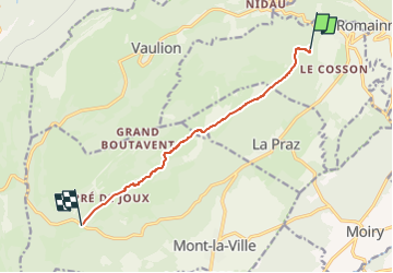
35 km | 53 km-effort
14h 41min
![](https://static1.geolcdn.com/siteimages/upload/files/16400158638029165_repeat_loop_refresh_sync_direction_icon.png)
Yes
![Trail On foot Les Clées - fixme - fixme - Photo](https://media.geolcdn.com/t/375/260/ext.jpg?maxdim=2&url=https%3A%2F%2Fmedia.geolcdn.com%2Ff%2F69516fc4-f099-4dd3-b5b2-2f14f3d78d3c.jpeg)
![On foot On foot](https://static1.geolcdn.com/sitytour/trail-icons/100.png)
fixme - fixme
On foot
Easy
Les Clées,
Vaud,
District du Jura-Nord vaudois,
Switzerland
![](/images/other/stat-length.png)
4.1 km | 5.9 km-effort
1h 20min
![](https://static1.geolcdn.com/siteimages/upload/files/16400158638029165_repeat_loop_refresh_sync_direction_icon.png)
No
![Trail On foot Les Clées - Tourisme pédestre - Photo](https://media.geolcdn.com/t/375/260/ext.jpg?maxdim=2&url=https%3A%2F%2Fmedia.geolcdn.com%2Ff%2F69516fc4-f099-4dd3-b5b2-2f14f3d78d3c.jpeg)
![On foot On foot](https://static1.geolcdn.com/sitytour/trail-icons/100.png)
Tourisme pédestre
On foot
Easy
Les Clées,
Vaud,
District du Jura-Nord vaudois,
Switzerland
![](/images/other/stat-length.png)
3.5 km | 4.5 km-effort
1h 0min
![](https://static1.geolcdn.com/siteimages/upload/files/16400158638029165_repeat_loop_refresh_sync_direction_icon.png)
No
![Trail On foot Ballaigues - Ballaigues-Vallorbe - Photo](https://media.geolcdn.com/t/375/260/ext.jpg?maxdim=2&url=https%3A%2F%2Fmedia.geolcdn.com%2Ff%2F94e39ae2-cd96-4289-ab6b-b58b7f70c35d.jpeg)
![On foot On foot](https://static1.geolcdn.com/sitytour/trail-icons/100.png)
Ballaigues-Vallorbe
On foot
Easy
Ballaigues,
Vaud,
District du Jura-Nord vaudois,
Switzerland
![](/images/other/stat-length.png)
5.1 km | 6.3 km-effort
1h 25min
![](https://static1.geolcdn.com/siteimages/upload/files/16400158638029165_repeat_loop_refresh_sync_direction_icon.png)
No
![Trail On foot Vaulion - Sur le Voué- - Photo](https://media.geolcdn.com/t/375/260/ext.jpg?maxdim=2&url=https%3A%2F%2Fstatic1.geolcdn.com%2Fsiteimages%2Fupload%2Ffiles%2F1545311037marcheuse_200dpi.jpg)
![On foot On foot](https://static1.geolcdn.com/sitytour/trail-icons/100.png)
Sur le Voué-
On foot
Easy
Vaulion,
Vaud,
District du Jura-Nord vaudois,
Switzerland
![](/images/other/stat-length.png)
3 km | 4.5 km-effort
1h 1min
![](https://static1.geolcdn.com/siteimages/upload/files/16400158638029165_repeat_loop_refresh_sync_direction_icon.png)
No
![Trail Walking Vallorbe - Vallorbe La Dent du Vaulion Fort du Pré Giroud 4 août 2020 CAF - Photo](https://media.geolcdn.com/t/375/260/ext.jpg?maxdim=2&url=https%3A%2F%2Fmedia.geolcdn.com%2Ff%2F51f06875-567a-49a6-9929-f56fedfeebf9.jpg)
![Walking Walking](https://static1.geolcdn.com/sitytour/trail-icons/101.png)
Vallorbe La Dent du Vaulion Fort du Pré Giroud 4 août 2020 CAF
Walking
Difficult
Vallorbe,
Vaud,
District du Jura-Nord vaudois,
Switzerland
![](/images/other/stat-length.png)
19.7 km | 32 km-effort
7h 1min
![](https://static1.geolcdn.com/siteimages/upload/files/16400158638029165_repeat_loop_refresh_sync_direction_icon.png)
Yes
![Trail Other activity Vallorbe - bdr18_dVallorbeGVA - Photo](https://media.geolcdn.com/t/375/260/ext.jpg?maxdim=2&url=https%3A%2F%2Fstatic1.geolcdn.com%2Fsiteimages%2Fupload%2Ffiles%2F1545311037marcheuse_200dpi.jpg)
![Other activity Other activity](https://static1.geolcdn.com/sitytour/trail-icons/900.png)
bdr18_dVallorbeGVA
Other activity
Very easy
Vallorbe,
Vaud,
District du Jura-Nord vaudois,
Switzerland
![](/images/other/stat-length.png)
95 km | 123 km-effort
27h 48min
![](https://static1.geolcdn.com/siteimages/upload/files/16400158638029165_repeat_loop_refresh_sync_direction_icon.png)
No
![Trail Other activity Romainmôtier-Envy - y10_Cascade du Dard - Photo](https://media.geolcdn.com/t/375/260/ext.jpg?maxdim=2&url=https%3A%2F%2Fstatic1.geolcdn.com%2Fsiteimages%2Fupload%2Ffiles%2F1545311037marcheuse_200dpi.jpg)
![Other activity Other activity](https://static1.geolcdn.com/sitytour/trail-icons/900.png)
y10_Cascade du Dard
Other activity
Very easy
Romainmôtier-Envy,
Vaud,
District du Jura-Nord vaudois,
Switzerland
![](/images/other/stat-length.png)
7.4 km | 8.7 km-effort
2h 7min
![](https://static1.geolcdn.com/siteimages/upload/files/16400158638029165_repeat_loop_refresh_sync_direction_icon.png)
No
![Trail Other activity Jougne - bdr18_Vallorbe_GVA - Photo](https://media.geolcdn.com/t/375/260/ext.jpg?maxdim=2&url=https%3A%2F%2Fstatic1.geolcdn.com%2Fsiteimages%2Fupload%2Ffiles%2F1545311037marcheuse_200dpi.jpg)
![Other activity Other activity](https://static1.geolcdn.com/sitytour/trail-icons/900.png)
bdr18_Vallorbe_GVA
Other activity
Very easy
Jougne,
Bourgogne-Franche-Comté,
Doubs,
France
![](/images/other/stat-length.png)
86 km | 119 km-effort
26h 21min
![](https://static1.geolcdn.com/siteimages/upload/files/16400158638029165_repeat_loop_refresh_sync_direction_icon.png)
No