![](/images/other/stat-length.png)
![Trail On foot Bad Salzdetfurth - Sölter-Weg - Photo](https://media.geolcdn.com/t/1900/400/578f3805-2242-484c-a9e4-a5ea73bea3fd.jpeg&format=pjpeg&maxdim=2)
Sölter-Weg
SityTrail - itinéraires balisés pédestres
Tous les sentiers balisés d’Europe GUIDE+
![Length](/images/other/stat-length.png)
Length
27 km
![Max alt](https://static1.geolcdn.com/siteimages/upload/files/1508320355ic_sort_altitude_max_24dp.png)
Max alt
327 m
![Uphill gradient](https://static1.geolcdn.com/siteimages/upload/files/1508320355ic_sort_den_pos_24dp.png)
Uphill gradient
765 m
![Km-Effort](/images/other/stat-length.png)
Km-Effort
37 km
![Min alt](https://static1.geolcdn.com/siteimages/upload/files/1508320355ic_sort_altitude_min_24dp.png)
Min alt
91 m
![Downhill gradient](https://static1.geolcdn.com/siteimages/upload/files/1508320355ic_sort_den_neg_24dp.png)
Downhill gradient
746 m
![Boucle](https://static1.geolcdn.com/siteimages/upload/files/16400158638029165_repeat_loop_refresh_sync_direction_icon.png)
Boucle
No
Signpost
Creation date :
2022-02-11 20:56:25.618
Updated on :
2022-02-11 20:56:25.618
![On foot](https://static1.geolcdn.com/sitytour/trail-icons/100.png)
8h20
Difficulty : Difficult
![Scan this QR Code to open this trail in the SityTrail application](https://capi.geolives.com/qq0zvz2zws4bq2lad0pu/sitytour/trails/3102353/qr.png?size=200)
FREE GPS app for hiking
About
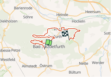
Trail On foot of 27 km to be discovered at Lower Saxony, Landkreis Hildesheim, Bad Salzdetfurth. This trail is proposed by SityTrail - itinéraires balisés pédestres.
Description
not yet published, signs are mounted, mapping is work-in-progress
Symbol: Wappenschild mit drei Salzhaken auf rotem Grund
Positioning
Country:
Germany
Region :
Lower Saxony
Department/Province :
Landkreis Hildesheim
Municipality :
Bad Salzdetfurth
Location:
Unknown
Start:(Dec)
Start:(UTM)
568329 ; 5767662 (32U) N.
Comments
Trails nearby
![Trail On foot Bad Salzdetfurth - R2 Rundwanderweg Ziegenberg - Photo](https://media.geolcdn.com/t/375/260/05f0189d-c0b9-4fc4-ad87-c395a8c87244.jpeg&format=jpg&maxdim=2)
![On foot On foot](https://static1.geolcdn.com/sitytour/trail-icons/100.png)
R2 Rundwanderweg Ziegenberg
On foot
Easy
Bad Salzdetfurth,
Lower Saxony,
Landkreis Hildesheim,
Germany
![](/images/other/stat-length.png)
8.8 km | 12.2 km-effort
2h 46min
![](https://static1.geolcdn.com/siteimages/upload/files/16400158638029165_repeat_loop_refresh_sync_direction_icon.png)
Yes
![Trail On foot Bad Salzdetfurth - R1 Rundwanderweg um den Sothenberg - Photo](https://media.geolcdn.com/t/375/260/05f0189d-c0b9-4fc4-ad87-c395a8c87244.jpeg&format=jpg&maxdim=2)
![On foot On foot](https://static1.geolcdn.com/sitytour/trail-icons/100.png)
R1 Rundwanderweg um den Sothenberg
On foot
Easy
Bad Salzdetfurth,
Lower Saxony,
Landkreis Hildesheim,
Germany
![](/images/other/stat-length.png)
4.2 km | 6.1 km-effort
1h 22min
![](https://static1.geolcdn.com/siteimages/upload/files/16400158638029165_repeat_loop_refresh_sync_direction_icon.png)
Yes
![Trail On foot Bad Salzdetfurth - Die Planetenstraße Bad Salzdetfurth - Photo](https://media.geolcdn.com/t/375/260/f23f4797-32a7-4541-8a56-bae75521ea06.jpeg&format=jpg&maxdim=2)
![On foot On foot](https://static1.geolcdn.com/sitytour/trail-icons/100.png)
Die Planetenstraße Bad Salzdetfurth
On foot
Easy
Bad Salzdetfurth,
Lower Saxony,
Landkreis Hildesheim,
Germany
![](/images/other/stat-length.png)
4.1 km | 4.5 km-effort
1h 1min
![](https://static1.geolcdn.com/siteimages/upload/files/16400158638029165_repeat_loop_refresh_sync_direction_icon.png)
No