![](/images/other/stat-length.png)
![Trail On foot Rottendorf - Würzburgs Stadtgrenze in 7 Teilen - Photo](https://media.geolcdn.com/t/1900/400/408aaa79-6d82-4e63-80eb-47913b213ef1.jpeg&format=pjpeg&maxdim=2)
Würzburgs Stadtgrenze in 7 Teilen
SityTrail - itinéraires balisés pédestres
Tous les sentiers balisés d’Europe GUIDE+
![Length](/images/other/stat-length.png)
Length
20 km
![Max alt](https://static1.geolcdn.com/siteimages/upload/files/1508320355ic_sort_altitude_max_24dp.png)
Max alt
319 m
![Uphill gradient](https://static1.geolcdn.com/siteimages/upload/files/1508320355ic_sort_den_pos_24dp.png)
Uphill gradient
432 m
![Km-Effort](/images/other/stat-length.png)
Km-Effort
26 km
![Min alt](https://static1.geolcdn.com/siteimages/upload/files/1508320355ic_sort_altitude_min_24dp.png)
Min alt
213 m
![Downhill gradient](https://static1.geolcdn.com/siteimages/upload/files/1508320355ic_sort_den_neg_24dp.png)
Downhill gradient
403 m
![Boucle](https://static1.geolcdn.com/siteimages/upload/files/16400158638029165_repeat_loop_refresh_sync_direction_icon.png)
Boucle
No
Signpost
Creation date :
2022-02-11 20:55:19.136
Updated on :
2022-02-11 20:55:19.136
![On foot](https://static1.geolcdn.com/sitytour/trail-icons/100.png)
5h51
Difficulty : Medium
![Scan this QR Code to open this trail in the SityTrail application](https://capi.geolives.com/qq0zvz2zws4bq2lad0pu/sitytour/trails/3102339/qr.png?size=200)
FREE GPS app for hiking
About
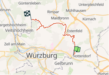
Trail On foot of 20 km to be discovered at Bavaria, Landkreis Würzburg, Rottendorf. This trail is proposed by SityTrail - itinéraires balisés pédestres.
Description
Trail created by Stadt Würzburg, Baureferat, Fachbereich Tiefbau und Verkehrswesen.
Positioning
Country:
Germany
Region :
Bavaria
Department/Province :
Landkreis Würzburg
Municipality :
Rottendorf
Location:
Unknown
Start:(Dec)
Start:(UTM)
572282 ; 5515938 (32U) N.
Comments
Trails nearby
![Trail On foot Rottendorf - Würzburgs Stadtgrenze, 1. Teil - Photo](https://media.geolcdn.com/t/375/260/ca2faa3f-2d45-4dec-8084-83501c9c33fb.jpeg&format=jpg&maxdim=2)
![On foot On foot](https://static1.geolcdn.com/sitytour/trail-icons/100.png)
Würzburgs Stadtgrenze, 1. Teil
On foot
Easy
Rottendorf,
Bavaria,
Landkreis Würzburg,
Germany
![](/images/other/stat-length.png)
7.8 km | 9.4 km-effort
2h 7min
![](https://static1.geolcdn.com/siteimages/upload/files/16400158638029165_repeat_loop_refresh_sync_direction_icon.png)
No
![Trail On foot - Würzburgs Stadtgrenze, 2. Teil - Photo](https://media.geolcdn.com/t/375/260/408aaa79-6d82-4e63-80eb-47913b213ef1.jpeg&format=jpg&maxdim=2)
![On foot On foot](https://static1.geolcdn.com/sitytour/trail-icons/100.png)
Würzburgs Stadtgrenze, 2. Teil
On foot
Easy
,
Bavaria,
Würzburg,
Germany
![](/images/other/stat-length.png)
8.5 km | 10.9 km-effort
2h 28min
![](https://static1.geolcdn.com/siteimages/upload/files/16400158638029165_repeat_loop_refresh_sync_direction_icon.png)
No
![Trail On foot - Würzburgs Stadtgrenze, 7. Teil - Photo](https://media.geolcdn.com/t/375/260/ca2faa3f-2d45-4dec-8084-83501c9c33fb.jpeg&format=jpg&maxdim=2)
![On foot On foot](https://static1.geolcdn.com/sitytour/trail-icons/100.png)
Würzburgs Stadtgrenze, 7. Teil
On foot
Easy
,
Bavaria,
Würzburg,
Germany
![](/images/other/stat-length.png)
7.2 km | 9 km-effort
2h 2min
![](https://static1.geolcdn.com/siteimages/upload/files/16400158638029165_repeat_loop_refresh_sync_direction_icon.png)
No
![Trail On foot Randersacker - Weinwanderung 'Teufelskeller' - Photo](https://media.geolcdn.com/t/375/260/58d3a30f-26c2-467f-8560-fc384f8b94ec.jpeg&format=jpg&maxdim=2)
![On foot On foot](https://static1.geolcdn.com/sitytour/trail-icons/100.png)
Weinwanderung 'Teufelskeller'
On foot
Easy
Randersacker,
Bavaria,
Landkreis Würzburg,
Germany
![](/images/other/stat-length.png)
6.2 km | 8.3 km-effort
1h 53min
![](https://static1.geolcdn.com/siteimages/upload/files/16400158638029165_repeat_loop_refresh_sync_direction_icon.png)
Yes
![Trail On foot Randersacker - Weinwanderung 'Sonnenstuhl' - Photo](https://media.geolcdn.com/t/375/260/74646b68-9d66-4631-a3b7-d98532cee10b.jpeg&format=jpg&maxdim=2)
![On foot On foot](https://static1.geolcdn.com/sitytour/trail-icons/100.png)
Weinwanderung 'Sonnenstuhl'
On foot
Easy
Randersacker,
Bavaria,
Landkreis Würzburg,
Germany
![](/images/other/stat-length.png)
4.4 km | 5.9 km-effort
1h 20min
![](https://static1.geolcdn.com/siteimages/upload/files/16400158638029165_repeat_loop_refresh_sync_direction_icon.png)
No
![Trail On foot Randersacker - Weinwanderung 'Ewig Leben' - Photo](https://media.geolcdn.com/t/375/260/58d3a30f-26c2-467f-8560-fc384f8b94ec.jpeg&format=jpg&maxdim=2)
![On foot On foot](https://static1.geolcdn.com/sitytour/trail-icons/100.png)
Weinwanderung 'Ewig Leben'
On foot
Easy
Randersacker,
Bavaria,
Landkreis Würzburg,
Germany
![](/images/other/stat-length.png)
8.2 km | 10.6 km-effort
2h 24min
![](https://static1.geolcdn.com/siteimages/upload/files/16400158638029165_repeat_loop_refresh_sync_direction_icon.png)
Yes
![Trail On foot Randersacker - Weinwanderung 'Marsberg' - Photo](https://media.geolcdn.com/t/375/260/e5acda0c-e305-4f12-97a0-c42f680f37fd.jpeg&format=jpg&maxdim=2)
![On foot On foot](https://static1.geolcdn.com/sitytour/trail-icons/100.png)
Weinwanderung 'Marsberg'
On foot
Easy
Randersacker,
Bavaria,
Landkreis Würzburg,
Germany
![](/images/other/stat-length.png)
6.7 km | 8.4 km-effort
1h 55min
![](https://static1.geolcdn.com/siteimages/upload/files/16400158638029165_repeat_loop_refresh_sync_direction_icon.png)
Yes
![Trail On foot Randersacker - Weinwanderung 'Lämmerberg' - Photo](https://media.geolcdn.com/t/375/260/58d3a30f-26c2-467f-8560-fc384f8b94ec.jpeg&format=jpg&maxdim=2)
![On foot On foot](https://static1.geolcdn.com/sitytour/trail-icons/100.png)
Weinwanderung 'Lämmerberg'
On foot
Easy
Randersacker,
Bavaria,
Landkreis Würzburg,
Germany
![](/images/other/stat-length.png)
3.4 km | 4.7 km-effort
1h 4min
![](https://static1.geolcdn.com/siteimages/upload/files/16400158638029165_repeat_loop_refresh_sync_direction_icon.png)
Yes
![Trail On foot Randersacker - Weinwanderung 'Pfülben' - Photo](https://media.geolcdn.com/t/375/260/5dbf0ce4-574a-4577-983c-4caf9e615fd6.jpeg&format=jpg&maxdim=2)
![On foot On foot](https://static1.geolcdn.com/sitytour/trail-icons/100.png)
Weinwanderung 'Pfülben'
On foot
Easy
Randersacker,
Bavaria,
Landkreis Würzburg,
Germany
![](/images/other/stat-length.png)
3.7 km | 5.1 km-effort
1h 10min
![](https://static1.geolcdn.com/siteimages/upload/files/16400158638029165_repeat_loop_refresh_sync_direction_icon.png)
Yes