![](/images/other/stat-length.png)
![Trail On foot Steffeln - Georundweg Steffeln - Photo](https://media.geolcdn.com/t/1900/400/2dd48710-1fdf-44c6-86c1-df2458f9f525.jpeg&format=pjpeg&maxdim=2)
Georundweg Steffeln
SityTrail - itinéraires balisés pédestres
Tous les sentiers balisés d’Europe GUIDE+
![Length](/images/other/stat-length.png)
Length
10.7 km
![Max alt](https://static1.geolcdn.com/siteimages/upload/files/1508320355ic_sort_altitude_max_24dp.png)
Max alt
552 m
![Uphill gradient](https://static1.geolcdn.com/siteimages/upload/files/1508320355ic_sort_den_pos_24dp.png)
Uphill gradient
199 m
![Km-Effort](/images/other/stat-length.png)
Km-Effort
13.3 km
![Min alt](https://static1.geolcdn.com/siteimages/upload/files/1508320355ic_sort_altitude_min_24dp.png)
Min alt
448 m
![Downhill gradient](https://static1.geolcdn.com/siteimages/upload/files/1508320355ic_sort_den_neg_24dp.png)
Downhill gradient
198 m
![Boucle](https://static1.geolcdn.com/siteimages/upload/files/16400158638029165_repeat_loop_refresh_sync_direction_icon.png)
Boucle
Yes
Signpost
Creation date :
2022-02-11 20:51:52.475
Updated on :
2022-02-11 20:51:52.475
![On foot](https://static1.geolcdn.com/sitytour/trail-icons/100.png)
3h01
Difficulty : Easy
![Scan this QR Code to open this trail in the SityTrail application](https://capi.geolives.com/qq0zvz2zws4bq2lad0pu/sitytour/trails/3102280/qr.png?size=200)
FREE GPS app for hiking
About
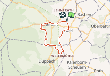
Trail On foot of 10.7 km to be discovered at Rhineland-Palatinate, Landkreis Vulkaneifel, Steffeln. This trail is proposed by SityTrail - itinéraires balisés pédestres.
Description
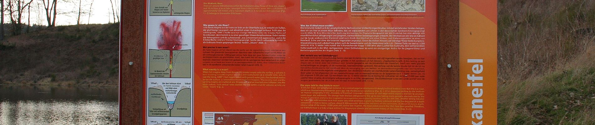
eichholzmaar, steffeln, duppach, vulkangarten, geo, rundweg, wandern, vulakneifel, natur, geologie, maare, dreese, vulkane
Website: http://eifelsteig-partnerwege.de/GEORUNDWEG_STEFFELN.html
Positioning
Country:
Germany
Region :
Rhineland-Palatinate
Department/Province :
Landkreis Vulkaneifel
Municipality :
Steffeln
Location:
Unknown
Start:(Dec)
Start:(UTM)
328044 ; 5573555 (32U) N.
Comments
Trails nearby
![Trail On foot Steffeln - Stelleln Nr. 2 - Photo](https://media.geolcdn.com/t/375/260/c867d715-8cfa-4a67-8020-75344c75248b.jpeg&format=jpg&maxdim=2)
![On foot On foot](https://static1.geolcdn.com/sitytour/trail-icons/100.png)
Stelleln Nr. 2
On foot
Easy
Steffeln,
Rhineland-Palatinate,
Landkreis Vulkaneifel,
Germany
![](/images/other/stat-length.png)
6.6 km | 7.8 km-effort
1h 46min
![](https://static1.geolcdn.com/siteimages/upload/files/16400158638029165_repeat_loop_refresh_sync_direction_icon.png)
No
![Trail On foot Steffeln - Stelleln 1 - Photo](https://media.geolcdn.com/t/375/260/c867d715-8cfa-4a67-8020-75344c75248b.jpeg&format=jpg&maxdim=2)
![On foot On foot](https://static1.geolcdn.com/sitytour/trail-icons/100.png)
Stelleln 1
On foot
Easy
Steffeln,
Rhineland-Palatinate,
Landkreis Vulkaneifel,
Germany
![](/images/other/stat-length.png)
4.3 km | 5.7 km-effort
1h 18min
![](https://static1.geolcdn.com/siteimages/upload/files/16400158638029165_repeat_loop_refresh_sync_direction_icon.png)
No