![](/images/other/stat-length.png)
![Trail On foot Oberhof - Rundweg Oberhof - Photo](https://media.geolcdn.com/t/1900/400/0897e82c-e273-46ab-8b48-9a1ec9d46659.jpeg&format=pjpeg&maxdim=2)
Rundweg Oberhof
SityTrail - itinéraires balisés pédestres
Tous les sentiers balisés d’Europe GUIDE+
![Length](/images/other/stat-length.png)
Length
6 km
![Max alt](https://static1.geolcdn.com/siteimages/upload/files/1508320355ic_sort_altitude_max_24dp.png)
Max alt
866 m
![Uphill gradient](https://static1.geolcdn.com/siteimages/upload/files/1508320355ic_sort_den_pos_24dp.png)
Uphill gradient
173 m
![Km-Effort](/images/other/stat-length.png)
Km-Effort
8.1 km
![Min alt](https://static1.geolcdn.com/siteimages/upload/files/1508320355ic_sort_altitude_min_24dp.png)
Min alt
772 m
![Downhill gradient](https://static1.geolcdn.com/siteimages/upload/files/1508320355ic_sort_den_neg_24dp.png)
Downhill gradient
106 m
![Boucle](https://static1.geolcdn.com/siteimages/upload/files/16400158638029165_repeat_loop_refresh_sync_direction_icon.png)
Boucle
No
Signpost
Creation date :
2022-02-11 20:48:52.351
Updated on :
2022-02-11 20:48:52.351
![On foot](https://static1.geolcdn.com/sitytour/trail-icons/100.png)
1h49
Difficulty : Easy
![Scan this QR Code to open this trail in the SityTrail application](https://capi.geolives.com/qq0zvz2zws4bq2lad0pu/sitytour/trails/3102240/qr.png?size=200)
FREE GPS app for hiking
About
Trail On foot of 6 km to be discovered at Thuringia, Landkreis Schmalkalden-Meiningen, Oberhof. This trail is proposed by SityTrail - itinéraires balisés pédestres.
Description
Trail created by Oberhofer Freizeit und Tourismus GmbH.
Symbol: wandernder Schneemann - Schneemann "Flocke" mit Wanderstock
Positioning
Country:
Germany
Region :
Thuringia
Department/Province :
Landkreis Schmalkalden-Meiningen
Municipality :
Oberhof
Location:
Unknown
Start:(Dec)
Start:(UTM)
621605 ; 5618646 (32U) N.
Comments
Trails nearby
![Trail On foot Geratal - Rundwanderweg Lütsche-Flößgraben - Photo](https://media.geolcdn.com/t/375/260/8a9b2621-9b90-4120-a048-e59a838772b6.jpeg&format=jpg&maxdim=2)
![On foot On foot](https://static1.geolcdn.com/sitytour/trail-icons/100.png)
Rundwanderweg Lütsche-Flößgraben
On foot
Easy
Geratal,
Thuringia,
Ilm-Kreis,
Germany
![](/images/other/stat-length.png)
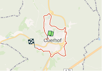
11.3 km | 14 km-effort
3h 10min
![](https://static1.geolcdn.com/siteimages/upload/files/16400158638029165_repeat_loop_refresh_sync_direction_icon.png)
No
![Trail On foot Oberhof - Rennsteig-Leiter Luisenthal - Photo](https://media.geolcdn.com/t/375/260/9acafe20-24a0-422d-8647-3deb8965a30b.jpeg&format=jpg&maxdim=2)
![On foot On foot](https://static1.geolcdn.com/sitytour/trail-icons/100.png)
Rennsteig-Leiter Luisenthal
On foot
Easy
Oberhof,
Thuringia,
Landkreis Schmalkalden-Meiningen,
Germany
![](/images/other/stat-length.png)
9.3 km | 11.2 km-effort
2h 33min
![](https://static1.geolcdn.com/siteimages/upload/files/16400158638029165_repeat_loop_refresh_sync_direction_icon.png)
No
![Trail On foot Oberhof - Rennsteig-Leiter Zella-Mehlis - Photo](https://media.geolcdn.com/t/375/260/00739d90-7ec6-484e-a1f2-dd6ddcae8ad1.jpeg&format=jpg&maxdim=2)
![On foot On foot](https://static1.geolcdn.com/sitytour/trail-icons/100.png)
Rennsteig-Leiter Zella-Mehlis
On foot
Easy
Oberhof,
Thuringia,
Landkreis Schmalkalden-Meiningen,
Germany
![](/images/other/stat-length.png)
3.6 km | 5.3 km-effort
1h 12min
![](https://static1.geolcdn.com/siteimages/upload/files/16400158638029165_repeat_loop_refresh_sync_direction_icon.png)
No
![Trail On foot Unknown - Gipfelwanderweg Suhl (Thüringer Wald) - Photo](https://media.geolcdn.com/t/375/260/6bb7536f-38cf-4075-ab68-998255e07ff8.jpeg&format=jpg&maxdim=2)
![On foot On foot](https://static1.geolcdn.com/sitytour/trail-icons/100.png)
Gipfelwanderweg Suhl (Thüringer Wald)
On foot
Medium
Unknown,
Thuringia,
Suhl,
Germany
![](/images/other/stat-length.png)
18 km | 24 km-effort
5h 31min
![](https://static1.geolcdn.com/siteimages/upload/files/16400158638029165_repeat_loop_refresh_sync_direction_icon.png)
No
![Trail On foot Geratal - Alter Flößgraben - Photo](https://media.geolcdn.com/t/375/260/ext.jpg?maxdim=2&url=https%3A%2F%2Fstatic1.geolcdn.com%2Fsiteimages%2Fupload%2Ffiles%2F1545311037marcheuse_200dpi.jpg)
![On foot On foot](https://static1.geolcdn.com/sitytour/trail-icons/100.png)
Alter Flößgraben
On foot
Easy
Geratal,
Thuringia,
Ilm-Kreis,
Germany
![](/images/other/stat-length.png)
12.2 km | 14.8 km-effort
3h 21min
![](https://static1.geolcdn.com/siteimages/upload/files/16400158638029165_repeat_loop_refresh_sync_direction_icon.png)
No
![Trail On foot Steinbach-Hallenberg - DE-Gelber Strich - Photo](https://media.geolcdn.com/t/375/260/ext.jpg?maxdim=2&url=https%3A%2F%2Fstatic1.geolcdn.com%2Fsiteimages%2Fupload%2Ffiles%2F1545311037marcheuse_200dpi.jpg)
![On foot On foot](https://static1.geolcdn.com/sitytour/trail-icons/100.png)
DE-Gelber Strich
On foot
Easy
Steinbach-Hallenberg,
Thuringia,
Landkreis Schmalkalden-Meiningen,
Germany
![](/images/other/stat-length.png)
3.7 km | 5.6 km-effort
1h 16min
![](https://static1.geolcdn.com/siteimages/upload/files/16400158638029165_repeat_loop_refresh_sync_direction_icon.png)
No
![Trail On foot Luisenthal - Herrenweg - Photo](https://media.geolcdn.com/t/375/260/ext.jpg?maxdim=2&url=https%3A%2F%2Fstatic1.geolcdn.com%2Fsiteimages%2Fupload%2Ffiles%2F1545311037marcheuse_200dpi.jpg)
![On foot On foot](https://static1.geolcdn.com/sitytour/trail-icons/100.png)
Herrenweg
On foot
Easy
Luisenthal,
Thuringia,
Landkreis Gotha,
Germany
![](/images/other/stat-length.png)
3.5 km | 4.4 km-effort
1h 0min
![](https://static1.geolcdn.com/siteimages/upload/files/16400158638029165_repeat_loop_refresh_sync_direction_icon.png)
No
![Trail On foot Unknown - Wilderer-Pfad - Photo](https://media.geolcdn.com/t/375/260/ext.jpg?maxdim=2&url=https%3A%2F%2Fstatic1.geolcdn.com%2Fsiteimages%2Fupload%2Ffiles%2F1545311037marcheuse_200dpi.jpg)
![On foot On foot](https://static1.geolcdn.com/sitytour/trail-icons/100.png)