![](/images/other/stat-length.png)
![Trail On foot Limburg a. d. Lahn - Südroute Limburg - Photo](https://media.geolcdn.com/t/1900/400/9b48fb64-2330-4cb9-82e9-adc99cc19a96.jpeg&format=pjpeg&maxdim=2)
Südroute Limburg
SityTrail - itinéraires balisés pédestres
Tous les sentiers balisés d’Europe GUIDE+
![Length](/images/other/stat-length.png)
Length
11.8 km
![Max alt](https://static1.geolcdn.com/siteimages/upload/files/1508320355ic_sort_altitude_max_24dp.png)
Max alt
299 m
![Uphill gradient](https://static1.geolcdn.com/siteimages/upload/files/1508320355ic_sort_den_pos_24dp.png)
Uphill gradient
170 m
![Km-Effort](/images/other/stat-length.png)
Km-Effort
14 km
![Min alt](https://static1.geolcdn.com/siteimages/upload/files/1508320355ic_sort_altitude_min_24dp.png)
Min alt
154 m
![Downhill gradient](https://static1.geolcdn.com/siteimages/upload/files/1508320355ic_sort_den_neg_24dp.png)
Downhill gradient
161 m
![Boucle](https://static1.geolcdn.com/siteimages/upload/files/16400158638029165_repeat_loop_refresh_sync_direction_icon.png)
Boucle
No
Signpost
Creation date :
2022-02-11 20:33:09.786
Updated on :
2022-02-11 20:33:09.786
![On foot](https://static1.geolcdn.com/sitytour/trail-icons/100.png)
3h10
Difficulty : Easy
![Scan this QR Code to open this trail in the SityTrail application](https://capi.geolives.com/qq0zvz2zws4bq2lad0pu/sitytour/trails/3101949/qr.png?size=200)
FREE GPS app for hiking
About
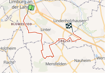
Trail On foot of 11.8 km to be discovered at Hesse, Landkreis Limburg-Weilburg, Limburg a. d. Lahn. This trail is proposed by SityTrail - itinéraires balisés pédestres.
Description
Trail created by Stadt Limburg a. d. Lahn.
Symbol: Rot auf weiß: LM\nS mit Rahmen, rechts unten Fußabdrücke
Positioning
Country:
Germany
Region :
Hesse
Department/Province :
Landkreis Limburg-Weilburg
Municipality :
Limburg a. d. Lahn
Location:
Unknown
Start:(Dec)
Start:(UTM)
433990 ; 5581293 (32U) N.
Comments
Trails nearby
![Trail On foot Diez - Halfterweg - Photo](https://media.geolcdn.com/t/375/260/6089030c-7b07-41da-a831-245903a717d7.jpeg&format=jpg&maxdim=2)
![On foot On foot](https://static1.geolcdn.com/sitytour/trail-icons/100.png)
Halfterweg
On foot
Medium
Diez,
Rhineland-Palatinate,
Rhein-Lahn-Kreis,
Germany
![](/images/other/stat-length.png)
18.5 km | 24 km-effort
5h 24min
![](https://static1.geolcdn.com/siteimages/upload/files/16400158638029165_repeat_loop_refresh_sync_direction_icon.png)
No