![](/images/other/stat-length.png)
![Trail On foot Hörstel - Teutoschleife Bevergerner Pättken - Photo](https://media.geolcdn.com/t/1900/400/48d19acf-e543-4175-922c-3714349c355f.jpeg&format=pjpeg&maxdim=2)
Teutoschleife Bevergerner Pättken
SityTrail - itinéraires balisés pédestres
Tous les sentiers balisés d’Europe GUIDE+
![Length](/images/other/stat-length.png)
Length
7 km
![Max alt](https://static1.geolcdn.com/siteimages/upload/files/1508320355ic_sort_altitude_max_24dp.png)
Max alt
97 m
![Uphill gradient](https://static1.geolcdn.com/siteimages/upload/files/1508320355ic_sort_den_pos_24dp.png)
Uphill gradient
73 m
![Km-Effort](/images/other/stat-length.png)
Km-Effort
8 km
![Min alt](https://static1.geolcdn.com/siteimages/upload/files/1508320355ic_sort_altitude_min_24dp.png)
Min alt
40 m
![Downhill gradient](https://static1.geolcdn.com/siteimages/upload/files/1508320355ic_sort_den_neg_24dp.png)
Downhill gradient
74 m
![Boucle](https://static1.geolcdn.com/siteimages/upload/files/16400158638029165_repeat_loop_refresh_sync_direction_icon.png)
Boucle
Yes
Signpost
Creation date :
2022-02-11 20:32:25.085
Updated on :
2022-02-11 20:32:25.085
![On foot](https://static1.geolcdn.com/sitytour/trail-icons/100.png)
1h48
Difficulty : Easy
![Scan this QR Code to open this trail in the SityTrail application](https://capi.geolives.com/qq0zvz2zws4bq2lad0pu/sitytour/trails/3101940/qr.png?size=200)
FREE GPS app for hiking
About
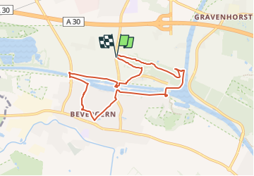
Trail On foot of 7 km to be discovered at North Rhine-Westphalia, Kreis Steinfurt, Hörstel. This trail is proposed by SityTrail - itinéraires balisés pédestres.
Description
Trail created by Tecklenburger Land-Tourismus.
Symbol: stilisiertes Schleifenmuster mit Schriftzug Teutoschleife und Zusatz Bevergerner Pättken
Positioning
Country:
Germany
Region :
North Rhine-Westphalia
Department/Province :
Kreis Steinfurt
Municipality :
Hörstel
Location:
Unknown
Start:(Dec)
Start:(UTM)
403684 ; 5793405 (32U) N.
Comments
Trails nearby
![Trail On foot Hörstel - Teutoschleife Waldauenweg - Photo](https://media.geolcdn.com/t/375/260/77658872-02f1-4e3e-8abb-7e68d9f80246.jpeg&format=jpg&maxdim=2)
![On foot On foot](https://static1.geolcdn.com/sitytour/trail-icons/100.png)
Teutoschleife Waldauenweg
On foot
Easy
Hörstel,
North Rhine-Westphalia,
Kreis Steinfurt,
Germany
![](/images/other/stat-length.png)
6 km | 8.3 km-effort
1h 52min
![](https://static1.geolcdn.com/siteimages/upload/files/16400158638029165_repeat_loop_refresh_sync_direction_icon.png)
Yes
![Trail On foot Hörstel - Zuweg Teutoschleife Bevergerner Pättken - Photo](https://media.geolcdn.com/t/375/260/1f2764a5-5cb1-4bbc-ae3f-03a0aa94c116.jpeg&format=jpg&maxdim=2)
![On foot On foot](https://static1.geolcdn.com/sitytour/trail-icons/100.png)
Zuweg Teutoschleife Bevergerner Pättken
On foot
Easy
Hörstel,
North Rhine-Westphalia,
Kreis Steinfurt,
Germany
![](/images/other/stat-length.png)
3.1 km | 3.3 km-effort
45min
![](https://static1.geolcdn.com/siteimages/upload/files/16400158638029165_repeat_loop_refresh_sync_direction_icon.png)
No
![Trail Cycle Hörstel - f-duitsland-teutoburger-klimroute - Photo](https://media.geolcdn.com/t/375/260/ext.jpg?maxdim=2&url=https%3A%2F%2Fstatic1.geolcdn.com%2Fsiteimages%2Fupload%2Ffiles%2F1524743154velo.jpg)
![Cycle Cycle](https://static1.geolcdn.com/sitytour/trail-icons/200.png)
f-duitsland-teutoburger-klimroute
Cycle
Very easy
Hörstel,
North Rhine-Westphalia,
Kreis Steinfurt,
Germany
![](/images/other/stat-length.png)
129 km | 157 km-effort
Unknown
![](https://static1.geolcdn.com/siteimages/upload/files/16400158638029165_repeat_loop_refresh_sync_direction_icon.png)
Yes
![Trail Mountain bike Hörstel - m-duitsland-teutotour-2006 - Photo](https://media.geolcdn.com/t/375/260/ext.jpg?maxdim=2&url=https%3A%2F%2Fstatic1.geolcdn.com%2Fsiteimages%2Fupload%2Ffiles%2F1524743154velo.jpg)
![Mountain bike Mountain bike](https://static1.geolcdn.com/sitytour/trail-icons/202.png)
m-duitsland-teutotour-2006
Mountain bike
Very easy
Hörstel,
North Rhine-Westphalia,
Kreis Steinfurt,
Germany
![](/images/other/stat-length.png)
134 km | 182 km-effort
Unknown
![](https://static1.geolcdn.com/siteimages/upload/files/16400158638029165_repeat_loop_refresh_sync_direction_icon.png)
No
![Trail Mountain bike Hörstel - m-duitsland-bevergern-bad-iburg - Photo](https://media.geolcdn.com/t/375/260/ext.jpg?maxdim=2&url=https%3A%2F%2Fstatic1.geolcdn.com%2Fsiteimages%2Fupload%2Ffiles%2F1524743154velo.jpg)
![Mountain bike Mountain bike](https://static1.geolcdn.com/sitytour/trail-icons/202.png)
m-duitsland-bevergern-bad-iburg
Mountain bike
Very easy
Hörstel,
North Rhine-Westphalia,
Kreis Steinfurt,
Germany
![](/images/other/stat-length.png)
83 km | 109 km-effort
Unknown
![](https://static1.geolcdn.com/siteimages/upload/files/16400158638029165_repeat_loop_refresh_sync_direction_icon.png)
Yes