![](/images/other/stat-length.png)
![Trail On foot Eppenbrunn - Eulenfels-Tour - Photo](https://media.geolcdn.com/t/1900/400/d76b12f8-9b11-4fdc-b6fb-e06d26791a08.jpeg&format=pjpeg&maxdim=2)
Eulenfels-Tour
SityTrail - itinéraires balisés pédestres
Tous les sentiers balisés d’Europe GUIDE+
![Length](/images/other/stat-length.png)
Length
11.7 km
![Max alt](https://static1.geolcdn.com/siteimages/upload/files/1508320355ic_sort_altitude_max_24dp.png)
Max alt
456 m
![Uphill gradient](https://static1.geolcdn.com/siteimages/upload/files/1508320355ic_sort_den_pos_24dp.png)
Uphill gradient
258 m
![Km-Effort](/images/other/stat-length.png)
Km-Effort
15.3 km
![Min alt](https://static1.geolcdn.com/siteimages/upload/files/1508320355ic_sort_altitude_min_24dp.png)
Min alt
275 m
![Downhill gradient](https://static1.geolcdn.com/siteimages/upload/files/1508320355ic_sort_den_neg_24dp.png)
Downhill gradient
283 m
![Boucle](https://static1.geolcdn.com/siteimages/upload/files/16400158638029165_repeat_loop_refresh_sync_direction_icon.png)
Boucle
No
Signpost
Creation date :
2022-02-11 20:23:44.898
Updated on :
2022-02-11 20:23:44.898
![On foot](https://static1.geolcdn.com/sitytour/trail-icons/100.png)
3h28
Difficulty : Easy
![Scan this QR Code to open this trail in the SityTrail application](https://capi.geolives.com/qq0zvz2zws4bq2lad0pu/sitytour/trails/3101760/qr.png?size=200)
FREE GPS app for hiking
About
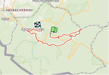
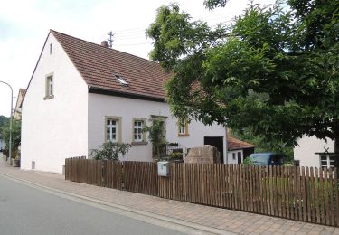
Trail On foot of 11.7 km to be discovered at Rhineland-Palatinate, Südwestpfalz, Eppenbrunn. This trail is proposed by SityTrail - itinéraires balisés pédestres.
Description
Trail created by PWV.
Symbol: Auf Buntsandsteinfels sitzende Eule
Positioning
Country:
Germany
Region :
Rhineland-Palatinate
Department/Province :
Südwestpfalz
Municipality :
Eppenbrunn
Location:
Unknown
Start:(Dec)
Start:(UTM)
396358 ; 5440746 (32U) N.
Comments
Trails nearby
![Trail Walking Roppeviller - Le rocher de l'Altschlossfelsen - Photo](https://media.geolcdn.com/t/375/260/ext.jpg?maxdim=2&url=https%3A%2F%2Fservices.sitytrail.com%2FGeolivesWS%2FDownloadMedia.ashx%3FTrailID%3D507904%26Media%3Dfix__20151230144825.jpg)
![Walking Walking](https://static1.geolcdn.com/sitytour/trail-icons/101.png)
Le rocher de l'Altschlossfelsen
Walking
Easy
(2)
Roppeviller,
Grand Est,
Moselle,
France
![](/images/other/stat-length.png)
13 km | 16.1 km-effort
3h 30min
![](https://static1.geolcdn.com/siteimages/upload/files/16400158638029165_repeat_loop_refresh_sync_direction_icon.png)
Yes
![Trail On foot Eppenbrunn - Rundwanderweg Eppenbrunn 4 - Photo](https://media.geolcdn.com/t/375/260/d76b12f8-9b11-4fdc-b6fb-e06d26791a08.jpeg&format=jpg&maxdim=2)
![On foot On foot](https://static1.geolcdn.com/sitytour/trail-icons/100.png)
Rundwanderweg Eppenbrunn 4
On foot
Easy
Eppenbrunn,
Rhineland-Palatinate,
Südwestpfalz,
Germany
![](/images/other/stat-length.png)
7 km | 9.3 km-effort
2h 7min
![](https://static1.geolcdn.com/siteimages/upload/files/16400158638029165_repeat_loop_refresh_sync_direction_icon.png)
Yes
![Trail On foot Eppenbrunn - Rundwanderweg Eppenbrunn 3 - Photo](https://media.geolcdn.com/t/375/260/8b8b2093-265c-4b8e-94ca-9cb59e68b168.jpeg&format=jpg&maxdim=2)
![On foot On foot](https://static1.geolcdn.com/sitytour/trail-icons/100.png)
Rundwanderweg Eppenbrunn 3
On foot
Easy
Eppenbrunn,
Rhineland-Palatinate,
Südwestpfalz,
Germany
![](/images/other/stat-length.png)
4.2 km | 5.8 km-effort
1h 18min
![](https://static1.geolcdn.com/siteimages/upload/files/16400158638029165_repeat_loop_refresh_sync_direction_icon.png)
No
![Trail On foot Eppenbrunn - Grenzweg - Photo](https://media.geolcdn.com/t/375/260/e479e6c8-b176-4dba-ba62-ac01003618c1.jpeg&format=jpg&maxdim=2)
![On foot On foot](https://static1.geolcdn.com/sitytour/trail-icons/100.png)
Grenzweg
On foot
Easy
Eppenbrunn,
Rhineland-Palatinate,
Südwestpfalz,
Germany
![](/images/other/stat-length.png)
11.3 km | 15 km-effort
3h 24min
![](https://static1.geolcdn.com/siteimages/upload/files/16400158638029165_repeat_loop_refresh_sync_direction_icon.png)
Yes
![Trail On foot Eppenbrunn - Altschloßpfad - Photo](https://media.geolcdn.com/t/375/260/a5395986-09d3-4d9b-b349-30e698a212eb.jpeg&format=jpg&maxdim=2)
![On foot On foot](https://static1.geolcdn.com/sitytour/trail-icons/100.png)
Altschloßpfad
On foot
Easy
Eppenbrunn,
Rhineland-Palatinate,
Südwestpfalz,
Germany
![](/images/other/stat-length.png)
10 km | 13.4 km-effort
3h 3min
![](https://static1.geolcdn.com/siteimages/upload/files/16400158638029165_repeat_loop_refresh_sync_direction_icon.png)
Yes
![Trail On foot Ludwigswinkel - Rumberg-Steig - Photo](https://media.geolcdn.com/t/375/260/5498a04f-ba6b-4345-82fb-7bd25f635273.jpeg&format=jpg&maxdim=2)
![On foot On foot](https://static1.geolcdn.com/sitytour/trail-icons/100.png)
Rumberg-Steig
On foot
Easy
Ludwigswinkel,
Rhineland-Palatinate,
Südwestpfalz,
Germany
![](/images/other/stat-length.png)
11.3 km | 15.2 km-effort
3h 27min
![](https://static1.geolcdn.com/siteimages/upload/files/16400158638029165_repeat_loop_refresh_sync_direction_icon.png)
Yes
![Trail On foot Eppenbrunn - Red dot - Photo](https://media.geolcdn.com/t/375/260/d76b12f8-9b11-4fdc-b6fb-e06d26791a08.jpeg&format=jpg&maxdim=2)
![On foot On foot](https://static1.geolcdn.com/sitytour/trail-icons/100.png)
Red dot
On foot
Easy
Eppenbrunn,
Rhineland-Palatinate,
Südwestpfalz,
Germany
![](/images/other/stat-length.png)
9.6 km | 12.9 km-effort
2h 55min
![](https://static1.geolcdn.com/siteimages/upload/files/16400158638029165_repeat_loop_refresh_sync_direction_icon.png)
No
![Trail Walking Roppeviller - Roppeviller - Photo](https://media.geolcdn.com/t/375/260/66cfb538-0dd2-4437-b13a-aee3911265be.jpg&format=jpg&maxdim=2)
![Walking Walking](https://static1.geolcdn.com/sitytour/trail-icons/101.png)
Roppeviller
Walking
Easy
Roppeviller,
Grand Est,
Moselle,
France
![](/images/other/stat-length.png)
6.6 km | 8.7 km-effort
2h 13min
![](https://static1.geolcdn.com/siteimages/upload/files/16400158638029165_repeat_loop_refresh_sync_direction_icon.png)
Yes
![Trail Walking Roppeviller - 20200627 - Photo](https://media.geolcdn.com/t/375/260/022911ec-f4bf-4905-b37e-579c3f57a55a.jpg&format=jpg&maxdim=2)
![Walking Walking](https://static1.geolcdn.com/sitytour/trail-icons/101.png)