![](/images/other/stat-length.png)
![Trail On foot Gevelsberg - Gevelsberg A2 - Photo](https://media.geolcdn.com/t/1900/400/ext.pjpeg?maxdim=2&url=https%3A%2F%2Fmedia.geolcdn.com%2Ff%2F21da2367-fb27-4e94-9be3-4f8ac0f58149.jpeg)
Gevelsberg A2
SityTrail - itinéraires balisés pédestres
Tous les sentiers balisés d’Europe PRO
![Length](/images/other/stat-length.png)
Length
5.4 km
![Max alt](https://static1.geolcdn.com/siteimages/upload/files/1508320355ic_sort_altitude_max_24dp.png)
Max alt
371 m
![Uphill gradient](https://static1.geolcdn.com/siteimages/upload/files/1508320355ic_sort_den_pos_24dp.png)
Uphill gradient
160 m
![Km-Effort](/images/other/stat-length.png)
Km-Effort
7.5 km
![Min alt](https://static1.geolcdn.com/siteimages/upload/files/1508320355ic_sort_altitude_min_24dp.png)
Min alt
245 m
![Downhill gradient](https://static1.geolcdn.com/siteimages/upload/files/1508320355ic_sort_den_neg_24dp.png)
Downhill gradient
152 m
![Boucle](https://static1.geolcdn.com/siteimages/upload/files/16400158638029165_repeat_loop_refresh_sync_direction_icon.png)
Boucle
Yes
Signpost
Creation date :
2022-02-11 20:13:29.015
Updated on :
2022-02-11 20:13:29.015
![On foot](https://static1.geolcdn.com/sitytour/trail-icons/100.png)
1h42
Difficulty : Easy
![Scan this QR Code to open this trail in the SityTrail application](https://capi.geolives.com/qq0zvz2zws4bq2lad0pu/sitytour/trails/3101565/qr.png?size=200)
FREE GPS app for hiking
About
Trail On foot of 5.4 km to be discovered at North Rhine-Westphalia, Ennepe-Ruhr-Kreis, Gevelsberg. This trail is proposed by SityTrail - itinéraires balisés pédestres.
Description
Trail created by Sauerländer Gebirgsverein.
Positioning
Country:
Germany
Region :
North Rhine-Westphalia
Department/Province :
Ennepe-Ruhr-Kreis
Municipality :
Gevelsberg
Location:
Unknown
Start:(Dec)
Start:(UTM)
384712 ; 5686161 (32U) N.
Comments
Trails nearby
![Trail On foot Ennepetal - GEV-Nirgena - EN-Voerde - EN-Ahlhausen - Photo](https://media.geolcdn.com/t/375/260/ext.jpg?maxdim=2&url=https%3A%2F%2Fmedia.geolcdn.com%2Ff%2Fda141f89-6e3f-4d71-b3a3-70cff173877e.jpeg)
![On foot On foot](https://static1.geolcdn.com/sitytour/trail-icons/100.png)
GEV-Nirgena - EN-Voerde - EN-Ahlhausen
On foot
Easy
Ennepetal,
North Rhine-Westphalia,
Ennepe-Ruhr-Kreis,
Germany
![](/images/other/stat-length.png)
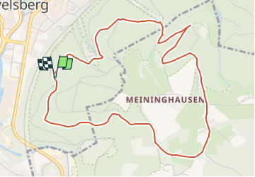
10.4 km | 14.3 km-effort
3h 15min
![](https://static1.geolcdn.com/siteimages/upload/files/16400158638029165_repeat_loop_refresh_sync_direction_icon.png)
No
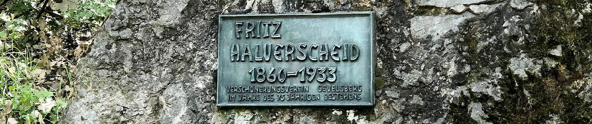
![Trail On foot Gevelsberg - [A3] historischer Rundwanderweg Silschede - Photo](https://media.geolcdn.com/t/375/260/ext.jpg?maxdim=2&url=https%3A%2F%2Fmedia.geolcdn.com%2Ff%2Fe8511c04-2680-4359-a7af-e8f515133e2a.jpeg)
![On foot On foot](https://static1.geolcdn.com/sitytour/trail-icons/100.png)
[A3] historischer Rundwanderweg Silschede
On foot
Easy
Gevelsberg,
North Rhine-Westphalia,
Ennepe-Ruhr-Kreis,
Germany
![](/images/other/stat-length.png)
4 km | 5.3 km-effort
1h 12min
![](https://static1.geolcdn.com/siteimages/upload/files/16400158638029165_repeat_loop_refresh_sync_direction_icon.png)
Yes
![Trail On foot Gevelsberg - [A2] Rundwanderweg Silschede - Photo](https://media.geolcdn.com/t/375/260/ext.jpg?maxdim=2&url=https%3A%2F%2Fmedia.geolcdn.com%2Ff%2Fe8511c04-2680-4359-a7af-e8f515133e2a.jpeg)
![On foot On foot](https://static1.geolcdn.com/sitytour/trail-icons/100.png)
[A2] Rundwanderweg Silschede
On foot
Easy
Gevelsberg,
North Rhine-Westphalia,
Ennepe-Ruhr-Kreis,
Germany
![](/images/other/stat-length.png)
7.1 km | 9 km-effort
2h 2min
![](https://static1.geolcdn.com/siteimages/upload/files/16400158638029165_repeat_loop_refresh_sync_direction_icon.png)
Yes
![Trail On foot Ennepetal - Voerde Rundweg A7 - Photo](https://media.geolcdn.com/t/375/260/ext.jpg?maxdim=2&url=https%3A%2F%2Fmedia.geolcdn.com%2Ff%2F06f812dd-828f-4932-abc8-6edb7058f4bf.jpeg)
![On foot On foot](https://static1.geolcdn.com/sitytour/trail-icons/100.png)
Voerde Rundweg A7
On foot
Easy
Ennepetal,
North Rhine-Westphalia,
Ennepe-Ruhr-Kreis,
Germany
![](/images/other/stat-length.png)
5.2 km | 6.8 km-effort
1h 33min
![](https://static1.geolcdn.com/siteimages/upload/files/16400158638029165_repeat_loop_refresh_sync_direction_icon.png)
No
![Trail On foot Gevelsberg - Wanderweg Gevelsberg-Silschede - Photo](https://media.geolcdn.com/t/375/260/ext.jpg?maxdim=2&url=https%3A%2F%2Fmedia.geolcdn.com%2Ff%2Fe8511c04-2680-4359-a7af-e8f515133e2a.jpeg)
![On foot On foot](https://static1.geolcdn.com/sitytour/trail-icons/100.png)
Wanderweg Gevelsberg-Silschede
On foot
Easy
Gevelsberg,
North Rhine-Westphalia,
Ennepe-Ruhr-Kreis,
Germany
![](/images/other/stat-length.png)
11.5 km | 14.7 km-effort
3h 20min
![](https://static1.geolcdn.com/siteimages/upload/files/16400158638029165_repeat_loop_refresh_sync_direction_icon.png)
No
![Trail On foot Gevelsberg - Forsthaus Rundweg A3 - Photo](https://media.geolcdn.com/t/375/260/ext.jpg?maxdim=2&url=https%3A%2F%2Fmedia.geolcdn.com%2Ff%2F21da2367-fb27-4e94-9be3-4f8ac0f58149.jpeg)
![On foot On foot](https://static1.geolcdn.com/sitytour/trail-icons/100.png)
Forsthaus Rundweg A3
On foot
Easy
Gevelsberg,
North Rhine-Westphalia,
Ennepe-Ruhr-Kreis,
Germany
![](/images/other/stat-length.png)
7.4 km | 10.4 km-effort
2h 21min
![](https://static1.geolcdn.com/siteimages/upload/files/16400158638029165_repeat_loop_refresh_sync_direction_icon.png)
Yes
![Trail On foot Gevelsberg - Aske Rundweg A4 - Photo](https://media.geolcdn.com/t/375/260/ext.jpg?maxdim=2&url=https%3A%2F%2Fmedia.geolcdn.com%2Ff%2F1594bd41-9524-43ca-85b5-86379e23f07a.jpeg)
![On foot On foot](https://static1.geolcdn.com/sitytour/trail-icons/100.png)
Aske Rundweg A4
On foot
Easy
Gevelsberg,
North Rhine-Westphalia,
Ennepe-Ruhr-Kreis,
Germany
![](/images/other/stat-length.png)
4.1 km | 5.5 km-effort
1h 14min
![](https://static1.geolcdn.com/siteimages/upload/files/16400158638029165_repeat_loop_refresh_sync_direction_icon.png)
Yes
![Trail On foot Schwelm - Rüggeberg-Beyenburg - Photo](https://media.geolcdn.com/t/375/260/ext.jpg?maxdim=2&url=https%3A%2F%2Fmedia.geolcdn.com%2Ff%2F02b123f2-cce4-4e86-b142-598c3c9f678e.jpeg)
![On foot On foot](https://static1.geolcdn.com/sitytour/trail-icons/100.png)
Rüggeberg-Beyenburg
On foot
Easy
Schwelm,
North Rhine-Westphalia,
Ennepe-Ruhr-Kreis,
Germany
![](/images/other/stat-length.png)
4.8 km | 6.6 km-effort
1h 29min
![](https://static1.geolcdn.com/siteimages/upload/files/16400158638029165_repeat_loop_refresh_sync_direction_icon.png)
No
![Trail On foot Schwelm - (S) Schwelmer Rundweg - Photo](https://media.geolcdn.com/t/375/260/ext.jpg?maxdim=2&url=https%3A%2F%2Fmedia.geolcdn.com%2Ff%2Fa0c52fd2-dba0-467a-8fe3-93e4017dae9b.jpeg)
![On foot On foot](https://static1.geolcdn.com/sitytour/trail-icons/100.png)
(S) Schwelmer Rundweg
On foot
Medium
Schwelm,
North Rhine-Westphalia,
Ennepe-Ruhr-Kreis,
Germany
![](/images/other/stat-length.png)
22 km | 28 km-effort
6h 27min
![](https://static1.geolcdn.com/siteimages/upload/files/16400158638029165_repeat_loop_refresh_sync_direction_icon.png)
Yes