![](/images/other/stat-length.png)
![Trail On foot Asbach - [A1] Basaltweg - Photo](https://media.geolcdn.com/t/1900/400/ext.pjpeg?maxdim=2&url=https%3A%2F%2Fmedia.geolcdn.com%2Ff%2F17f9fb3a-b4a7-45d7-a2b4-ea773ee9f1e5.jpeg)
[A1] Basaltweg
SityTrail - itinéraires balisés pédestres
Tous les sentiers balisés d’Europe PRO
![Length](/images/other/stat-length.png)
Length
10.1 km
![Max alt](https://static1.geolcdn.com/siteimages/upload/files/1508320355ic_sort_altitude_max_24dp.png)
Max alt
316 m
![Uphill gradient](https://static1.geolcdn.com/siteimages/upload/files/1508320355ic_sort_den_pos_24dp.png)
Uphill gradient
115 m
![Km-Effort](/images/other/stat-length.png)
Km-Effort
11.6 km
![Min alt](https://static1.geolcdn.com/siteimages/upload/files/1508320355ic_sort_altitude_min_24dp.png)
Min alt
228 m
![Downhill gradient](https://static1.geolcdn.com/siteimages/upload/files/1508320355ic_sort_den_neg_24dp.png)
Downhill gradient
114 m
![Boucle](https://static1.geolcdn.com/siteimages/upload/files/16400158638029165_repeat_loop_refresh_sync_direction_icon.png)
Boucle
Yes
Signpost
Creation date :
2022-02-11 19:59:03.734
Updated on :
2022-02-11 19:59:03.734
![On foot](https://static1.geolcdn.com/sitytour/trail-icons/100.png)
2h38
Difficulty : Easy
![Scan this QR Code to open this trail in the SityTrail application](https://capi.geolives.com/qq0zvz2zws4bq2lad0pu/sitytour/trails/3101279/qr.png?size=200)
FREE GPS app for hiking
About
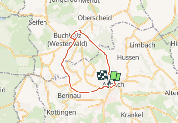
Trail On foot of 10.1 km to be discovered at Rhineland-Palatinate, Landkreis Neuwied, Asbach. This trail is proposed by SityTrail - itinéraires balisés pédestres.
Description
Trail created by Verbandsgemeinde Asbach.
Symbol: Weißer Text A1 auf rotem Grund
Positioning
Country:
Germany
Region :
Rhineland-Palatinate
Department/Province :
Landkreis Neuwied
Municipality :
Asbach
Location:
Unknown
Start:(Dec)
Start:(UTM)
388425 ; 5613869 (32U) N.
Comments
Trails nearby
![Trail On foot Windhagen - [W2] Windhagener Weg - Photo](https://media.geolcdn.com/t/375/260/ext.jpg?maxdim=2&url=https%3A%2F%2Fmedia.geolcdn.com%2Ff%2Fadef9696-6d08-4cbb-94cd-bba75114ff6a.jpeg)
![On foot On foot](https://static1.geolcdn.com/sitytour/trail-icons/100.png)
[W2] Windhagener Weg
On foot
Easy
Windhagen,
Rhineland-Palatinate,
Landkreis Neuwied,
Germany
![](/images/other/stat-length.png)
6.9 km | 8.8 km-effort
1h 59min
![](https://static1.geolcdn.com/siteimages/upload/files/16400158638029165_repeat_loop_refresh_sync_direction_icon.png)
Yes
![Trail On foot Asbach - [A4] Mühlenweg - Photo](https://media.geolcdn.com/t/375/260/ext.jpg?maxdim=2&url=https%3A%2F%2Fmedia.geolcdn.com%2Ff%2F17f9fb3a-b4a7-45d7-a2b4-ea773ee9f1e5.jpeg)
![On foot On foot](https://static1.geolcdn.com/sitytour/trail-icons/100.png)
[A4] Mühlenweg
On foot
Easy
Asbach,
Rhineland-Palatinate,
Landkreis Neuwied,
Germany
![](/images/other/stat-length.png)
12.8 km | 16.2 km-effort
3h 40min
![](https://static1.geolcdn.com/siteimages/upload/files/16400158638029165_repeat_loop_refresh_sync_direction_icon.png)
Yes
![Trail On foot Asbach - [A3] Kirchspielweg - Photo](https://media.geolcdn.com/t/375/260/ext.jpg?maxdim=2&url=https%3A%2F%2Fmedia.geolcdn.com%2Ff%2F17f9fb3a-b4a7-45d7-a2b4-ea773ee9f1e5.jpeg)
![On foot On foot](https://static1.geolcdn.com/sitytour/trail-icons/100.png)
[A3] Kirchspielweg
On foot
Easy
Asbach,
Rhineland-Palatinate,
Landkreis Neuwied,
Germany
![](/images/other/stat-length.png)
13.2 km | 16.6 km-effort
3h 45min
![](https://static1.geolcdn.com/siteimages/upload/files/16400158638029165_repeat_loop_refresh_sync_direction_icon.png)
Yes
![Trail On foot Buchholz (Westerwald) - [B2] Dreiherrensteinweg - Photo](https://media.geolcdn.com/t/375/260/ext.jpg?maxdim=2&url=https%3A%2F%2Fmedia.geolcdn.com%2Ff%2Faecd4644-6921-4b4a-8659-a9cc70680b9b.jpeg)
![On foot On foot](https://static1.geolcdn.com/sitytour/trail-icons/100.png)
[B2] Dreiherrensteinweg
On foot
Easy
Buchholz (Westerwald),
Rhineland-Palatinate,
Landkreis Neuwied,
Germany
![](/images/other/stat-length.png)
12.4 km | 14.8 km-effort
3h 22min
![](https://static1.geolcdn.com/siteimages/upload/files/16400158638029165_repeat_loop_refresh_sync_direction_icon.png)
Yes
![Trail On foot Buchholz (Westerwald) - [B3] Silberbergweg - Photo](https://media.geolcdn.com/t/375/260/ext.jpg?maxdim=2&url=https%3A%2F%2Fmedia.geolcdn.com%2Ff%2F26598f31-7aa1-441d-a048-772ec0888cec.jpeg)
![On foot On foot](https://static1.geolcdn.com/sitytour/trail-icons/100.png)
[B3] Silberbergweg
On foot
Easy
Buchholz (Westerwald),
Rhineland-Palatinate,
Landkreis Neuwied,
Germany
![](/images/other/stat-length.png)
11.1 km | 13.9 km-effort
3h 10min
![](https://static1.geolcdn.com/siteimages/upload/files/16400158638029165_repeat_loop_refresh_sync_direction_icon.png)
Yes
![Trail On foot Neustadt (Wied) - N3 Neustädter Wanderweg 3 - Photo](https://media.geolcdn.com/t/375/260/ext.jpg?maxdim=2&url=https%3A%2F%2Fmedia.geolcdn.com%2Ff%2Fe89ca6e9-1f21-4815-a33f-c9a8d227dac0.jpeg)
![On foot On foot](https://static1.geolcdn.com/sitytour/trail-icons/100.png)
N3 Neustädter Wanderweg 3
On foot
Easy
Neustadt (Wied),
Rhineland-Palatinate,
Landkreis Neuwied,
Germany
![](/images/other/stat-length.png)
10.7 km | 14.2 km-effort
3h 13min
![](https://static1.geolcdn.com/siteimages/upload/files/16400158638029165_repeat_loop_refresh_sync_direction_icon.png)
Yes
![Trail On foot Windhagen - [W1] Stockhauser Weg - Photo](https://media.geolcdn.com/t/375/260/ext.jpg?maxdim=2&url=https%3A%2F%2Fmedia.geolcdn.com%2Ff%2Fadef9696-6d08-4cbb-94cd-bba75114ff6a.jpeg)
![On foot On foot](https://static1.geolcdn.com/sitytour/trail-icons/100.png)
[W1] Stockhauser Weg
On foot
Easy
Windhagen,
Rhineland-Palatinate,
Landkreis Neuwied,
Germany
![](/images/other/stat-length.png)
8.6 km | 11 km-effort
2h 30min
![](https://static1.geolcdn.com/siteimages/upload/files/16400158638029165_repeat_loop_refresh_sync_direction_icon.png)
Yes
![Trail On foot Asbach - [B1] Barger Heck Weg - Photo](https://media.geolcdn.com/t/375/260/ext.jpg?maxdim=2&url=https%3A%2F%2Fstatic1.geolcdn.com%2Fsiteimages%2Fupload%2Ffiles%2F1545311037marcheuse_200dpi.jpg)
![On foot On foot](https://static1.geolcdn.com/sitytour/trail-icons/100.png)
[B1] Barger Heck Weg
On foot
Easy
Asbach,
Rhineland-Palatinate,
Landkreis Neuwied,
Germany
![](/images/other/stat-length.png)
11.6 km | 13.9 km-effort
3h 8min
![](https://static1.geolcdn.com/siteimages/upload/files/16400158638029165_repeat_loop_refresh_sync_direction_icon.png)
Yes
![Trail On foot Neustadt (Wied) - Bühlinger Weg - Photo](https://media.geolcdn.com/t/375/260/ext.jpg?maxdim=2&url=https%3A%2F%2Fstatic1.geolcdn.com%2Fsiteimages%2Fupload%2Ffiles%2F1545311037marcheuse_200dpi.jpg)
![On foot On foot](https://static1.geolcdn.com/sitytour/trail-icons/100.png)
Bühlinger Weg
On foot
Easy
Neustadt (Wied),
Rhineland-Palatinate,
Landkreis Neuwied,
Germany
![](/images/other/stat-length.png)
8.9 km | 11.5 km-effort
2h 36min
![](https://static1.geolcdn.com/siteimages/upload/files/16400158638029165_repeat_loop_refresh_sync_direction_icon.png)
Yes