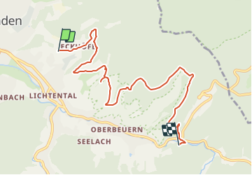
![](/images/other/stat-length.png)
![Trail On foot Unknown - Panoramaweg - Etappe 2 - Photo](https://media.geolcdn.com/t/1900/400/772f91b0-f13c-4626-b3a1-146449a3abc4.jpeg&format=pjpeg&maxdim=2)
Panoramaweg - Etappe 2
SityTrail - itinéraires balisés pédestres
Tous les sentiers balisés d’Europe GUIDE+
![Length](/images/other/stat-length.png)
![Max alt](https://static1.geolcdn.com/siteimages/upload/files/1508320355ic_sort_altitude_max_24dp.png)
![Uphill gradient](https://static1.geolcdn.com/siteimages/upload/files/1508320355ic_sort_den_pos_24dp.png)
![Km-Effort](/images/other/stat-length.png)
![Min alt](https://static1.geolcdn.com/siteimages/upload/files/1508320355ic_sort_altitude_min_24dp.png)
![Downhill gradient](https://static1.geolcdn.com/siteimages/upload/files/1508320355ic_sort_den_neg_24dp.png)
![Boucle](https://static1.geolcdn.com/siteimages/upload/files/16400158638029165_repeat_loop_refresh_sync_direction_icon.png)
![On foot](https://static1.geolcdn.com/sitytour/trail-icons/100.png)
2h26
Difficulty : Easy
![Scan this QR Code to open this trail in the SityTrail application](https://capi.geolives.com/qq0zvz2zws4bq2lad0pu/sitytour/trails/3101019/qr.png?size=200)
FREE GPS app for hiking
About
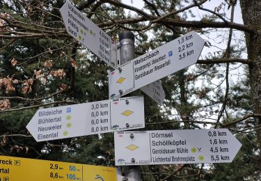
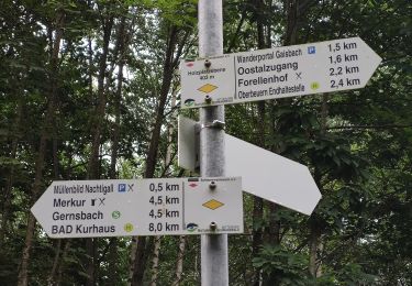
Trail On foot of 7.8 km to be discovered at Baden-Württemberg, Baden-Baden. This trail is proposed by SityTrail - itinéraires balisés pédestres.
Description
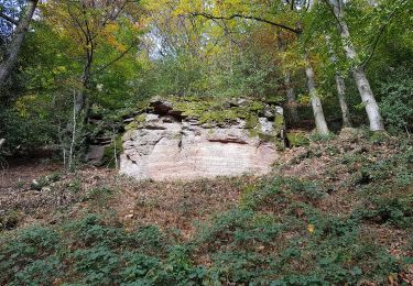
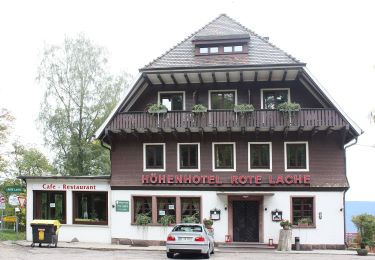
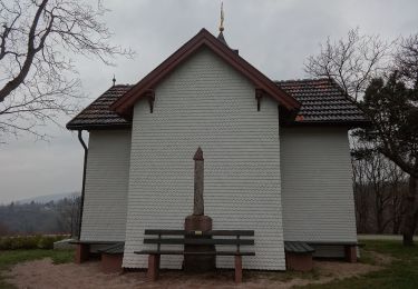
Idyllische Streuobstwiesen, malerische Aussichten, Begegnungen mit friedlich weidenden Hochlandrindern – Bilderbuchlandschaften auf der zweiten Etappe des Panoramawegs.
Website: https://visit.baden-baden.de/media/touren/panoramaweg-etappe-2-merkurbergbahn-zum-forellenhof
Positioning
Comments
Trails nearby
![Trail On foot - Kreuzfelsen-Rundweg - Photo](https://media.geolcdn.com/t/375/260/f9dace17-edc3-438b-97fc-f5c4b4d7572a.jpeg&format=jpg&maxdim=2)
![On foot On foot](https://static1.geolcdn.com/sitytour/trail-icons/100.png)
On foot
![](/images/other/stat-length.png)
![](https://static1.geolcdn.com/siteimages/upload/files/16400158638029165_repeat_loop_refresh_sync_direction_icon.png)
![Trail On foot - Einmündung Littersbach - Bernickel - Photo](https://media.geolcdn.com/t/375/260/bea8d541-e7ea-450b-a556-e23b7df34437.jpeg&format=jpg&maxdim=2)
![On foot On foot](https://static1.geolcdn.com/sitytour/trail-icons/100.png)
On foot
![](/images/other/stat-length.png)
![](https://static1.geolcdn.com/siteimages/upload/files/16400158638029165_repeat_loop_refresh_sync_direction_icon.png)
![Trail On foot - Ebersteinburg-Rundweg - Photo](https://media.geolcdn.com/t/375/260/f643df66-7945-4966-9111-c1873db1eaf8.jpeg&format=jpg&maxdim=2)
![On foot On foot](https://static1.geolcdn.com/sitytour/trail-icons/100.png)
On foot
![](/images/other/stat-length.png)
![](https://static1.geolcdn.com/siteimages/upload/files/16400158638029165_repeat_loop_refresh_sync_direction_icon.png)
![Trail On foot - Zimmerplatz - Bildeiche - Photo](https://media.geolcdn.com/t/375/260/d36c0341-f6bb-4a42-a8d2-35e91d9bea23.jpeg&format=jpg&maxdim=2)
![On foot On foot](https://static1.geolcdn.com/sitytour/trail-icons/100.png)
On foot
![](/images/other/stat-length.png)
![](https://static1.geolcdn.com/siteimages/upload/files/16400158638029165_repeat_loop_refresh_sync_direction_icon.png)
![Trail On foot - Oostalzugang Ost - Rote Lache - Photo](https://media.geolcdn.com/t/375/260/a590b01a-ee10-4d9f-beb6-8980dc73ca0d.jpeg&format=jpg&maxdim=2)
![On foot On foot](https://static1.geolcdn.com/sitytour/trail-icons/100.png)
On foot
![](/images/other/stat-length.png)
![](https://static1.geolcdn.com/siteimages/upload/files/16400158638029165_repeat_loop_refresh_sync_direction_icon.png)
![Trail On foot - Oostal Rundweg - Photo](https://media.geolcdn.com/t/375/260/f6dc3586-d17b-471d-9820-7fdb503f90c7.jpeg&format=jpg&maxdim=2)
![On foot On foot](https://static1.geolcdn.com/sitytour/trail-icons/100.png)
On foot
![](/images/other/stat-length.png)
![](https://static1.geolcdn.com/siteimages/upload/files/16400158638029165_repeat_loop_refresh_sync_direction_icon.png)
![Trail On foot - Rehgarten Rundweg - Photo](https://media.geolcdn.com/t/375/260/bab156c0-31c8-4076-8528-62ab4461ec9b.jpeg&format=jpg&maxdim=2)
![On foot On foot](https://static1.geolcdn.com/sitytour/trail-icons/100.png)
On foot
![](/images/other/stat-length.png)
![](https://static1.geolcdn.com/siteimages/upload/files/16400158638029165_repeat_loop_refresh_sync_direction_icon.png)
![Trail On foot - Weinweg Eckberg/Schafberg - Photo](https://media.geolcdn.com/t/375/260/772f91b0-f13c-4626-b3a1-146449a3abc4.jpeg&format=jpg&maxdim=2)
![On foot On foot](https://static1.geolcdn.com/sitytour/trail-icons/100.png)
On foot
![](/images/other/stat-length.png)
![](https://static1.geolcdn.com/siteimages/upload/files/16400158638029165_repeat_loop_refresh_sync_direction_icon.png)
![Trail On foot - Panoramaweg - Etappe 3 - Photo](https://media.geolcdn.com/t/375/260/bab156c0-31c8-4076-8528-62ab4461ec9b.jpeg&format=jpg&maxdim=2)
![On foot On foot](https://static1.geolcdn.com/sitytour/trail-icons/100.png)
On foot
![](/images/other/stat-length.png)
![](https://static1.geolcdn.com/siteimages/upload/files/16400158638029165_repeat_loop_refresh_sync_direction_icon.png)