![](/images/other/stat-length.png)
![Trail On foot Darscheid - HeimatSpur Pfad der Artenvielfalt - Photo](https://media.geolcdn.com/t/1900/400/46945c2e-932f-4377-b136-a41388844541.jpeg&format=pjpeg&maxdim=2)
HeimatSpur Pfad der Artenvielfalt
SityTrail - itinéraires balisés pédestres
Tous les sentiers balisés d’Europe GUIDE+
![Length](/images/other/stat-length.png)
Length
10.8 km
![Max alt](https://static1.geolcdn.com/siteimages/upload/files/1508320355ic_sort_altitude_max_24dp.png)
Max alt
544 m
![Uphill gradient](https://static1.geolcdn.com/siteimages/upload/files/1508320355ic_sort_den_pos_24dp.png)
Uphill gradient
198 m
![Km-Effort](/images/other/stat-length.png)
Km-Effort
13.6 km
![Min alt](https://static1.geolcdn.com/siteimages/upload/files/1508320355ic_sort_altitude_min_24dp.png)
Min alt
441 m
![Downhill gradient](https://static1.geolcdn.com/siteimages/upload/files/1508320355ic_sort_den_neg_24dp.png)
Downhill gradient
246 m
![Boucle](https://static1.geolcdn.com/siteimages/upload/files/16400158638029165_repeat_loop_refresh_sync_direction_icon.png)
Boucle
No
Signpost
Creation date :
2022-02-11 19:37:19.616
Updated on :
2022-02-11 19:37:19.616
![On foot](https://static1.geolcdn.com/sitytour/trail-icons/100.png)
3h05
Difficulty : Easy
![Scan this QR Code to open this trail in the SityTrail application](https://capi.geolives.com/qq0zvz2zws4bq2lad0pu/sitytour/trails/3100896/qr.png?size=200)
FREE GPS app for hiking
About
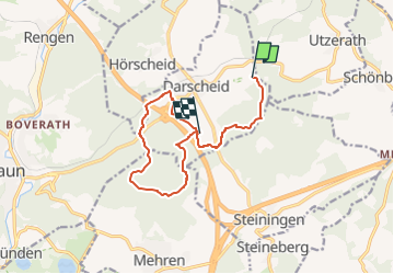
Trail On foot of 10.8 km to be discovered at Rhineland-Palatinate, Landkreis Vulkaneifel, Darscheid. This trail is proposed by SityTrail - itinéraires balisés pédestres.
Description
Trail created by Natur-Erlebnis-Zentrum Darscheid.
Symbol: Rote Eule
Website: http://www.darscheid.nez-vulkaneifel.de/index.php/projekte/pfad-der-artenvielfalt
Positioning
Country:
Germany
Region :
Rhineland-Palatinate
Department/Province :
Landkreis Vulkaneifel
Municipality :
Darscheid
Location:
Unknown
Start:(Dec)
Start:(UTM)
350754 ; 5564617 (32U) N.
Comments
Trails nearby
![Trail On foot Steineberg - HeimatSpur Keltenrundweg - Photo](https://media.geolcdn.com/t/375/260/4b1692aa-f11b-4d67-8202-607607da5a44.jpeg&format=jpg&maxdim=2)
![On foot On foot](https://static1.geolcdn.com/sitytour/trail-icons/100.png)
HeimatSpur Keltenrundweg
On foot
Medium
Steineberg,
Rhineland-Palatinate,
Landkreis Vulkaneifel,
Germany
![](/images/other/stat-length.png)
15.4 km | 20 km-effort
4h 36min
![](https://static1.geolcdn.com/siteimages/upload/files/16400158638029165_repeat_loop_refresh_sync_direction_icon.png)
Yes
![Trail Walking Schalkenmehren - VulkanEifel Daun - Photo](https://media.geolcdn.com/t/375/260/24cfb6ee-d49a-4054-9e4b-9172f2529c75.jpg&format=jpg&maxdim=2)
![Walking Walking](https://static1.geolcdn.com/sitytour/trail-icons/101.png)
VulkanEifel Daun
Walking
Medium
Schalkenmehren,
Rhineland-Palatinate,
Landkreis Vulkaneifel,
Germany
![](/images/other/stat-length.png)
3.5 km | 4.7 km-effort
1h 55min
![](https://static1.geolcdn.com/siteimages/upload/files/16400158638029165_repeat_loop_refresh_sync_direction_icon.png)
Yes
![Trail Walking Schalkenmehren - 30 juin Boucle Wein Felder Maar - Photo](https://media.geolcdn.com/t/375/260/ext.jpg?maxdim=2&url=https%3A%2F%2Fstatic1.geolcdn.com%2Fsiteimages%2Fupload%2Ffiles%2F1553511878bg_sport_marche.png)
![Walking Walking](https://static1.geolcdn.com/sitytour/trail-icons/101.png)
30 juin Boucle Wein Felder Maar
Walking
Very difficult
Schalkenmehren,
Rhineland-Palatinate,
Landkreis Vulkaneifel,
Germany
![](/images/other/stat-length.png)
16 km | 22 km-effort
4h 54min
![](https://static1.geolcdn.com/siteimages/upload/files/16400158638029165_repeat_loop_refresh_sync_direction_icon.png)
Yes