![](/images/other/stat-length.png)
![Trail On foot Furth im Wald - Fu02 Drachensee-Rundweg - Photo](https://media.geolcdn.com/t/1900/400/48f4cb4c-aa2a-4077-9fde-0c09a0ffc5d6.jpeg&format=pjpeg&maxdim=2)
Fu02 Drachensee-Rundweg
SityTrail - itinéraires balisés pédestres
Tous les sentiers balisés d’Europe GUIDE+
![Length](/images/other/stat-length.png)
Length
9.4 km
![Max alt](https://static1.geolcdn.com/siteimages/upload/files/1508320355ic_sort_altitude_max_24dp.png)
Max alt
459 m
![Uphill gradient](https://static1.geolcdn.com/siteimages/upload/files/1508320355ic_sort_den_pos_24dp.png)
Uphill gradient
138 m
![Km-Effort](/images/other/stat-length.png)
Km-Effort
11.2 km
![Min alt](https://static1.geolcdn.com/siteimages/upload/files/1508320355ic_sort_altitude_min_24dp.png)
Min alt
398 m
![Downhill gradient](https://static1.geolcdn.com/siteimages/upload/files/1508320355ic_sort_den_neg_24dp.png)
Downhill gradient
139 m
![Boucle](https://static1.geolcdn.com/siteimages/upload/files/16400158638029165_repeat_loop_refresh_sync_direction_icon.png)
Boucle
Yes
Signpost
Creation date :
2022-02-11 19:32:46.714
Updated on :
2022-02-11 19:32:46.714
![On foot](https://static1.geolcdn.com/sitytour/trail-icons/100.png)
2h33
Difficulty : Easy
![Scan this QR Code to open this trail in the SityTrail application](https://capi.geolives.com/qq0zvz2zws4bq2lad0pu/sitytour/trails/3100798/qr.png?size=200)
FREE GPS app for hiking
About
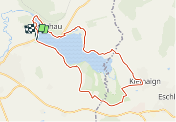
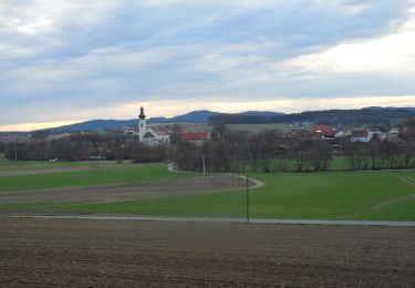
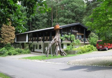
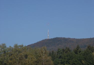
Trail On foot of 9.4 km to be discovered at Bavaria, Landkreis Cham, Furth im Wald. This trail is proposed by SityTrail - itinéraires balisés pédestres.
Description
Trail created by ARGE Further Wanderwege.
Symbol: rot F02 auf Weiß, darunter rot
Positioning
Country:
Germany
Region :
Bavaria
Department/Province :
Landkreis Cham
Municipality :
Furth im Wald
Location:
Unknown
Start:(Dec)
Start:(UTM)
345038 ; 5464370 (33U) N.
Comments
Trails nearby
![Trail On foot Furth im Wald - Goldsteig Verbindungsweg Furth im Wald - Domažlice - Photo](https://media.geolcdn.com/t/375/260/60a477b6-95cf-4661-b49b-f07c7a68b041.jpeg&format=jpg&maxdim=2)
![On foot On foot](https://static1.geolcdn.com/sitytour/trail-icons/100.png)
Goldsteig Verbindungsweg Furth im Wald - Domažlice
On foot
Medium
Furth im Wald,
Bavaria,
Landkreis Cham,
Germany
![](/images/other/stat-length.png)
19 km | 26 km-effort
5h 50min
![](https://static1.geolcdn.com/siteimages/upload/files/16400158638029165_repeat_loop_refresh_sync_direction_icon.png)
No
![Trail On foot Česká Kubice - CZ-6698 - Photo](https://media.geolcdn.com/t/375/260/e2a7427b-6ced-428e-80d9-cf9d0fd7903c.jpeg&format=jpg&maxdim=2)
![On foot On foot](https://static1.geolcdn.com/sitytour/trail-icons/100.png)
CZ-6698
On foot
Easy
Česká Kubice,
Southwest,
Plzeňský kraj,
Czech Republic
![](/images/other/stat-length.png)
5.1 km | 8.4 km-effort
1h 55min
![](https://static1.geolcdn.com/siteimages/upload/files/16400158638029165_repeat_loop_refresh_sync_direction_icon.png)
No
![Trail On foot Furth im Wald - Fu61 (Daberger Rundweg) - Photo](https://media.geolcdn.com/t/375/260/60c41f63-9e32-418a-93ca-fb61973d7b29.jpeg&format=jpg&maxdim=2)
![On foot On foot](https://static1.geolcdn.com/sitytour/trail-icons/100.png)
Fu61 (Daberger Rundweg)
On foot
Easy
Furth im Wald,
Bavaria,
Landkreis Cham,
Germany
![](/images/other/stat-length.png)
10.4 km | 13.1 km-effort
2h 58min
![](https://static1.geolcdn.com/siteimages/upload/files/16400158638029165_repeat_loop_refresh_sync_direction_icon.png)
No
![Trail On foot Furth im Wald - Fu11 »Hammerschmiedeweg« (Furth im Wald) - Photo](https://media.geolcdn.com/t/375/260/cdbb5a43-9cac-40d7-b43c-e7a2012f82b2.jpeg&format=jpg&maxdim=2)
![On foot On foot](https://static1.geolcdn.com/sitytour/trail-icons/100.png)
Fu11 »Hammerschmiedeweg« (Furth im Wald)
On foot
Easy
Furth im Wald,
Bavaria,
Landkreis Cham,
Germany
![](/images/other/stat-length.png)
8.3 km | 10.7 km-effort
2h 25min
![](https://static1.geolcdn.com/siteimages/upload/files/16400158638029165_repeat_loop_refresh_sync_direction_icon.png)
Yes
![Trail On foot Furth im Wald - Fu05 Arnschwanger Weg - Photo](https://media.geolcdn.com/t/375/260/352f0aa5-db68-4e23-babc-b1d03c091cf4.jpeg&format=jpg&maxdim=2)
![On foot On foot](https://static1.geolcdn.com/sitytour/trail-icons/100.png)
Fu05 Arnschwanger Weg
On foot
Easy
Furth im Wald,
Bavaria,
Landkreis Cham,
Germany
![](/images/other/stat-length.png)
8.8 km | 11.8 km-effort
2h 41min
![](https://static1.geolcdn.com/siteimages/upload/files/16400158638029165_repeat_loop_refresh_sync_direction_icon.png)
No
![Trail On foot Furth im Wald - Fu04 Steinbruchseeweg - Photo](https://media.geolcdn.com/t/375/260/457098b4-ffd5-4d32-ac88-228ffbf0283a.jpeg&format=jpg&maxdim=2)
![On foot On foot](https://static1.geolcdn.com/sitytour/trail-icons/100.png)
Fu04 Steinbruchseeweg
On foot
Easy
Furth im Wald,
Bavaria,
Landkreis Cham,
Germany
![](/images/other/stat-length.png)
5.6 km | 7.8 km-effort
1h 45min
![](https://static1.geolcdn.com/siteimages/upload/files/16400158638029165_repeat_loop_refresh_sync_direction_icon.png)
No
![Trail On foot Furth im Wald - Fu03 Hohenbogenweg - Photo](https://media.geolcdn.com/t/375/260/3c4f947b-7ce4-437f-ba58-8a2d63e6bc8c.jpeg&format=jpg&maxdim=2)
![On foot On foot](https://static1.geolcdn.com/sitytour/trail-icons/100.png)
Fu03 Hohenbogenweg
On foot
Difficult
Furth im Wald,
Bavaria,
Landkreis Cham,
Germany
![](/images/other/stat-length.png)
21 km | 31 km-effort
7h 3min
![](https://static1.geolcdn.com/siteimages/upload/files/16400158638029165_repeat_loop_refresh_sync_direction_icon.png)
Yes
![Trail On foot Arnschwang - As03 (Kalkofenrundweg, Arnschwang) - Photo](https://media.geolcdn.com/t/375/260/352f0aa5-db68-4e23-babc-b1d03c091cf4.jpeg&format=jpg&maxdim=2)
![On foot On foot](https://static1.geolcdn.com/sitytour/trail-icons/100.png)
As03 (Kalkofenrundweg, Arnschwang)
On foot
Easy
Arnschwang,
Bavaria,
Landkreis Cham,
Germany
![](/images/other/stat-length.png)
11.7 km | 16 km-effort
3h 38min
![](https://static1.geolcdn.com/siteimages/upload/files/16400158638029165_repeat_loop_refresh_sync_direction_icon.png)
Yes
![Trail On foot Arnschwang - As02 (Kapellenweg, Arnschwang) - Photo](https://media.geolcdn.com/t/375/260/352f0aa5-db68-4e23-babc-b1d03c091cf4.jpeg&format=jpg&maxdim=2)
![On foot On foot](https://static1.geolcdn.com/sitytour/trail-icons/100.png)
As02 (Kapellenweg, Arnschwang)
On foot
Easy
Arnschwang,
Bavaria,
Landkreis Cham,
Germany
![](/images/other/stat-length.png)
4.7 km | 6.7 km-effort
1h 30min
![](https://static1.geolcdn.com/siteimages/upload/files/16400158638029165_repeat_loop_refresh_sync_direction_icon.png)
No