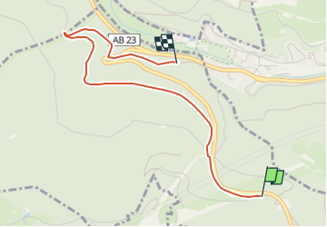
![](/images/other/stat-length.png)
![Trail On foot Forst Hain im Spessart - Kulturweg Spessartrampe - Photo](https://media.geolcdn.com/t/1900/400/524443bd-5349-4fdf-9da2-e9baf5eaf326.jpeg&format=pjpeg&maxdim=2)
Kulturweg Spessartrampe
SityTrail - itinéraires balisés pédestres
Tous les sentiers balisés d’Europe GUIDE+
![Length](/images/other/stat-length.png)
![Max alt](https://static1.geolcdn.com/siteimages/upload/files/1508320355ic_sort_altitude_max_24dp.png)
![Uphill gradient](https://static1.geolcdn.com/siteimages/upload/files/1508320355ic_sort_den_pos_24dp.png)
![Km-Effort](/images/other/stat-length.png)
![Min alt](https://static1.geolcdn.com/siteimages/upload/files/1508320355ic_sort_altitude_min_24dp.png)
![Downhill gradient](https://static1.geolcdn.com/siteimages/upload/files/1508320355ic_sort_den_neg_24dp.png)
![Boucle](https://static1.geolcdn.com/siteimages/upload/files/16400158638029165_repeat_loop_refresh_sync_direction_icon.png)
![On foot](https://static1.geolcdn.com/sitytour/trail-icons/100.png)
48m
Difficulty : Easy
![Scan this QR Code to open this trail in the SityTrail application](https://capi.geolives.com/qq0zvz2zws4bq2lad0pu/sitytour/trails/3100793/qr.png?size=200)
FREE GPS app for hiking
About
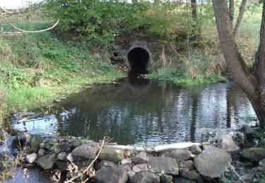
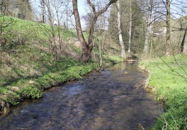
Trail On foot of 3.1 km to be discovered at Bavaria, Landkreis Aschaffenburg, Forst Hain im Spessart. This trail is proposed by SityTrail - itinéraires balisés pédestres.
Description
Trail created by Archäologisches Spessartprojekt.
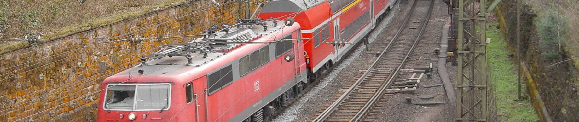
Symbol: Gelbe Dampflock mit EU-Sternenkreis auf blauem Grund
Website: https://www.spessartprojekt.de/?page_id=24292
Positioning
Comments
Trails nearby
![Trail On foot Neuhütten - Örtlicher Wanderweg Wiesthal 4 - Photo](https://media.geolcdn.com/t/375/260/a73328f4-f1d2-40d3-81b2-cec67c9182ba.jpeg&format=jpg&maxdim=2)
![On foot On foot](https://static1.geolcdn.com/sitytour/trail-icons/100.png)
On foot
![](/images/other/stat-length.png)
![](https://static1.geolcdn.com/siteimages/upload/files/16400158638029165_repeat_loop_refresh_sync_direction_icon.png)
![Trail On foot Wiesthal - Rote Schnepfe, Rundwanderweg Wiesthal - Photo](https://media.geolcdn.com/t/375/260/a73328f4-f1d2-40d3-81b2-cec67c9182ba.jpeg&format=jpg&maxdim=2)
![On foot On foot](https://static1.geolcdn.com/sitytour/trail-icons/100.png)
On foot
![](/images/other/stat-length.png)
![](https://static1.geolcdn.com/siteimages/upload/files/16400158638029165_repeat_loop_refresh_sync_direction_icon.png)
![Trail On foot Heinrichsthaler Forst - Örtlicher Wanderweg Wiesthal 2 - Photo](https://media.geolcdn.com/t/375/260/a73328f4-f1d2-40d3-81b2-cec67c9182ba.jpeg&format=jpg&maxdim=2)
![On foot On foot](https://static1.geolcdn.com/sitytour/trail-icons/100.png)
On foot
![](/images/other/stat-length.png)
![](https://static1.geolcdn.com/siteimages/upload/files/16400158638029165_repeat_loop_refresh_sync_direction_icon.png)
![Trail On foot Heinrichsthaler Forst - Nordic Walking 2 Habichsthal - Photo](https://media.geolcdn.com/t/375/260/e0a239ff-b4a4-416e-b8e6-2be493b78fa8.jpeg&format=jpg&maxdim=2)
![On foot On foot](https://static1.geolcdn.com/sitytour/trail-icons/100.png)
On foot
![](/images/other/stat-length.png)
![](https://static1.geolcdn.com/siteimages/upload/files/16400158638029165_repeat_loop_refresh_sync_direction_icon.png)
![Trail On foot Frammersbach - Blauer Laubbaum Rundwanderweg Habichsthal - Photo](https://media.geolcdn.com/t/375/260/e0a239ff-b4a4-416e-b8e6-2be493b78fa8.jpeg&format=jpg&maxdim=2)
![On foot On foot](https://static1.geolcdn.com/sitytour/trail-icons/100.png)
On foot
![](/images/other/stat-length.png)
![](https://static1.geolcdn.com/siteimages/upload/files/16400158638029165_repeat_loop_refresh_sync_direction_icon.png)
![Trail On foot Frammersbach - Roter Hase, Rundwanderweg Habichsthal - Photo](https://media.geolcdn.com/t/375/260/e0a239ff-b4a4-416e-b8e6-2be493b78fa8.jpeg&format=jpg&maxdim=2)
![On foot On foot](https://static1.geolcdn.com/sitytour/trail-icons/100.png)
On foot
![](/images/other/stat-length.png)
![](https://static1.geolcdn.com/siteimages/upload/files/16400158638029165_repeat_loop_refresh_sync_direction_icon.png)
![Trail On foot Neuhütten - Schwarzer Keiler, Rundwanderweg Neuhütten - Photo](https://media.geolcdn.com/t/375/260/f7bc1ef5-21ab-490f-b255-32a57b8dc44e.jpeg&format=jpg&maxdim=2)
![On foot On foot](https://static1.geolcdn.com/sitytour/trail-icons/100.png)
On foot
![](/images/other/stat-length.png)
![](https://static1.geolcdn.com/siteimages/upload/files/16400158638029165_repeat_loop_refresh_sync_direction_icon.png)
![Trail On foot Neuhütten - Schwarzer Fuchs, Rundwanderweg Neuhütten - Photo](https://media.geolcdn.com/t/375/260/f7bc1ef5-21ab-490f-b255-32a57b8dc44e.jpeg&format=jpg&maxdim=2)
![On foot On foot](https://static1.geolcdn.com/sitytour/trail-icons/100.png)
On foot
![](/images/other/stat-length.png)
![](https://static1.geolcdn.com/siteimages/upload/files/16400158638029165_repeat_loop_refresh_sync_direction_icon.png)
![Trail On foot Heigenbrücken - Schwarzer Keiler, Rundwanderweg Heigenbrücken - Kalter Grund - Photo](https://media.geolcdn.com/t/375/260/14877042-c02b-4e79-be7e-aa0b37b11b5e.jpeg&format=jpg&maxdim=2)
![On foot On foot](https://static1.geolcdn.com/sitytour/trail-icons/100.png)
On foot
![](/images/other/stat-length.png)
![](https://static1.geolcdn.com/siteimages/upload/files/16400158638029165_repeat_loop_refresh_sync_direction_icon.png)