![](/images/other/stat-length.png)
![Trail On foot Gomadingen - DonauFelsenLäufe: Donaufelsengarten - Photo](https://media.geolcdn.com/t/1900/400/ext.pjpeg?maxdim=2&url=https%3A%2F%2Fmedia.geolcdn.com%2Ff%2F22dd9b2b-1ca2-4a2e-bdae-3364be5f5d4c.jpeg)
DonauFelsenLäufe: Donaufelsengarten
SityTrail - itinéraires balisés pédestres
Tous les sentiers balisés d’Europe PRO
![Length](/images/other/stat-length.png)
Length
4.7 km
![Max alt](https://static1.geolcdn.com/siteimages/upload/files/1508320355ic_sort_altitude_max_24dp.png)
Max alt
722 m
![Uphill gradient](https://static1.geolcdn.com/siteimages/upload/files/1508320355ic_sort_den_pos_24dp.png)
Uphill gradient
221 m
![Km-Effort](/images/other/stat-length.png)
Km-Effort
7.5 km
![Min alt](https://static1.geolcdn.com/siteimages/upload/files/1508320355ic_sort_altitude_min_24dp.png)
Min alt
599 m
![Downhill gradient](https://static1.geolcdn.com/siteimages/upload/files/1508320355ic_sort_den_neg_24dp.png)
Downhill gradient
167 m
![Boucle](https://static1.geolcdn.com/siteimages/upload/files/16400158638029165_repeat_loop_refresh_sync_direction_icon.png)
Boucle
No
Signpost
Creation date :
2022-02-11 19:17:39.733
Updated on :
2022-02-11 19:17:39.733
![On foot](https://static1.geolcdn.com/sitytour/trail-icons/100.png)
1h42
Difficulty : Easy
![Scan this QR Code to open this trail in the SityTrail application](https://capi.geolives.com/qq0zvz2zws4bq2lad0pu/sitytour/trails/3100477/qr.png?size=200)
FREE GPS app for hiking
About
Trail On foot of 4.7 km to be discovered at Baden-Württemberg, Landkreis Reutlingen, Gomadingen. This trail is proposed by SityTrail - itinéraires balisés pédestres.
Description
Lebendig. Spannend. Einladend. Willkommen in der Stadt Sigmaringen! Wir sind Ihr Ansprechpartner vor Ort.
Website: http://www.sigmaringen.de/de/Freizeit-Tourismus/Aktiv-Natur/Wandern/
Positioning
Country:
Germany
Region :
Baden-Württemberg
Department/Province :
Landkreis Reutlingen
Municipality :
Gomadingen
Location:
Unknown
Start:(Dec)
Start:(UTM)
508194 ; 5326446 (32U) N.
Comments
Trails nearby
![Trail On foot Gomadingen - Donau Felsen Läufe: Wilde Täler - Fürstliche Höhen - Photo](https://media.geolcdn.com/t/375/260/ext.jpg?maxdim=2&url=https%3A%2F%2Fmedia.geolcdn.com%2Ff%2Fdd777c6f-8dfd-417c-a90f-7bba84ff9ddf.jpeg)
![On foot On foot](https://static1.geolcdn.com/sitytour/trail-icons/100.png)
Donau Felsen Läufe: Wilde Täler - Fürstliche Höhen
On foot
Easy
Gomadingen,
Baden-Württemberg,
Landkreis Reutlingen,
Germany
![](/images/other/stat-length.png)
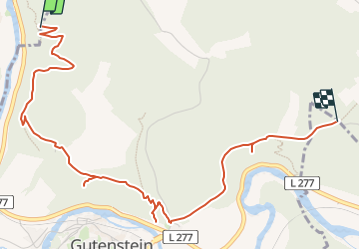
12.6 km | 17.1 km-effort
3h 53min
![](https://static1.geolcdn.com/siteimages/upload/files/16400158638029165_repeat_loop_refresh_sync_direction_icon.png)
Yes