![](/images/other/stat-length.png)
![Trail On foot Horn-Bad Meinberg - Oh! 8 - KinderErlebniswelt Natur - Photo](https://media.geolcdn.com/t/1900/400/9fe25be8-744f-465d-9bd2-3708217eca3b.jpeg&format=pjpeg&maxdim=2)
Oh! 8 - KinderErlebniswelt Natur
SityTrail - itinéraires balisés pédestres
Tous les sentiers balisés d’Europe GUIDE+
![Length](/images/other/stat-length.png)
Length
4.6 km
![Max alt](https://static1.geolcdn.com/siteimages/upload/files/1508320355ic_sort_altitude_max_24dp.png)
Max alt
461 m
![Uphill gradient](https://static1.geolcdn.com/siteimages/upload/files/1508320355ic_sort_den_pos_24dp.png)
Uphill gradient
232 m
![Km-Effort](/images/other/stat-length.png)
Km-Effort
7 km
![Min alt](https://static1.geolcdn.com/siteimages/upload/files/1508320355ic_sort_altitude_min_24dp.png)
Min alt
248 m
![Downhill gradient](https://static1.geolcdn.com/siteimages/upload/files/1508320355ic_sort_den_neg_24dp.png)
Downhill gradient
22 m
![Boucle](https://static1.geolcdn.com/siteimages/upload/files/16400158638029165_repeat_loop_refresh_sync_direction_icon.png)
Boucle
No
Signpost
Creation date :
2022-02-11 19:08:26.464
Updated on :
2022-02-11 19:08:26.464
![On foot](https://static1.geolcdn.com/sitytour/trail-icons/100.png)
1h35
Difficulty : Easy
![Scan this QR Code to open this trail in the SityTrail application](https://capi.geolives.com/qq0zvz2zws4bq2lad0pu/sitytour/trails/3100312/qr.png?size=200)
FREE GPS app for hiking
About
Trail On foot of 4.6 km to be discovered at North Rhine-Westphalia, Kreis Lippe, Horn-Bad Meinberg. This trail is proposed by SityTrail - itinéraires balisés pédestres.
Description
Trail created by Naturpark Teutoburger Wald Eggegebirge.
Positioning
Country:
Germany
Region :
North Rhine-Westphalia
Department/Province :
Kreis Lippe
Municipality :
Horn-Bad Meinberg
Location:
Unknown
Start:(Dec)
Start:(UTM)
496855 ; 5744600 (32U) N.
Comments
Trails nearby
![Trail On foot Horn-Bad Meinberg - Pilgerweg](https://media.geolcdn.com/t/375/260/82208e22-56ad-4715-9507-28234728434e.jpeg&format=jpg&maxdim=2)
![On foot On foot](https://static1.geolcdn.com/sitytour/trail-icons/100.png)
Pilgerweg "Besinn DICH… SEHEN, HÖREN, FÜHLEN - Besinnungsweg Kempen-Feldrom-V...
On foot
Easy
Horn-Bad Meinberg,
North Rhine-Westphalia,
Kreis Lippe,
Germany
![](/images/other/stat-length.png)
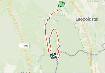
3.1 km | 4.3 km-effort
58min
![](https://static1.geolcdn.com/siteimages/upload/files/16400158638029165_repeat_loop_refresh_sync_direction_icon.png)
Yes
![Trail On foot Horn-Bad Meinberg - Besinnungsweg (Kempen-Feldrom-Veldrom) - Photo](https://media.geolcdn.com/t/375/260/82208e22-56ad-4715-9507-28234728434e.jpeg&format=jpg&maxdim=2)
![On foot On foot](https://static1.geolcdn.com/sitytour/trail-icons/100.png)
Besinnungsweg (Kempen-Feldrom-Veldrom)
On foot
Easy
Horn-Bad Meinberg,
North Rhine-Westphalia,
Kreis Lippe,
Germany
![](/images/other/stat-length.png)
4.5 km | 5.9 km-effort
1h 20min
![](https://static1.geolcdn.com/siteimages/upload/files/16400158638029165_repeat_loop_refresh_sync_direction_icon.png)
No
![Trail On foot Horn-Bad Meinberg - Rundwanderweg A4 [Feldrom] - Photo](https://media.geolcdn.com/t/375/260/c3e2fda2-4a4b-4515-b251-ad31aeb36002.jpeg&format=jpg&maxdim=2)
![On foot On foot](https://static1.geolcdn.com/sitytour/trail-icons/100.png)
Rundwanderweg A4 [Feldrom]
On foot
Easy
Horn-Bad Meinberg,
North Rhine-Westphalia,
Kreis Lippe,
Germany
![](/images/other/stat-length.png)
3.3 km | 4.7 km-effort
1h 4min
![](https://static1.geolcdn.com/siteimages/upload/files/16400158638029165_repeat_loop_refresh_sync_direction_icon.png)
Yes
![Trail On foot Horn-Bad Meinberg - Rundwanderweg A2 [Feldrom] - Photo](https://media.geolcdn.com/t/375/260/82208e22-56ad-4715-9507-28234728434e.jpeg&format=jpg&maxdim=2)
![On foot On foot](https://static1.geolcdn.com/sitytour/trail-icons/100.png)
Rundwanderweg A2 [Feldrom]
On foot
Easy
Horn-Bad Meinberg,
North Rhine-Westphalia,
Kreis Lippe,
Germany
![](/images/other/stat-length.png)
3.4 km | 5.1 km-effort
1h 8min
![](https://static1.geolcdn.com/siteimages/upload/files/16400158638029165_repeat_loop_refresh_sync_direction_icon.png)
Yes
![Trail On foot Steinheim - Rundwanderweg A1 [Grevenhagen] - Photo](https://media.geolcdn.com/t/375/260/202ac17e-dbff-44d1-b3d9-93eb341f466c.jpeg&format=jpg&maxdim=2)
![On foot On foot](https://static1.geolcdn.com/sitytour/trail-icons/100.png)
Rundwanderweg A1 [Grevenhagen]
On foot
Easy
Steinheim,
North Rhine-Westphalia,
Kreis Höxter,
Germany
![](/images/other/stat-length.png)
8.3 km | 11 km-effort
2h 30min
![](https://static1.geolcdn.com/siteimages/upload/files/16400158638029165_repeat_loop_refresh_sync_direction_icon.png)
Yes
![Trail On foot Horn-Bad Meinberg - Zugangsweg Hermannshöhen - Horn-Bad Meinberg - Photo](https://media.geolcdn.com/t/375/260/481dc017-712c-4a92-87e6-77c38ebad9f4.jpeg&format=jpg&maxdim=2)
![On foot On foot](https://static1.geolcdn.com/sitytour/trail-icons/100.png)
Zugangsweg Hermannshöhen - Horn-Bad Meinberg
On foot
Easy
Horn-Bad Meinberg,
North Rhine-Westphalia,
Kreis Lippe,
Germany
![](/images/other/stat-length.png)
5.5 km | 6.2 km-effort
1h 25min
![](https://static1.geolcdn.com/siteimages/upload/files/16400158638029165_repeat_loop_refresh_sync_direction_icon.png)
No
![Trail On foot Horn-Bad Meinberg - Rundwanderweg A1 [Holzhausen-Externsteine] - Photo](https://media.geolcdn.com/t/375/260/917c6440-8043-45d4-9c08-101f3367a522.jpeg&format=jpg&maxdim=2)
![On foot On foot](https://static1.geolcdn.com/sitytour/trail-icons/100.png)
Rundwanderweg A1 [Holzhausen-Externsteine]
On foot
Easy
Horn-Bad Meinberg,
North Rhine-Westphalia,
Kreis Lippe,
Germany
![](/images/other/stat-length.png)
3.4 km | 4.2 km-effort
56min
![](https://static1.geolcdn.com/siteimages/upload/files/16400158638029165_repeat_loop_refresh_sync_direction_icon.png)
Yes
![Trail On foot Horn-Bad Meinberg - Terrainkurweg 5 [Bad Meinberg] - Photo](https://media.geolcdn.com/t/375/260/c6c364b8-a98c-4894-be50-01092c15d2a2.jpeg&format=jpg&maxdim=2)
![On foot On foot](https://static1.geolcdn.com/sitytour/trail-icons/100.png)
Terrainkurweg 5 [Bad Meinberg]
On foot
Easy
Horn-Bad Meinberg,
North Rhine-Westphalia,
Kreis Lippe,
Germany
![](/images/other/stat-length.png)
3.3 km | 3.9 km-effort
53min
![](https://static1.geolcdn.com/siteimages/upload/files/16400158638029165_repeat_loop_refresh_sync_direction_icon.png)
Yes
![Trail On foot Horn-Bad Meinberg - Terrainkurweg 4 [Bad Meinberg] - Photo](https://media.geolcdn.com/t/375/260/17855ced-c021-469c-b31b-b1f4ceaf95e0.jpeg&format=jpg&maxdim=2)
![On foot On foot](https://static1.geolcdn.com/sitytour/trail-icons/100.png)
Terrainkurweg 4 [Bad Meinberg]
On foot
Easy
Horn-Bad Meinberg,
North Rhine-Westphalia,
Kreis Lippe,
Germany
![](/images/other/stat-length.png)
5.2 km | 6.3 km-effort
1h 26min
![](https://static1.geolcdn.com/siteimages/upload/files/16400158638029165_repeat_loop_refresh_sync_direction_icon.png)
Yes