![](/images/other/stat-length.png)
![Trail On foot Heidenrod - Wispertaunussteig - Photo](https://media.geolcdn.com/t/1900/400/902c35bb-831b-4361-9c05-b78bf7cf26af.jpeg&format=pjpeg&maxdim=2)
Wispertaunussteig
SityTrail - itinéraires balisés pédestres
Tous les sentiers balisés d’Europe GUIDE+
![Length](/images/other/stat-length.png)
Length
26 km
![Max alt](https://static1.geolcdn.com/siteimages/upload/files/1508320355ic_sort_altitude_max_24dp.png)
Max alt
463 m
![Uphill gradient](https://static1.geolcdn.com/siteimages/upload/files/1508320355ic_sort_den_pos_24dp.png)
Uphill gradient
977 m
![Km-Effort](/images/other/stat-length.png)
Km-Effort
39 km
![Min alt](https://static1.geolcdn.com/siteimages/upload/files/1508320355ic_sort_altitude_min_24dp.png)
Min alt
183 m
![Downhill gradient](https://static1.geolcdn.com/siteimages/upload/files/1508320355ic_sort_den_neg_24dp.png)
Downhill gradient
894 m
![Boucle](https://static1.geolcdn.com/siteimages/upload/files/16400158638029165_repeat_loop_refresh_sync_direction_icon.png)
Boucle
No
Signpost
Creation date :
2022-02-11 19:07:15.786
Updated on :
2022-02-11 19:07:15.786
![On foot](https://static1.geolcdn.com/sitytour/trail-icons/100.png)
8h54
Difficulty : Difficult
![Scan this QR Code to open this trail in the SityTrail application](https://capi.geolives.com/qq0zvz2zws4bq2lad0pu/sitytour/trails/3100283/qr.png?size=200)
FREE GPS app for hiking
About
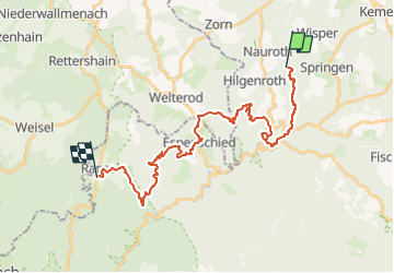
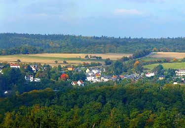
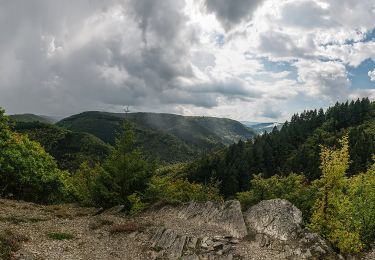
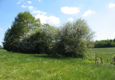
Trail On foot of 26 km to be discovered at Hesse, Rheingau-Taunus-Kreis, Heidenrod. This trail is proposed by SityTrail - itinéraires balisés pédestres.
Description
Trail created by Gemeinden Heidenrod, Lorch am Rhein, Bad Schwalbach, Schlangenbad und Rüdesheim.
Positioning
Country:
Germany
Region :
Hesse
Department/Province :
Rheingau-Taunus-Kreis
Municipality :
Heidenrod
Location:
Unknown
Start:(Dec)
Start:(UTM)
425629 ; 5554982 (32U) N.
Comments
Trails nearby
![Trail On foot Heidenrod - Dickschieder Wildwechsel - Photo](https://media.geolcdn.com/t/375/260/1317a9d5-9d72-4b1c-b97f-77cebb4d5d55.jpeg&format=jpg&maxdim=2)
![On foot On foot](https://static1.geolcdn.com/sitytour/trail-icons/100.png)
Dickschieder Wildwechsel
On foot
Easy
Heidenrod,
Hesse,
Rheingau-Taunus-Kreis,
Germany
![](/images/other/stat-length.png)
9.9 km | 13.8 km-effort
3h 7min
![](https://static1.geolcdn.com/siteimages/upload/files/16400158638029165_repeat_loop_refresh_sync_direction_icon.png)
No
![Trail On foot Heidenrod - Naurother Grubengold - Photo](https://media.geolcdn.com/t/375/260/ec400498-09c2-4027-a72a-02659a5d515d.jpeg&format=jpg&maxdim=2)
![On foot On foot](https://static1.geolcdn.com/sitytour/trail-icons/100.png)
Naurother Grubengold
On foot
Easy
Heidenrod,
Hesse,
Rheingau-Taunus-Kreis,
Germany
![](/images/other/stat-length.png)
13.7 km | 18.8 km-effort
4h 16min
![](https://static1.geolcdn.com/siteimages/upload/files/16400158638029165_repeat_loop_refresh_sync_direction_icon.png)
Yes
![Trail On foot Lorch - Wispertaler Krönchen - Photo](https://media.geolcdn.com/t/375/260/a9438b40-625e-4c49-8e8d-e41177db7513.jpeg&format=jpg&maxdim=2)
![On foot On foot](https://static1.geolcdn.com/sitytour/trail-icons/100.png)
Wispertaler Krönchen
On foot
Easy
Lorch,
Hesse,
Rheingau-Taunus-Kreis,
Germany
![](/images/other/stat-length.png)
5.1 km | 6.6 km-effort
1h 30min
![](https://static1.geolcdn.com/siteimages/upload/files/16400158638029165_repeat_loop_refresh_sync_direction_icon.png)
Yes
![Trail On foot Bad Schwalbach - Schwälbchen's Flug - Photo](https://media.geolcdn.com/t/375/260/af2a96e4-3837-4938-99ba-d57b1d943191.jpeg&format=jpg&maxdim=2)
![On foot On foot](https://static1.geolcdn.com/sitytour/trail-icons/100.png)
Schwälbchen's Flug
On foot
Easy
Bad Schwalbach,
Hesse,
Rheingau-Taunus-Kreis,
Germany
![](/images/other/stat-length.png)
10.7 km | 14.4 km-effort
3h 16min
![](https://static1.geolcdn.com/siteimages/upload/files/16400158638029165_repeat_loop_refresh_sync_direction_icon.png)
Yes
![Trail On foot Bad Schwalbach - Fischbach - Langenseifen - Photo](https://media.geolcdn.com/t/375/260/af2a96e4-3837-4938-99ba-d57b1d943191.jpeg&format=jpg&maxdim=2)
![On foot On foot](https://static1.geolcdn.com/sitytour/trail-icons/100.png)
Fischbach - Langenseifen
On foot
Easy
Bad Schwalbach,
Hesse,
Rheingau-Taunus-Kreis,
Germany
![](/images/other/stat-length.png)
3.2 km | 4 km-effort
54min
![](https://static1.geolcdn.com/siteimages/upload/files/16400158638029165_repeat_loop_refresh_sync_direction_icon.png)
No
![Trail On foot Lorch - Wispertalsteig - Photo](https://media.geolcdn.com/t/375/260/07ffdc03-fb4d-403b-9008-68a213119c99.jpeg&format=jpg&maxdim=2)
![On foot On foot](https://static1.geolcdn.com/sitytour/trail-icons/100.png)
Wispertalsteig
On foot
Medium
Lorch,
Hesse,
Rheingau-Taunus-Kreis,
Germany
![](/images/other/stat-length.png)
15.1 km | 21 km-effort
4h 52min
![](https://static1.geolcdn.com/siteimages/upload/files/16400158638029165_repeat_loop_refresh_sync_direction_icon.png)
Yes
![Trail On foot Heidenrod - Im Wisper Outback - Photo](https://media.geolcdn.com/t/375/260/7c12f562-492a-4095-b8dd-c8325b71e630.jpeg&format=jpg&maxdim=2)
![On foot On foot](https://static1.geolcdn.com/sitytour/trail-icons/100.png)
Im Wisper Outback
On foot
Easy
Heidenrod,
Hesse,
Rheingau-Taunus-Kreis,
Germany
![](/images/other/stat-length.png)
13.2 km | 18.2 km-effort
4h 8min
![](https://static1.geolcdn.com/siteimages/upload/files/16400158638029165_repeat_loop_refresh_sync_direction_icon.png)
Yes
![Trail On foot Heidenrod - Zorner Runde - Photo](https://media.geolcdn.com/t/375/260/ae44ed19-475c-4a82-a6de-a341e796aa70.jpeg&format=jpg&maxdim=2)
![On foot On foot](https://static1.geolcdn.com/sitytour/trail-icons/100.png)
Zorner Runde
On foot
Easy
Heidenrod,
Hesse,
Rheingau-Taunus-Kreis,
Germany
![](/images/other/stat-length.png)
4.9 km | 6.1 km-effort
1h 23min
![](https://static1.geolcdn.com/siteimages/upload/files/16400158638029165_repeat_loop_refresh_sync_direction_icon.png)
Yes
![Trail On foot Heidenrod - Wisper Geflüster - Photo](https://media.geolcdn.com/t/375/260/ext.jpg?maxdim=2&url=https%3A%2F%2Fstatic1.geolcdn.com%2Fsiteimages%2Fupload%2Ffiles%2F1545311037marcheuse_200dpi.jpg)
![On foot On foot](https://static1.geolcdn.com/sitytour/trail-icons/100.png)
Wisper Geflüster
On foot
Easy
Heidenrod,
Hesse,
Rheingau-Taunus-Kreis,
Germany
![](/images/other/stat-length.png)
8.4 km | 11.2 km-effort
2h 32min
![](https://static1.geolcdn.com/siteimages/upload/files/16400158638029165_repeat_loop_refresh_sync_direction_icon.png)
Yes