![](/images/other/stat-length.png)
![Trail On foot Lübbecke - Nikolausweg - Photo](https://media.geolcdn.com/t/1900/400/ext.pjpeg?maxdim=2&url=https%3A%2F%2Fmedia.geolcdn.com%2Ff%2F60e6984e-4ab4-410b-abec-52f37900380b.jpeg)
Nikolausweg
SityTrail - itinéraires balisés pédestres
Tous les sentiers balisés d’Europe PRO
![Length](/images/other/stat-length.png)
Length
9.9 km
![Max alt](https://static1.geolcdn.com/siteimages/upload/files/1508320355ic_sort_altitude_max_24dp.png)
Max alt
271 m
![Uphill gradient](https://static1.geolcdn.com/siteimages/upload/files/1508320355ic_sort_den_pos_24dp.png)
Uphill gradient
273 m
![Km-Effort](/images/other/stat-length.png)
Km-Effort
12.9 km
![Min alt](https://static1.geolcdn.com/siteimages/upload/files/1508320355ic_sort_altitude_min_24dp.png)
Min alt
51 m
![Downhill gradient](https://static1.geolcdn.com/siteimages/upload/files/1508320355ic_sort_den_neg_24dp.png)
Downhill gradient
61 m
![Boucle](https://static1.geolcdn.com/siteimages/upload/files/16400158638029165_repeat_loop_refresh_sync_direction_icon.png)
Boucle
No
Signpost
Creation date :
2022-02-11 19:04:37.654
Updated on :
2022-02-11 19:04:37.654
![On foot](https://static1.geolcdn.com/sitytour/trail-icons/100.png)
2h55
Difficulty : Easy
![Scan this QR Code to open this trail in the SityTrail application](https://capi.geolives.com/qq0zvz2zws4bq2lad0pu/sitytour/trails/3100220/qr.png?size=200)
FREE GPS app for hiking
About
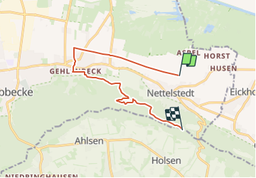
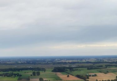
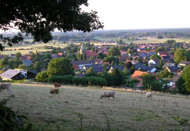
Trail On foot of 9.9 km to be discovered at North Rhine-Westphalia, Kreis Minden-Lübbecke, Lübbecke. This trail is proposed by SityTrail - itinéraires balisés pédestres.
Description
Trail created by Ev.-Luth. Kirchengemeinde Gehlenbeck.
Symbol: Gelbe Bischofsmütze auf rotem Grund
Website: https://nikolausweg.de/
Positioning
Country:
Germany
Region :
North Rhine-Westphalia
Department/Province :
Kreis Minden-Lübbecke
Municipality :
Lübbecke
Location:
Unknown
Start:(Dec)
Start:(UTM)
479571 ; 5795273 (32U) N.
Comments
Trails nearby
![Trail On foot Lübbecke - Nikolausweg - Alternativroute](https://media.geolcdn.com/t/375/260/ext.jpg?maxdim=2&url=https%3A%2F%2Fmedia.geolcdn.com%2Ff%2F6667e3c2-796d-4c63-b4e8-c438d993be8c.jpeg)
![On foot On foot](https://static1.geolcdn.com/sitytour/trail-icons/100.png)
Nikolausweg - Alternativroute "Großes Torfmoor"
On foot
Easy
Lübbecke,
North Rhine-Westphalia,
Kreis Minden-Lübbecke,
Germany
![](/images/other/stat-length.png)
5.6 km | 6.1 km-effort
1h 22min
![](https://static1.geolcdn.com/siteimages/upload/files/16400158638029165_repeat_loop_refresh_sync_direction_icon.png)
No
![Trail On foot Hille - A2 Hille-Torfmoor - Photo](https://media.geolcdn.com/t/375/260/ext.jpg?maxdim=2&url=https%3A%2F%2Fmedia.geolcdn.com%2Ff%2Fd97d4654-4399-467b-9f8d-e2462366fd1d.jpeg)
![On foot On foot](https://static1.geolcdn.com/sitytour/trail-icons/100.png)
A2 Hille-Torfmoor
On foot
Easy
Hille,
North Rhine-Westphalia,
Kreis Minden-Lübbecke,
Germany
![](/images/other/stat-length.png)
9.1 km | 9.7 km-effort
2h 11min
![](https://static1.geolcdn.com/siteimages/upload/files/16400158638029165_repeat_loop_refresh_sync_direction_icon.png)
Yes
![Trail On foot Hüllhorst - A1 Hüllhorst-Schnathorst - Photo](https://media.geolcdn.com/t/375/260/ext.jpg?maxdim=2&url=https%3A%2F%2Fmedia.geolcdn.com%2Ff%2F17e438d4-7b0a-4ff0-89e5-c7c2a4d87065.jpeg)
![On foot On foot](https://static1.geolcdn.com/sitytour/trail-icons/100.png)
A1 Hüllhorst-Schnathorst
On foot
Easy
Hüllhorst,
North Rhine-Westphalia,
Kreis Minden-Lübbecke,
Germany
![](/images/other/stat-length.png)
4.4 km | 5.1 km-effort
1h 9min
![](https://static1.geolcdn.com/siteimages/upload/files/16400158638029165_repeat_loop_refresh_sync_direction_icon.png)
Yes
![Trail On foot Hüllhorst - A3 Hüllhorst-Schnathorst - Photo](https://media.geolcdn.com/t/375/260/ext.jpg?maxdim=2&url=https%3A%2F%2Fmedia.geolcdn.com%2Ff%2F17e438d4-7b0a-4ff0-89e5-c7c2a4d87065.jpeg)
![On foot On foot](https://static1.geolcdn.com/sitytour/trail-icons/100.png)
A3 Hüllhorst-Schnathorst
On foot
Easy
Hüllhorst,
North Rhine-Westphalia,
Kreis Minden-Lübbecke,
Germany
![](/images/other/stat-length.png)
5.7 km | 7.2 km-effort
1h 38min
![](https://static1.geolcdn.com/siteimages/upload/files/16400158638029165_repeat_loop_refresh_sync_direction_icon.png)
Yes
![Trail On foot Hüllhorst - A2 Hüllhorst-Schnathorst - Photo](https://media.geolcdn.com/t/375/260/ext.jpg?maxdim=2&url=https%3A%2F%2Fmedia.geolcdn.com%2Ff%2F17e438d4-7b0a-4ff0-89e5-c7c2a4d87065.jpeg)
![On foot On foot](https://static1.geolcdn.com/sitytour/trail-icons/100.png)
A2 Hüllhorst-Schnathorst
On foot
Easy
Hüllhorst,
North Rhine-Westphalia,
Kreis Minden-Lübbecke,
Germany
![](/images/other/stat-length.png)
6.5 km | 8.4 km-effort
1h 54min
![](https://static1.geolcdn.com/siteimages/upload/files/16400158638029165_repeat_loop_refresh_sync_direction_icon.png)
Yes
![Trail On foot Lübbecke - A3 Lübbecke-Eilhausen - Photo](https://media.geolcdn.com/t/375/260/ext.jpg?maxdim=2&url=https%3A%2F%2Fmedia.geolcdn.com%2Ff%2F60e6984e-4ab4-410b-abec-52f37900380b.jpeg)
![On foot On foot](https://static1.geolcdn.com/sitytour/trail-icons/100.png)
A3 Lübbecke-Eilhausen
On foot
Easy
Lübbecke,
North Rhine-Westphalia,
Kreis Minden-Lübbecke,
Germany
![](/images/other/stat-length.png)
4.5 km | 6.3 km-effort
1h 25min
![](https://static1.geolcdn.com/siteimages/upload/files/16400158638029165_repeat_loop_refresh_sync_direction_icon.png)
Yes
![Trail On foot Lübbecke - A2 Lübbecke-Gehlenbeck - Photo](https://media.geolcdn.com/t/375/260/ext.jpg?maxdim=2&url=https%3A%2F%2Fmedia.geolcdn.com%2Ff%2F184a058e-0f15-4748-be6d-36f4c48bd30d.jpeg)
![On foot On foot](https://static1.geolcdn.com/sitytour/trail-icons/100.png)
A2 Lübbecke-Gehlenbeck
On foot
Easy
Lübbecke,
North Rhine-Westphalia,
Kreis Minden-Lübbecke,
Germany
![](/images/other/stat-length.png)
4.1 km | 6.3 km-effort
1h 26min
![](https://static1.geolcdn.com/siteimages/upload/files/16400158638029165_repeat_loop_refresh_sync_direction_icon.png)
Yes
![Trail On foot Lübbecke - A3 Hille-Torfmoor - Photo](https://media.geolcdn.com/t/375/260/ext.jpg?maxdim=2&url=https%3A%2F%2Fmedia.geolcdn.com%2Ff%2F3624c570-4b94-4065-ab14-83b7ce71dca2.jpeg)
![On foot On foot](https://static1.geolcdn.com/sitytour/trail-icons/100.png)
A3 Hille-Torfmoor
On foot
Easy
Lübbecke,
North Rhine-Westphalia,
Kreis Minden-Lübbecke,
Germany
![](/images/other/stat-length.png)
7.5 km | 7.9 km-effort
1h 47min
![](https://static1.geolcdn.com/siteimages/upload/files/16400158638029165_repeat_loop_refresh_sync_direction_icon.png)
Yes
![Trail On foot Hille - A1 Hille-Torfmoor - Photo](https://media.geolcdn.com/t/375/260/ext.jpg?maxdim=2&url=https%3A%2F%2Fstatic1.geolcdn.com%2Fsiteimages%2Fupload%2Ffiles%2F1545311037marcheuse_200dpi.jpg)
![On foot On foot](https://static1.geolcdn.com/sitytour/trail-icons/100.png)
A1 Hille-Torfmoor
On foot
Easy
Hille,
North Rhine-Westphalia,
Kreis Minden-Lübbecke,
Germany
![](/images/other/stat-length.png)
7.1 km | 7.7 km-effort
1h 45min
![](https://static1.geolcdn.com/siteimages/upload/files/16400158638029165_repeat_loop_refresh_sync_direction_icon.png)
No