![](/images/other/stat-length.png)
![Trail On foot Unknown - Rundwege Hagen 3TürmeWEG - Photo](https://media.geolcdn.com/t/1900/400/836594e2-4f78-4366-a0e0-33994641110a.jpeg&format=pjpeg&maxdim=2)
Rundwege Hagen 3TürmeWEG
SityTrail - itinéraires balisés pédestres
Tous les sentiers balisés d’Europe GUIDE+
![Length](/images/other/stat-length.png)
Length
11 km
![Max alt](https://static1.geolcdn.com/siteimages/upload/files/1508320355ic_sort_altitude_max_24dp.png)
Max alt
379 m
![Uphill gradient](https://static1.geolcdn.com/siteimages/upload/files/1508320355ic_sort_den_pos_24dp.png)
Uphill gradient
304 m
![Km-Effort](/images/other/stat-length.png)
Km-Effort
15 km
![Min alt](https://static1.geolcdn.com/siteimages/upload/files/1508320355ic_sort_altitude_min_24dp.png)
Min alt
165 m
![Downhill gradient](https://static1.geolcdn.com/siteimages/upload/files/1508320355ic_sort_den_neg_24dp.png)
Downhill gradient
300 m
![Boucle](https://static1.geolcdn.com/siteimages/upload/files/16400158638029165_repeat_loop_refresh_sync_direction_icon.png)
Boucle
Yes
Signpost
Creation date :
2022-02-11 18:51:51.663
Updated on :
2022-02-11 18:51:51.663
![On foot](https://static1.geolcdn.com/sitytour/trail-icons/100.png)
3h25
Difficulty : Easy
![Scan this QR Code to open this trail in the SityTrail application](https://capi.geolives.com/qq0zvz2zws4bq2lad0pu/sitytour/trails/3099954/qr.png?size=200)
FREE GPS app for hiking
About
Trail On foot of 11 km to be discovered at North Rhine-Westphalia, Hagen, Unknown. This trail is proposed by SityTrail - itinéraires balisés pédestres.
Description
Trail created by Sauerländischer Gebirgsverein.
Positioning
Country:
Germany
Region :
North Rhine-Westphalia
Department/Province :
Hagen
Municipality :
Unknown
Location:
Hagen-Mitte
Start:(Dec)
Start:(UTM)
393209 ; 5690099 (32U) N.
Comments
Trails nearby
![Trail On foot Herdecke - [H2] Ruhrtal zum Hickenstein - Photo](https://media.geolcdn.com/t/375/260/47dfa9a4-572d-4f34-b111-ae10e112c377.jpeg&format=jpg&maxdim=2)
![On foot On foot](https://static1.geolcdn.com/sitytour/trail-icons/100.png)
[H2] Ruhrtal zum Hickenstein
On foot
Easy
Herdecke,
North Rhine-Westphalia,
Ennepe-Ruhr-Kreis,
Germany
![](/images/other/stat-length.png)
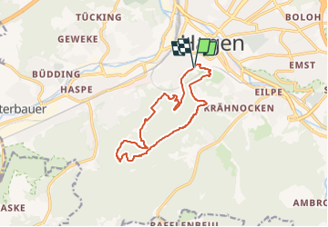
8.4 km | 12.2 km-effort
2h 45min
![](https://static1.geolcdn.com/siteimages/upload/files/16400158638029165_repeat_loop_refresh_sync_direction_icon.png)
Yes
![Trail On foot Herdecke - [H1] Viadukt und Nacken - Photo](https://media.geolcdn.com/t/375/260/0816fcff-a194-4a3a-b211-f59c276124fc.jpeg&format=jpg&maxdim=2)
![On foot On foot](https://static1.geolcdn.com/sitytour/trail-icons/100.png)
[H1] Viadukt und Nacken
On foot
Easy
Herdecke,
North Rhine-Westphalia,
Ennepe-Ruhr-Kreis,
Germany
![](/images/other/stat-length.png)
5.3 km | 7.6 km-effort
1h 43min
![](https://static1.geolcdn.com/siteimages/upload/files/16400158638029165_repeat_loop_refresh_sync_direction_icon.png)
Yes
![Trail On foot Unknown - Hohensteinweg - Photo](https://media.geolcdn.com/t/375/260/bb733b20-9134-4075-8548-696dce4a3fea.jpeg&format=jpg&maxdim=2)
![On foot On foot](https://static1.geolcdn.com/sitytour/trail-icons/100.png)
Hohensteinweg
On foot
Easy
Unknown,
North Rhine-Westphalia,
Hagen,
Germany
![](/images/other/stat-length.png)
11.5 km | 16.2 km-effort
3h 40min
![](https://static1.geolcdn.com/siteimages/upload/files/16400158638029165_repeat_loop_refresh_sync_direction_icon.png)
No
![Trail On foot Ennepetal - Voerde Rundweg A7 - Photo](https://media.geolcdn.com/t/375/260/06f812dd-828f-4932-abc8-6edb7058f4bf.jpeg&format=jpg&maxdim=2)
![On foot On foot](https://static1.geolcdn.com/sitytour/trail-icons/100.png)
Voerde Rundweg A7
On foot
Easy
Ennepetal,
North Rhine-Westphalia,
Ennepe-Ruhr-Kreis,
Germany
![](/images/other/stat-length.png)
5.2 km | 6.8 km-effort
1h 33min
![](https://static1.geolcdn.com/siteimages/upload/files/16400158638029165_repeat_loop_refresh_sync_direction_icon.png)
No
![Trail On foot Unknown - [-] Höhenweg Wehringhausen - Herdecke - Photo](https://media.geolcdn.com/t/375/260/4387e361-0797-400d-87e7-45695bb9bdc7.jpeg&format=jpg&maxdim=2)
![On foot On foot](https://static1.geolcdn.com/sitytour/trail-icons/100.png)
[-] Höhenweg Wehringhausen - Herdecke
On foot
Easy
Unknown,
North Rhine-Westphalia,
Hagen,
Germany
![](/images/other/stat-length.png)
7.3 km | 10.4 km-effort
2h 22min
![](https://static1.geolcdn.com/siteimages/upload/files/16400158638029165_repeat_loop_refresh_sync_direction_icon.png)
No
![Trail On foot Unknown - Hanseweg - Photo](https://media.geolcdn.com/t/375/260/2f656931-d097-4903-a5fe-f66df494e745.jpeg&format=jpg&maxdim=2)
![On foot On foot](https://static1.geolcdn.com/sitytour/trail-icons/100.png)
Hanseweg
On foot
Easy
Unknown,
North Rhine-Westphalia,
Hagen,
Germany
![](/images/other/stat-length.png)
12.9 km | 18.7 km-effort
4h 14min
![](https://static1.geolcdn.com/siteimages/upload/files/16400158638029165_repeat_loop_refresh_sync_direction_icon.png)
No
![Trail On foot Unknown - [A9] Mäckinger Bach - Photo](https://media.geolcdn.com/t/375/260/d61b9506-745a-4b16-a3ef-d9924317a03e.jpeg&format=jpg&maxdim=2)
![On foot On foot](https://static1.geolcdn.com/sitytour/trail-icons/100.png)
[A9] Mäckinger Bach
On foot
Easy
Unknown,
North Rhine-Westphalia,
Hagen,
Germany
![](/images/other/stat-length.png)
6 km | 8.6 km-effort
1h 56min
![](https://static1.geolcdn.com/siteimages/upload/files/16400158638029165_repeat_loop_refresh_sync_direction_icon.png)
Yes
![Trail On foot Unknown - Glörtalsperre-Weg - Photo](https://media.geolcdn.com/t/375/260/d61b9506-745a-4b16-a3ef-d9924317a03e.jpeg&format=jpg&maxdim=2)
![On foot On foot](https://static1.geolcdn.com/sitytour/trail-icons/100.png)
Glörtalsperre-Weg
On foot
Medium
Unknown,
North Rhine-Westphalia,
Hagen,
Germany
![](/images/other/stat-length.png)
15.7 km | 22 km-effort
4h 54min
![](https://static1.geolcdn.com/siteimages/upload/files/16400158638029165_repeat_loop_refresh_sync_direction_icon.png)
No
![Trail On foot Unknown - Rundweg Werdringen - Photo](https://media.geolcdn.com/t/375/260/0c735bf7-80a4-4e85-8c0d-d0ac32c56318.jpeg&format=jpg&maxdim=2)
![On foot On foot](https://static1.geolcdn.com/sitytour/trail-icons/100.png)
Rundweg Werdringen
On foot
Easy
Unknown,
North Rhine-Westphalia,
Hagen,
Germany
![](/images/other/stat-length.png)
4.4 km | 5.8 km-effort
1h 18min
![](https://static1.geolcdn.com/siteimages/upload/files/16400158638029165_repeat_loop_refresh_sync_direction_icon.png)
Yes