![](/images/other/stat-length.png)
![Trail On foot Külsheim - Liebliches Taubertal - Photo](https://media.geolcdn.com/t/1900/400/a4aac17d-803e-4ec5-a967-c70042af1b40.jpeg&format=pjpeg&maxdim=2)
Liebliches Taubertal
SityTrail - itinéraires balisés pédestres
Tous les sentiers balisés d’Europe GUIDE+
![Length](/images/other/stat-length.png)
Length
21 km
![Max alt](https://static1.geolcdn.com/siteimages/upload/files/1508320355ic_sort_altitude_max_24dp.png)
Max alt
384 m
![Uphill gradient](https://static1.geolcdn.com/siteimages/upload/files/1508320355ic_sort_den_pos_24dp.png)
Uphill gradient
448 m
![Km-Effort](/images/other/stat-length.png)
Km-Effort
27 km
![Min alt](https://static1.geolcdn.com/siteimages/upload/files/1508320355ic_sort_altitude_min_24dp.png)
Min alt
158 m
![Downhill gradient](https://static1.geolcdn.com/siteimages/upload/files/1508320355ic_sort_den_neg_24dp.png)
Downhill gradient
448 m
![Boucle](https://static1.geolcdn.com/siteimages/upload/files/16400158638029165_repeat_loop_refresh_sync_direction_icon.png)
Boucle
Yes
Signpost
Creation date :
2022-02-11 18:48:29.511
Updated on :
2022-02-11 18:48:29.511
![On foot](https://static1.geolcdn.com/sitytour/trail-icons/100.png)
6h08
Difficulty : Medium
![Scan this QR Code to open this trail in the SityTrail application](https://capi.geolives.com/qq0zvz2zws4bq2lad0pu/sitytour/trails/3099871/qr.png?size=200)
FREE GPS app for hiking
About
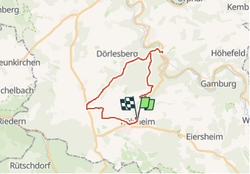
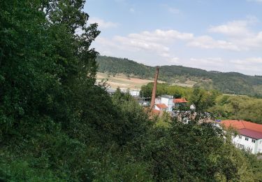
Trail On foot of 21 km to be discovered at Baden-Württemberg, Main-Tauber-Kreis, Külsheim. This trail is proposed by SityTrail - itinéraires balisés pédestres.
Description
Trail created by Tourismusverband „Liebliches Taubertal“.
Symbol: weißes LT 4 auf blauen Grund
Website: https://www.liebliches-taubertal.de/Aktiv/Wandern/Rundwanderungen/Wanderung-Nr-4-Schoenert.html
Positioning
Country:
Germany
Region :
Baden-Württemberg
Department/Province :
Main-Tauber-Kreis
Municipality :
Külsheim
Location:
Unknown
Start:(Dec)
Start:(UTM)
537665 ; 5502133 (32U) N.
Comments
Trails nearby
![Trail On foot Wertheim - Kulturweg Bronnbach Höhefeld - Photo](https://media.geolcdn.com/t/375/260/d419287f-d06a-4f1a-8bf9-699abcc1ffba.jpeg&format=jpg&maxdim=2)
![On foot On foot](https://static1.geolcdn.com/sitytour/trail-icons/100.png)
Kulturweg Bronnbach Höhefeld
On foot
Easy
Wertheim,
Baden-Württemberg,
Main-Tauber-Kreis,
Germany
![](/images/other/stat-length.png)
7.2 km | 10.4 km-effort
2h 21min
![](https://static1.geolcdn.com/siteimages/upload/files/16400158638029165_repeat_loop_refresh_sync_direction_icon.png)
No
![Trail On foot Werbach - Rundwanderweg Gamburg 6 - Photo](https://media.geolcdn.com/t/375/260/83afd43d-bbd6-4c00-a4de-95dd32ba431b.jpeg&format=jpg&maxdim=2)
![On foot On foot](https://static1.geolcdn.com/sitytour/trail-icons/100.png)
Rundwanderweg Gamburg 6
On foot
Easy
Werbach,
Baden-Württemberg,
Main-Tauber-Kreis,
Germany
![](/images/other/stat-length.png)
7.7 km | 10.2 km-effort
2h 19min
![](https://static1.geolcdn.com/siteimages/upload/files/16400158638029165_repeat_loop_refresh_sync_direction_icon.png)
Yes
![Trail On foot Werbach - Rundwanderweg Gamburg 4 - Photo](https://media.geolcdn.com/t/375/260/83afd43d-bbd6-4c00-a4de-95dd32ba431b.jpeg&format=jpg&maxdim=2)
![On foot On foot](https://static1.geolcdn.com/sitytour/trail-icons/100.png)
Rundwanderweg Gamburg 4
On foot
Easy
Werbach,
Baden-Württemberg,
Main-Tauber-Kreis,
Germany
![](/images/other/stat-length.png)
9.5 km | 12.7 km-effort
2h 52min
![](https://static1.geolcdn.com/siteimages/upload/files/16400158638029165_repeat_loop_refresh_sync_direction_icon.png)
Yes