Trail On foot Berching - Wasser- und Mühlenweg - Photo

Tous les sentiers balisés d’Europe GUIDE+

© OpenStreetMap contributors
Length
Length
22 km
Max alt
Max alt
532 m
Uphill gradient
Uphill gradient
643 m
Km-Effort
Km-Effort  
31 km
Min alt
Min alt
366 m
Downhill gradient
Downhill gradient
703 m
Boucle
Boucle
No
Signpost
Signpost
Creation date :
2022-02-11 18:47:45.446
Updated on :
2022-02-11 18:47:45.446

(0 Reviews)

On foot
On foot
7h04
Difficulty : Difficult

Scan this QR Code to open this trail in the SityTrail application

FREE GPS app for hiking

Logo SityTrail SityTrail

IGN / Geographical institutes

Download SityTrail from the App Store Download SityTrail from Google Play

Logo SityTrail SityTrail World

The world is yours!

Download SityTrail from the App Store Download SityTrail from Google Play Download SityTrail on Huawei AppGallery

About

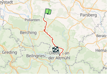
Trail On foot of 22 km to be discovered at Bavaria, Landkreis Neumarkt in der Oberpfalz, Berching. This trail is proposed by SityTrail - itinéraires balisés pédestres.

Description

Trail created by Landkreis Neumarkt i.d.OPf..

Symbol: braunes Mühlrad auf gelben Grund

Elevation profile

Photos

Positioning

Country:
Germany
Region :
Bavaria
Department/Province :
Landkreis Neumarkt in der Oberpfalz
Municipality :
Berching
Location:
Unknown
Start:(UTM)
683339 ; 5447147 (32U) N.

Trails nearby

Trail On foot Berching - Berching - Holnstein - Photo
On foot
GUIDE+

On foot

Easy
Berching, Bavaria, Landkreis Neumarkt in der Oberpfalz, Germany
3.7 km | 4.3 km-effort
58min
No
Trail On foot Berching - Jurasteig König-Ludwig-Schlaufe - Photo
On foot
GUIDE+

On foot

Medium
Berching, Bavaria, Landkreis Neumarkt in der Oberpfalz, Germany
15.9 km | 21 km-effort
4h 40min
No


Close
My subscriptions