![](/images/other/stat-length.png)
![Trail On foot Thierstein - Wanderweg Selb-Thierstein - Photo](https://media.geolcdn.com/t/1900/400/ext.pjpeg?maxdim=2&url=https%3A%2F%2Fmedia.geolcdn.com%2Ff%2F52a3cb25-0e9c-44f3-8a65-56e4d4a9269d.jpeg)
Wanderweg Selb-Thierstein
SityTrail - itinéraires balisés pédestres
Tous les sentiers balisés d’Europe PRO
![Length](/images/other/stat-length.png)
Length
7.8 km
![Max alt](https://static1.geolcdn.com/siteimages/upload/files/1508320355ic_sort_altitude_max_24dp.png)
Max alt
596 m
![Uphill gradient](https://static1.geolcdn.com/siteimages/upload/files/1508320355ic_sort_den_pos_24dp.png)
Uphill gradient
176 m
![Km-Effort](/images/other/stat-length.png)
Km-Effort
10.1 km
![Min alt](https://static1.geolcdn.com/siteimages/upload/files/1508320355ic_sort_altitude_min_24dp.png)
Min alt
498 m
![Downhill gradient](https://static1.geolcdn.com/siteimages/upload/files/1508320355ic_sort_den_neg_24dp.png)
Downhill gradient
170 m
![Boucle](https://static1.geolcdn.com/siteimages/upload/files/16400158638029165_repeat_loop_refresh_sync_direction_icon.png)
Boucle
Yes
Signpost
Creation date :
2022-02-11 18:42:08.048
Updated on :
2022-02-11 18:42:08.048
![On foot](https://static1.geolcdn.com/sitytour/trail-icons/100.png)
2h17
Difficulty : Easy
![Scan this QR Code to open this trail in the SityTrail application](https://capi.geolives.com/qq0zvz2zws4bq2lad0pu/sitytour/trails/3099719/qr.png?size=200)
FREE GPS app for hiking
About
Trail On foot of 7.8 km to be discovered at Bavaria, Landkreis Wunsiedel im Fichtelgebirge, Thierstein. This trail is proposed by SityTrail - itinéraires balisés pédestres.
Description
Trail created by FGV.
Symbol: Blauer Punkt auf weißem Grund
Positioning
Country:
Germany
Region :
Bavaria
Department/Province :
Landkreis Wunsiedel im Fichtelgebirge
Municipality :
Thierstein
Location:
Unknown
Start:(Dec)
Start:(UTM)
292940 ; 5554629 (33U) N.
Comments
Trails nearby
![Trail On foot Thiersheim - Mühlenweg - Photo](https://media.geolcdn.com/t/375/260/ext.jpg?maxdim=2&url=https%3A%2F%2Fmedia.geolcdn.com%2Ff%2F01720f9c-a96f-46fd-a209-317713a1cbaa.jpeg)
![On foot On foot](https://static1.geolcdn.com/sitytour/trail-icons/100.png)
Mühlenweg
On foot
Easy
Thiersheim,
Bavaria,
Landkreis Wunsiedel im Fichtelgebirge,
Germany
![](/images/other/stat-length.png)
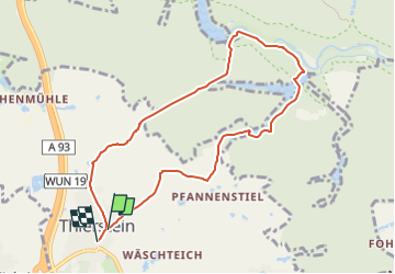
6.9 km | 7.9 km-effort
1h 48min
![](https://static1.geolcdn.com/siteimages/upload/files/16400158638029165_repeat_loop_refresh_sync_direction_icon.png)
No
![Trail On foot Thierstein - Schwarzenbach/Saale-Thierstein - Photo](https://media.geolcdn.com/t/375/260/ext.jpg?maxdim=2&url=https%3A%2F%2Fmedia.geolcdn.com%2Ff%2F5f4c0deb-0530-4ce1-bd74-b7b74cba2131.jpeg)
![On foot On foot](https://static1.geolcdn.com/sitytour/trail-icons/100.png)
Schwarzenbach/Saale-Thierstein
On foot
Medium
Thierstein,
Bavaria,
Landkreis Wunsiedel im Fichtelgebirge,
Germany
![](/images/other/stat-length.png)
22 km | 29 km-effort
6h 34min
![](https://static1.geolcdn.com/siteimages/upload/files/16400158638029165_repeat_loop_refresh_sync_direction_icon.png)
No
![Trail On foot Thiersheim - Wanderweg 4 Thiersheim - Photo](https://media.geolcdn.com/t/375/260/ext.jpg?maxdim=2&url=https%3A%2F%2Fmedia.geolcdn.com%2Ff%2F2965c40e-d840-49a2-8722-f73dd83526d7.jpeg)
![On foot On foot](https://static1.geolcdn.com/sitytour/trail-icons/100.png)
Wanderweg 4 Thiersheim
On foot
Easy
Thiersheim,
Bavaria,
Landkreis Wunsiedel im Fichtelgebirge,
Germany
![](/images/other/stat-length.png)
5.6 km | 6.8 km-effort
1h 33min
![](https://static1.geolcdn.com/siteimages/upload/files/16400158638029165_repeat_loop_refresh_sync_direction_icon.png)
No
![Trail On foot Selb - 3 [Selb] - Photo](https://media.geolcdn.com/t/375/260/ext.jpg?maxdim=2&url=https%3A%2F%2Fmedia.geolcdn.com%2Ff%2Fa65d9baa-5712-430b-ad9a-ce39442ae678.jpeg)
![On foot On foot](https://static1.geolcdn.com/sitytour/trail-icons/100.png)
3 [Selb]
On foot
Easy
Selb,
Bavaria,
Landkreis Wunsiedel im Fichtelgebirge,
Germany
![](/images/other/stat-length.png)
6.4 km | 8.2 km-effort
1h 51min
![](https://static1.geolcdn.com/siteimages/upload/files/16400158638029165_repeat_loop_refresh_sync_direction_icon.png)
Yes
![Trail On foot Thierstein - Wanderweg 2 Thierstein - Photo](https://media.geolcdn.com/t/375/260/ext.jpg?maxdim=2&url=https%3A%2F%2Fstatic1.geolcdn.com%2Fsiteimages%2Fupload%2Ffiles%2F1545311037marcheuse_200dpi.jpg)
![On foot On foot](https://static1.geolcdn.com/sitytour/trail-icons/100.png)
Wanderweg 2 Thierstein
On foot
Easy
Thierstein,
Bavaria,
Landkreis Wunsiedel im Fichtelgebirge,
Germany
![](/images/other/stat-length.png)
7 km | 8.6 km-effort
1h 57min
![](https://static1.geolcdn.com/siteimages/upload/files/16400158638029165_repeat_loop_refresh_sync_direction_icon.png)
Yes
![Trail On foot Thierstein - Wanderweg 1 Thierstein - Photo](https://media.geolcdn.com/t/375/260/ext.jpg?maxdim=2&url=https%3A%2F%2Fstatic1.geolcdn.com%2Fsiteimages%2Fupload%2Ffiles%2F1545311037marcheuse_200dpi.jpg)
![On foot On foot](https://static1.geolcdn.com/sitytour/trail-icons/100.png)
Wanderweg 1 Thierstein
On foot
Easy
Thierstein,
Bavaria,
Landkreis Wunsiedel im Fichtelgebirge,
Germany
![](/images/other/stat-length.png)
7.8 km | 10.1 km-effort
2h 17min
![](https://static1.geolcdn.com/siteimages/upload/files/16400158638029165_repeat_loop_refresh_sync_direction_icon.png)
Yes
![Trail On foot Wunsiedel - Rundwanderweg Göpfersgrün - Photo](https://media.geolcdn.com/t/375/260/ext.jpg?maxdim=2&url=https%3A%2F%2Fstatic1.geolcdn.com%2Fsiteimages%2Fupload%2Ffiles%2F1545311037marcheuse_200dpi.jpg)
![On foot On foot](https://static1.geolcdn.com/sitytour/trail-icons/100.png)
Rundwanderweg Göpfersgrün
On foot
Easy
Wunsiedel,
Bavaria,
Landkreis Wunsiedel im Fichtelgebirge,
Germany
![](/images/other/stat-length.png)
3.7 km | 4.6 km-effort
1h 2min
![](https://static1.geolcdn.com/siteimages/upload/files/16400158638029165_repeat_loop_refresh_sync_direction_icon.png)
No
![Trail On foot Marktleuthen - Wanderroute Zubringer Fränkischer Gebirgsweg (Marktleuthen) - Photo](https://media.geolcdn.com/t/375/260/ext.jpg?maxdim=2&url=https%3A%2F%2Fstatic1.geolcdn.com%2Fsiteimages%2Fupload%2Ffiles%2F1545311037marcheuse_200dpi.jpg)
![On foot On foot](https://static1.geolcdn.com/sitytour/trail-icons/100.png)
Wanderroute Zubringer Fränkischer Gebirgsweg (Marktleuthen)
On foot
Easy
Marktleuthen,
Bavaria,
Landkreis Wunsiedel im Fichtelgebirge,
Germany
![](/images/other/stat-length.png)
3.8 km | 4.9 km-effort
1h 6min
![](https://static1.geolcdn.com/siteimages/upload/files/16400158638029165_repeat_loop_refresh_sync_direction_icon.png)
No
![Trail On foot Thierstein - Wanderroute Schönwald-Schwarzenhammer - Photo](https://media.geolcdn.com/t/375/260/ext.jpg?maxdim=2&url=https%3A%2F%2Fstatic1.geolcdn.com%2Fsiteimages%2Fupload%2Ffiles%2F1545311037marcheuse_200dpi.jpg)
![On foot On foot](https://static1.geolcdn.com/sitytour/trail-icons/100.png)
Wanderroute Schönwald-Schwarzenhammer
On foot
Easy
Thierstein,
Bavaria,
Landkreis Wunsiedel im Fichtelgebirge,
Germany
![](/images/other/stat-length.png)
8.8 km | 11.4 km-effort
2h 35min
![](https://static1.geolcdn.com/siteimages/upload/files/16400158638029165_repeat_loop_refresh_sync_direction_icon.png)
No