Trail On foot Auetal - Bergmannsweg - Photo

Tous les sentiers balisés d’Europe PRO

© OpenStreetMap contributors
Length
Length
22 km
Max alt
Max alt
288 m
Uphill gradient
Uphill gradient
500 m
Km-Effort
Km-Effort  
29 km
Min alt
Min alt
96 m
Downhill gradient
Downhill gradient
508 m
Boucle
Boucle
No
Signpost
Signpost
Creation date :
2022-02-11 18:35:42.524
Updated on :
2022-02-11 18:35:42.524

(0 Reviews)

On foot
On foot
6h35
Difficulty : Medium

Scan this QR Code to open this trail in the SityTrail application

FREE GPS app for hiking

Logo SityTrail SityTrail

IGN / Geographical institutes

Download SityTrail from the App Store Download SityTrail from Google Play

Logo SityTrail SityTrail World

The world is yours!

Download SityTrail from the App Store Download SityTrail from Google Play Download SityTrail on Huawei AppGallery

About

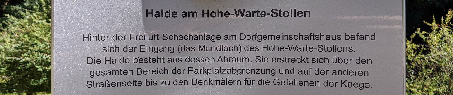
Trail On foot of 22 km to be discovered at Lower Saxony, Landkreis Schaumburg, Auetal. This trail is proposed by SityTrail - itinéraires balisés pédestres.

Description

Symbol: schwarzer Bergmann und schwarze Schlägel und Eisen auf gelbem Grund


Website: http://www.coppenbruegge.de/assets/templates/copp/downloads/Bergmannsweg.pdf

Photos

Positioning

Country:
Germany
Region :
Lower Saxony
Department/Province :
Landkreis Schaumburg
Municipality :
Auetal
Location:
Unknown
Start:(UTM)
531965 ; 5780955 (32U) N.

Trails nearby

Trail On foot Auetal - Kurterrainweg 2 im Osterberg - Photo
On foot
PRO

On foot

Easy
Auetal, Lower Saxony, Landkreis Schaumburg, Germany
3.6 km | 4.6 km-effort
1h 2min
No
Trail On foot Auetal - Kurterrainweg 3 im Osterberg - Photo
On foot
PRO

On foot

Easy
Auetal, Lower Saxony, Landkreis Schaumburg, Germany
5.3 km | 6.6 km-effort
1h 30min
Yes


Close
My subscriptions