![](/images/other/stat-length.png)
![Trail On foot Holzminden - LLR - Hochmoor - Photo](https://media.geolcdn.com/t/1900/400/50629b99-de57-4793-81da-65a23924f6bf.jpeg&format=pjpeg&maxdim=2)
LLR - Hochmoor
SityTrail - itinéraires balisés pédestres
Tous les sentiers balisés d’Europe GUIDE+
![Length](/images/other/stat-length.png)
Length
6.2 km
![Max alt](https://static1.geolcdn.com/siteimages/upload/files/1508320355ic_sort_altitude_max_24dp.png)
Max alt
493 m
![Uphill gradient](https://static1.geolcdn.com/siteimages/upload/files/1508320355ic_sort_den_pos_24dp.png)
Uphill gradient
89 m
![Km-Effort](/images/other/stat-length.png)
Km-Effort
7.4 km
![Min alt](https://static1.geolcdn.com/siteimages/upload/files/1508320355ic_sort_altitude_min_24dp.png)
Min alt
449 m
![Downhill gradient](https://static1.geolcdn.com/siteimages/upload/files/1508320355ic_sort_den_neg_24dp.png)
Downhill gradient
89 m
![Boucle](https://static1.geolcdn.com/siteimages/upload/files/16400158638029165_repeat_loop_refresh_sync_direction_icon.png)
Boucle
Yes
Signpost
Creation date :
2022-02-11 18:01:24.062
Updated on :
2022-02-11 18:01:24.062
![On foot](https://static1.geolcdn.com/sitytour/trail-icons/100.png)
1h40
Difficulty : Easy
![Scan this QR Code to open this trail in the SityTrail application](https://capi.geolives.com/qq0zvz2zws4bq2lad0pu/sitytour/trails/3098931/qr.png?size=200)
FREE GPS app for hiking
About
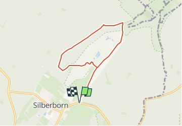
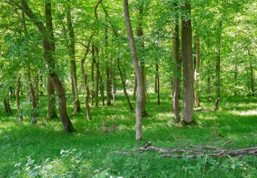
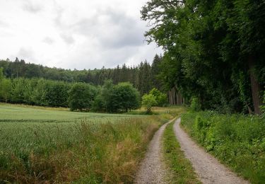
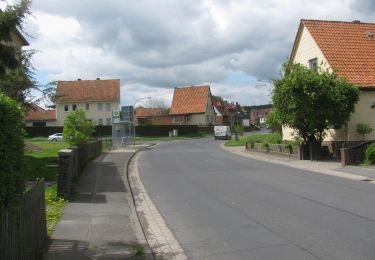
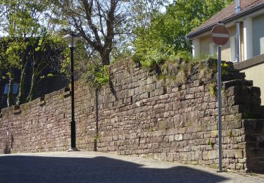
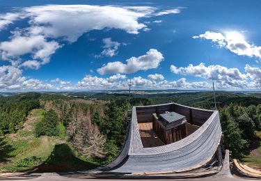
Trail On foot of 6.2 km to be discovered at Lower Saxony, Landkreis Holzminden, Holzminden. This trail is proposed by SityTrail - itinéraires balisés pédestres.
Description
Trail created by Naturpark Solling-Vogler.
Website: https://www.naturpark-solling-vogler.de/index.php/hochmoor.html
Positioning
Country:
Germany
Region :
Lower Saxony
Department/Province :
Landkreis Holzminden
Municipality :
Holzminden
Location:
Unknown
Start:(Dec)
Start:(UTM)
538072 ; 5735665 (32U) N.
Comments
Trails nearby
![Trail On foot Höxter - Erlesene Natur - Dem Wasserdrachen auf der Spur - Photo](https://media.geolcdn.com/t/375/260/68c2e4a4-4b61-444a-8447-529c1e1368f8.jpeg&format=jpg&maxdim=2)
![On foot On foot](https://static1.geolcdn.com/sitytour/trail-icons/100.png)
Erlesene Natur - Dem Wasserdrachen auf der Spur
On foot
Easy
Höxter,
North Rhine-Westphalia,
Kreis Höxter,
Germany
![](/images/other/stat-length.png)
10.6 km | 15 km-effort
3h 24min
![](https://static1.geolcdn.com/siteimages/upload/files/16400158638029165_repeat_loop_refresh_sync_direction_icon.png)
No
![Trail On foot Höxter - Erlesene Natur - Zu Besuch im Paradies - Photo](https://media.geolcdn.com/t/375/260/de0f457c-48bd-4e82-a2b8-9fdcc1ce0413.jpeg&format=jpg&maxdim=2)
![On foot On foot](https://static1.geolcdn.com/sitytour/trail-icons/100.png)
Erlesene Natur - Zu Besuch im Paradies
On foot
Easy
Höxter,
North Rhine-Westphalia,
Kreis Höxter,
Germany
![](/images/other/stat-length.png)
5.2 km | 6.8 km-effort
1h 32min
![](https://static1.geolcdn.com/siteimages/upload/files/16400158638029165_repeat_loop_refresh_sync_direction_icon.png)
No
![Trail On foot Beverungen - Weserhöhen-Wanderung](https://media.geolcdn.com/t/375/260/f74506ea-cb13-499e-a0c5-faf54c71f6da.jpeg&format=jpg&maxdim=2)
![On foot On foot](https://static1.geolcdn.com/sitytour/trail-icons/100.png)
Weserhöhen-Wanderung "Rund um den Heineberg"
On foot
Easy
Beverungen,
North Rhine-Westphalia,
Kreis Höxter,
Germany
![](/images/other/stat-length.png)
6.5 km | 9 km-effort
2h 3min
![](https://static1.geolcdn.com/siteimages/upload/files/16400158638029165_repeat_loop_refresh_sync_direction_icon.png)
Yes
![Trail On foot Beverungen - Weserhöhen-Wanderung](https://media.geolcdn.com/t/375/260/0f1ce3b5-1a27-4864-b0fd-1bb0d7e004d7.jpeg&format=jpg&maxdim=2)
![On foot On foot](https://static1.geolcdn.com/sitytour/trail-icons/100.png)
Weserhöhen-Wanderung "Die Blankenauer Runde durch Hegge und Wildberg"
On foot
Easy
Beverungen,
North Rhine-Westphalia,
Kreis Höxter,
Germany
![](/images/other/stat-length.png)
7.5 km | 10.2 km-effort
2h 18min
![](https://static1.geolcdn.com/siteimages/upload/files/16400158638029165_repeat_loop_refresh_sync_direction_icon.png)
No
![Trail On foot Beverungen - Weserhöhen-Wanderung](https://media.geolcdn.com/t/375/260/0f1ce3b5-1a27-4864-b0fd-1bb0d7e004d7.jpeg&format=jpg&maxdim=2)
![On foot On foot](https://static1.geolcdn.com/sitytour/trail-icons/100.png)
Weserhöhen-Wanderung "Rund um den Wildberg"
On foot
Easy
Beverungen,
North Rhine-Westphalia,
Kreis Höxter,
Germany
![](/images/other/stat-length.png)
8.7 km | 11.8 km-effort
2h 40min
![](https://static1.geolcdn.com/siteimages/upload/files/16400158638029165_repeat_loop_refresh_sync_direction_icon.png)
No
![Trail On foot Adelebsen - Rundwanderweg Adelebsen 2 - Photo](https://media.geolcdn.com/t/375/260/35b9f4af-406d-4289-bd78-88006f685380.jpeg&format=jpg&maxdim=2)
![On foot On foot](https://static1.geolcdn.com/sitytour/trail-icons/100.png)
Rundwanderweg Adelebsen 2
On foot
Easy
Adelebsen,
Lower Saxony,
Landkreis Göttingen,
Germany
![](/images/other/stat-length.png)
6.7 km | 9.1 km-effort
2h 3min
![](https://static1.geolcdn.com/siteimages/upload/files/16400158638029165_repeat_loop_refresh_sync_direction_icon.png)
Yes
![Trail On foot Stadtoldendorf - ST2 Durchs Fahrenbachtal zum Klostergut - Photo](https://media.geolcdn.com/t/375/260/bbee21e9-2227-4f7c-8d2f-d75e4e358977.jpeg&format=jpg&maxdim=2)
![On foot On foot](https://static1.geolcdn.com/sitytour/trail-icons/100.png)
ST2 Durchs Fahrenbachtal zum Klostergut
On foot
Easy
Stadtoldendorf,
Lower Saxony,
Landkreis Holzminden,
Germany
![](/images/other/stat-length.png)
6.1 km | 7.5 km-effort
1h 42min
![](https://static1.geolcdn.com/siteimages/upload/files/16400158638029165_repeat_loop_refresh_sync_direction_icon.png)
Yes
![Trail On foot Stadtoldendorf - ST1Klostertour - Photo](https://media.geolcdn.com/t/375/260/bbee21e9-2227-4f7c-8d2f-d75e4e358977.jpeg&format=jpg&maxdim=2)
![On foot On foot](https://static1.geolcdn.com/sitytour/trail-icons/100.png)
ST1Klostertour
On foot
Easy
Stadtoldendorf,
Lower Saxony,
Landkreis Holzminden,
Germany
![](/images/other/stat-length.png)
3.8 km | 4.6 km-effort
1h 3min
![](https://static1.geolcdn.com/siteimages/upload/files/16400158638029165_repeat_loop_refresh_sync_direction_icon.png)
Yes
![Trail On foot Kirchbrak - GO1 Wilder Vogler - Photo](https://media.geolcdn.com/t/375/260/a276c1c2-bcf8-4614-ab80-a97bc9214cd6.jpeg&format=jpg&maxdim=2)
![On foot On foot](https://static1.geolcdn.com/sitytour/trail-icons/100.png)
GO1 Wilder Vogler
On foot
Easy
Kirchbrak,
Lower Saxony,
Landkreis Holzminden,
Germany
![](/images/other/stat-length.png)
7.8 km | 11.6 km-effort
2h 38min
![](https://static1.geolcdn.com/siteimages/upload/files/16400158638029165_repeat_loop_refresh_sync_direction_icon.png)
Yes