


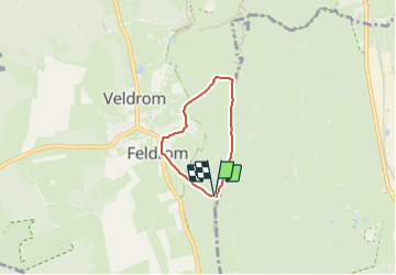

14.6 km | 19.1 km-effort
![Trail On foot Horn-Bad Meinberg - Rundwanderweg A2 [Feldrom] - Photo](https://media.geolcdn.com/t/1900/400/82208e22-56ad-4715-9507-28234728434e.jpeg&format=pjpeg&maxdim=2)

Tous les sentiers balisés d’Europe GUIDE+


FREE GPS app for hiking
 SityTrail
IGN / Geographical institutes
SityTrail World
The world is yours!
Trail On foot of 3.4 km to be discovered at North Rhine-Westphalia, Kreis Lippe, Horn-Bad Meinberg. This trail is proposed by SityTrail - itinéraires balisés pédestres.
Symbol: weiße Schrift "A2" auf schwarzen Grund
![Trail On foot Horn-Bad Meinberg - Rundwanderweg A2 [Feldrom] - Photo 1](https://media.geolcdn.com/t/2048/auto/f1d805ed-b8c5-4f7b-b47a-a7ee0d956cd1.jpeg&format=jpg&maxdim=0 "Trail On foot Horn-Bad Meinberg - Rundwanderweg A2 [Feldrom] - Photo 1")
![Trail On foot Horn-Bad Meinberg - Rundwanderweg A2 [Feldrom] - Photo 2](https://media.geolcdn.com/t/2048/auto/5f6e4d65-e40a-4e17-af6a-cba9fdc5e7c1.jpeg&format=jpg&maxdim=0 "Trail On foot Horn-Bad Meinberg - Rundwanderweg A2 [Feldrom] - Photo 2")
![Trail On foot Horn-Bad Meinberg - Rundwanderweg A2 [Feldrom] - Photo 3](https://media.geolcdn.com/t/2048/auto/8250f265-16a8-45ab-8e8f-363f580e3d2a.jpeg&format=jpg&maxdim=0 "Trail On foot Horn-Bad Meinberg - Rundwanderweg A2 [Feldrom] - Photo 3")
![Trail On foot Horn-Bad Meinberg - Rundwanderweg A2 [Feldrom] - Photo 4](https://media.geolcdn.com/t/2048/auto/1e7345e4-75ee-4a47-a1e3-abec91429b51.jpeg&format=jpg&maxdim=0 "Trail On foot Horn-Bad Meinberg - Rundwanderweg A2 [Feldrom] - Photo 4")
![Trail On foot Horn-Bad Meinberg - Rundwanderweg A2 [Feldrom] - Photo 5](https://media.geolcdn.com/t/2048/auto/08f7e8ee-9be2-4611-981a-2d5c0bb620ec.jpeg&format=jpg&maxdim=0 "Trail On foot Horn-Bad Meinberg - Rundwanderweg A2 [Feldrom] - Photo 5")
![Trail On foot Horn-Bad Meinberg - Rundwanderweg A2 [Feldrom] - Photo 6](https://media.geolcdn.com/t/2048/auto/1b5feaf3-00e2-49ef-826f-9c22422f0082.jpeg&format=jpg&maxdim=0 "Trail On foot Horn-Bad Meinberg - Rundwanderweg A2 [Feldrom] - Photo 6")
![Trail On foot Horn-Bad Meinberg - Rundwanderweg A2 [Feldrom] - Photo 7](https://media.geolcdn.com/t/2048/auto/63009bc4-c708-49e8-910f-38c0a1283284.jpeg&format=jpg&maxdim=0 "Trail On foot Horn-Bad Meinberg - Rundwanderweg A2 [Feldrom] - Photo 7")
![Trail On foot Horn-Bad Meinberg - Rundwanderweg A2 [Feldrom] - Photo 8](https://media.geolcdn.com/t/2048/auto/df6ae4b3-3e09-4c25-b933-753e30d136ba.jpeg&format=jpg&maxdim=0 "Trail On foot Horn-Bad Meinberg - Rundwanderweg A2 [Feldrom] - Photo 8")
![Trail On foot Horn-Bad Meinberg - Rundwanderweg A2 [Feldrom] - Photo 9](https://media.geolcdn.com/t/2048/auto/82208e22-56ad-4715-9507-28234728434e.jpeg&format=jpg&maxdim=0 "Trail On foot Horn-Bad Meinberg - Rundwanderweg A2 [Feldrom] - Photo 9")
![Trail On foot Horn-Bad Meinberg - Rundwanderweg A2 [Feldrom] - Photo 10](https://media.geolcdn.com/t/2048/auto/6994dd42-5999-465d-9ad7-eb4110c6119d.jpeg&format=jpg&maxdim=0 "Trail On foot Horn-Bad Meinberg - Rundwanderweg A2 [Feldrom] - Photo 10")
On foot
On foot
On foot
On foot
On foot
![Trail On foot Horn-Bad Meinberg - Rundwanderweg A4 [Feldrom] - Photo](https://media.geolcdn.com/t/375/260/c3e2fda2-4a4b-4515-b251-ad31aeb36002.jpeg&format=jpg&maxdim=2)
On foot
![Trail On foot Steinheim - Rundwanderweg A1 [Grevenhagen] - Photo](https://media.geolcdn.com/t/375/260/202ac17e-dbff-44d1-b3d9-93eb341f466c.jpeg&format=jpg&maxdim=2)
On foot
![Trail On foot Schlangen - Rundwanderweg 34 [Barnacken] - Photo](https://media.geolcdn.com/t/375/260/83e8c965-88dc-4fa7-9331-4da86113c518.jpeg&format=jpg&maxdim=2)
On foot
![Trail On foot Horn-Bad Meinberg - Rundwanderweg A5 [Horn] - Photo](https://media.geolcdn.com/t/375/260/4fb4c3bc-36b1-4cb9-b69c-377d560ed1e3.jpeg&format=jpg&maxdim=2)
On foot