![](/images/other/stat-length.png)
![Trail On foot Gomadingen - Hohenzollernweg - Alternative Killer - und weiter - Photo](https://media.geolcdn.com/t/1900/400/563097f2-1870-4429-88e7-342bfb315121.jpeg&format=pjpeg&maxdim=2)
Hohenzollernweg - Alternative Killer - und weiter
SityTrail - itinéraires balisés pédestres
Tous les sentiers balisés d’Europe GUIDE+
![Length](/images/other/stat-length.png)
Length
6.7 km
![Max alt](https://static1.geolcdn.com/siteimages/upload/files/1508320355ic_sort_altitude_max_24dp.png)
Max alt
839 m
![Uphill gradient](https://static1.geolcdn.com/siteimages/upload/files/1508320355ic_sort_den_pos_24dp.png)
Uphill gradient
221 m
![Km-Effort](/images/other/stat-length.png)
Km-Effort
9.2 km
![Min alt](https://static1.geolcdn.com/siteimages/upload/files/1508320355ic_sort_altitude_min_24dp.png)
Min alt
698 m
![Downhill gradient](https://static1.geolcdn.com/siteimages/upload/files/1508320355ic_sort_den_neg_24dp.png)
Downhill gradient
83 m
![Boucle](https://static1.geolcdn.com/siteimages/upload/files/16400158638029165_repeat_loop_refresh_sync_direction_icon.png)
Boucle
No
Signpost
Creation date :
2022-02-11 17:54:36.599
Updated on :
2022-02-11 17:54:36.599
![On foot](https://static1.geolcdn.com/sitytour/trail-icons/100.png)
2h05
Difficulty : Easy
![Scan this QR Code to open this trail in the SityTrail application](https://capi.geolives.com/qq0zvz2zws4bq2lad0pu/sitytour/trails/3098744/qr.png?size=200)
FREE GPS app for hiking
About
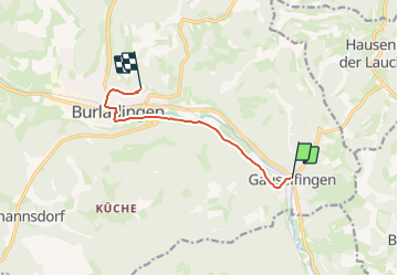
Trail On foot of 6.7 km to be discovered at Baden-Württemberg, Landkreis Reutlingen, Gomadingen. This trail is proposed by SityTrail - itinéraires balisés pédestres.
Description
Trail created by Landratsamt Balingen.
Symbol: Black tower with coat of arms on white Background (All Black and white)
Positioning
Country:
Germany
Region :
Baden-Württemberg
Department/Province :
Landkreis Reutlingen
Municipality :
Gomadingen
Location:
Unknown
Start:(Dec)
Start:(UTM)
512441 ; 5346924 (32U) N.
Comments
Trails nearby
![Trail On foot Gomadingen - Zugangsweg Ringingen - Burladingen - Hauptstraße Gauselfingen - Photo](https://media.geolcdn.com/t/375/260/5a152196-09e6-4f45-835b-18aba79f9fe7.jpeg&format=jpg&maxdim=2)
![On foot On foot](https://static1.geolcdn.com/sitytour/trail-icons/100.png)
Zugangsweg Ringingen - Burladingen - Hauptstraße Gauselfingen
On foot
Easy
Gomadingen,
Baden-Württemberg,
Landkreis Reutlingen,
Germany
![](/images/other/stat-length.png)
14 km | 19.5 km-effort
4h 26min
![](https://static1.geolcdn.com/siteimages/upload/files/16400158638029165_repeat_loop_refresh_sync_direction_icon.png)
No
![Trail On foot Gomadingen - Innerer Zugangsweg Schwäbischen Albvereins (gelbes Dreieck) - Photo](https://media.geolcdn.com/t/375/260/fb32a524-eb02-4fde-a738-191540380286.jpeg&format=jpg&maxdim=2)
![On foot On foot](https://static1.geolcdn.com/sitytour/trail-icons/100.png)
Innerer Zugangsweg Schwäbischen Albvereins (gelbes Dreieck)
On foot
Easy
Gomadingen,
Baden-Württemberg,
Landkreis Reutlingen,
Germany
![](/images/other/stat-length.png)
11.6 km | 13.7 km-effort
3h 7min
![](https://static1.geolcdn.com/siteimages/upload/files/16400158638029165_repeat_loop_refresh_sync_direction_icon.png)
No
![Trail On foot Gomadingen - Zugangsweg - Bärenhöhle Erpfingen Hörschwang Bronnen - Photo](https://media.geolcdn.com/t/375/260/5dd1616d-f3bb-4d18-871b-b2dc57846d90.jpeg&format=jpg&maxdim=2)
![On foot On foot](https://static1.geolcdn.com/sitytour/trail-icons/100.png)
Zugangsweg - Bärenhöhle Erpfingen Hörschwang Bronnen
On foot
Easy
Gomadingen,
Baden-Württemberg,
Landkreis Reutlingen,
Germany
![](/images/other/stat-length.png)
5.8 km | 7.8 km-effort
1h 45min
![](https://static1.geolcdn.com/siteimages/upload/files/16400158638029165_repeat_loop_refresh_sync_direction_icon.png)
No