


3.7 km | 4.4 km-effort
![Trail On foot Detmold - Rundwanderweg A1 [Berlebeck] - Photo](https://media.geolcdn.com/t/1900/400/09e96dc8-2a72-420e-af43-8a0b6d458613.jpeg&format=pjpeg&maxdim=2)

Tous les sentiers balisés d’Europe GUIDE+


FREE GPS app for hiking
 SityTrail
IGN / Geographical institutes
SityTrail World
The world is yours!
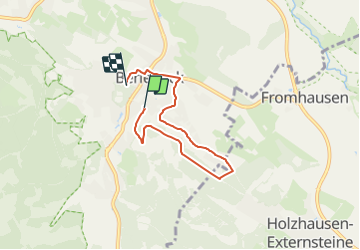
Trail On foot of 4.5 km to be discovered at North Rhine-Westphalia, Kreis Lippe, Detmold. This trail is proposed by SityTrail - itinéraires balisés pédestres.
Trail created by Lippischer Heimatverein.
![Trail On foot Detmold - Rundwanderweg A1 [Berlebeck] - Photo 1](https://media.geolcdn.com/t/2048/auto/49a5d789-31b8-4fde-a22c-d45f036dc447.jpeg&format=jpg&maxdim=0 "Trail On foot Detmold - Rundwanderweg A1 [Berlebeck] - Photo 1")
![Trail On foot Detmold - Rundwanderweg A1 [Berlebeck] - Photo 2](https://media.geolcdn.com/t/2048/auto/0e0e24ec-5b30-4627-9083-38418d2ea301.jpeg&format=jpg&maxdim=0 "Trail On foot Detmold - Rundwanderweg A1 [Berlebeck] - Photo 2")
![Trail On foot Detmold - Rundwanderweg A1 [Berlebeck] - Photo 3](https://media.geolcdn.com/t/2048/auto/5ec83b38-3fc9-4d1d-a243-82bfe473e85b.jpeg&format=jpg&maxdim=0 "Trail On foot Detmold - Rundwanderweg A1 [Berlebeck] - Photo 3")
![Trail On foot Detmold - Rundwanderweg A1 [Berlebeck] - Photo 4](https://media.geolcdn.com/t/2048/auto/3c91ec98-bf47-4e4a-8194-a19c819bbb39.jpeg&format=jpg&maxdim=0 "Trail On foot Detmold - Rundwanderweg A1 [Berlebeck] - Photo 4")
![Trail On foot Detmold - Rundwanderweg A1 [Berlebeck] - Photo 5](https://media.geolcdn.com/t/2048/auto/09e96dc8-2a72-420e-af43-8a0b6d458613.jpeg&format=jpg&maxdim=0 "Trail On foot Detmold - Rundwanderweg A1 [Berlebeck] - Photo 5")
![Trail On foot Detmold - Rundwanderweg A1 [Berlebeck] - Photo 6](https://media.geolcdn.com/t/2048/auto/a10ffad1-a998-4ee3-ae03-506206f2cb15.jpeg&format=jpg&maxdim=0 "Trail On foot Detmold - Rundwanderweg A1 [Berlebeck] - Photo 6")
![Trail On foot Detmold - Rundwanderweg A1 [Berlebeck] - Photo 7](https://media.geolcdn.com/t/2048/auto/dc09c2c8-da64-4d5f-b357-677a2d46a09e.jpeg&format=jpg&maxdim=0 "Trail On foot Detmold - Rundwanderweg A1 [Berlebeck] - Photo 7")
![Trail On foot Detmold - Rundwanderweg A1 [Berlebeck] - Photo 8](https://media.geolcdn.com/t/2048/auto/daad2907-f967-40bf-9ffe-8a50d3c9aae1.jpeg&format=jpg&maxdim=0 "Trail On foot Detmold - Rundwanderweg A1 [Berlebeck] - Photo 8")
![Trail On foot Detmold - Rundwanderweg A1 [Berlebeck] - Photo 9](https://media.geolcdn.com/t/2048/auto/9624b63f-e63d-4566-afac-fe6174b35d1f.jpeg&format=jpg&maxdim=0 "Trail On foot Detmold - Rundwanderweg A1 [Berlebeck] - Photo 9")
![Trail On foot Detmold - Rundwanderweg A1 [Berlebeck] - Photo 10](https://media.geolcdn.com/t/2048/auto/71cab782-88c9-4172-a0bb-5010de69666e.jpeg&format=jpg&maxdim=0 "Trail On foot Detmold - Rundwanderweg A1 [Berlebeck] - Photo 10")
On foot
![Trail On foot Detmold - Rundwanderweg A5 [Berlebeck] - Photo](https://media.geolcdn.com/t/375/260/09e96dc8-2a72-420e-af43-8a0b6d458613.jpeg&format=jpg&maxdim=2)
On foot
On foot
![Trail On foot Horn-Bad Meinberg - Rundwanderweg A1 [Holzhausen-Externsteine] - Photo](https://media.geolcdn.com/t/375/260/917c6440-8043-45d4-9c08-101f3367a522.jpeg&format=jpg&maxdim=2)
On foot
![Trail On foot Detmold - Rundwanderweg [Gauseköte] - Photo](https://media.geolcdn.com/t/375/260/b23ec4a7-b5cb-44c3-a014-f0b25ad95715.jpeg&format=jpg&maxdim=2)
On foot
![Trail On foot Schlangen - Rundwanderweg 34 [Barnacken] - Photo](https://media.geolcdn.com/t/375/260/83e8c965-88dc-4fa7-9331-4da86113c518.jpeg&format=jpg&maxdim=2)
On foot
![Trail On foot Horn-Bad Meinberg - Rundwanderweg A5 [Horn] - Photo](https://media.geolcdn.com/t/375/260/4fb4c3bc-36b1-4cb9-b69c-377d560ed1e3.jpeg&format=jpg&maxdim=2)
On foot
![Trail On foot Horn-Bad Meinberg - Rundwanderweg A2 [Holzhausen-Externsteine] - Photo](https://media.geolcdn.com/t/375/260/496f2643-585c-4ec3-ad5f-48d37358ba78.jpeg&format=jpg&maxdim=2)
On foot
On foot