![](/images/other/stat-length.png)
![Trail On foot Püttlingen - Pfarrer-Rug-Weg - Photo](https://media.geolcdn.com/t/1900/400/ext.pjpeg?maxdim=2&url=https%3A%2F%2Fmedia.geolcdn.com%2Ff%2F35199d78-db73-436a-8685-d67217d3ea79.jpeg)
Pfarrer-Rug-Weg
SityTrail - itinéraires balisés pédestres
Tous les sentiers balisés d’Europe PRO
![Length](/images/other/stat-length.png)
Length
41 km
![Max alt](https://static1.geolcdn.com/siteimages/upload/files/1508320355ic_sort_altitude_max_24dp.png)
Max alt
400 m
![Uphill gradient](https://static1.geolcdn.com/siteimages/upload/files/1508320355ic_sort_den_pos_24dp.png)
Uphill gradient
987 m
![Km-Effort](/images/other/stat-length.png)
Km-Effort
54 km
![Min alt](https://static1.geolcdn.com/siteimages/upload/files/1508320355ic_sort_altitude_min_24dp.png)
Min alt
201 m
![Downhill gradient](https://static1.geolcdn.com/siteimages/upload/files/1508320355ic_sort_den_neg_24dp.png)
Downhill gradient
986 m
![Boucle](https://static1.geolcdn.com/siteimages/upload/files/16400158638029165_repeat_loop_refresh_sync_direction_icon.png)
Boucle
Yes
Signpost
Creation date :
2022-02-11 17:46:43.639
Updated on :
2022-02-11 17:46:43.639
![On foot](https://static1.geolcdn.com/sitytour/trail-icons/100.png)
12h15
Difficulty : Very difficult
![Scan this QR Code to open this trail in the SityTrail application](https://capi.geolives.com/qq0zvz2zws4bq2lad0pu/sitytour/trails/3098513/qr.png?size=200)
FREE GPS app for hiking
About
Trail On foot of 41 km to be discovered at Saarland, Regionalverband Saarbrücken, Püttlingen. This trail is proposed by SityTrail - itinéraires balisés pédestres.
Description
Eurodistrict SaarMoselle
Website: http://www.vianovis.net/saarmoselle/#SOURCE=saarmoselle-touren&FID=64&m=satellite&zoomto=true
Positioning
Country:
Germany
Region :
Saarland
Department/Province :
Regionalverband Saarbrücken
Municipality :
Püttlingen
Location:
Köllerbach
Start:(Dec)
Start:(UTM)
347093 ; 5465064 (32U) N.
Comments
Trails nearby
![Trail On foot Püttlingen - Haldenrundweg Südschleife - Photo](https://media.geolcdn.com/t/375/260/ext.jpg?maxdim=2&url=https%3A%2F%2Fmedia.geolcdn.com%2Ff%2Fa8fb5704-6d35-4e87-bda8-aa7d53c655e6.jpeg)
![On foot On foot](https://static1.geolcdn.com/sitytour/trail-icons/100.png)
Haldenrundweg Südschleife
On foot
Easy
Püttlingen,
Saarland,
Regionalverband Saarbrücken,
Germany
![](/images/other/stat-length.png)
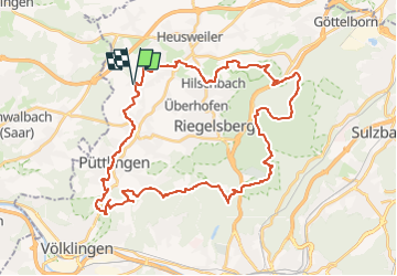
9.8 km | 12.2 km-effort
2h 45min
![](https://static1.geolcdn.com/siteimages/upload/files/16400158638029165_repeat_loop_refresh_sync_direction_icon.png)
No
![Trail On foot Saarbrücken - Milanweg - Photo](https://media.geolcdn.com/t/375/260/ext.jpg?maxdim=2&url=https%3A%2F%2Fmedia.geolcdn.com%2Ff%2F3fd3edc2-3ec3-464a-9c37-8813bbc7636a.jpeg)
![On foot On foot](https://static1.geolcdn.com/sitytour/trail-icons/100.png)
Milanweg
On foot
Easy
Saarbrücken,
Saarland,
Regionalverband Saarbrücken,
Germany
![](/images/other/stat-length.png)
5.3 km | 6.7 km-effort
1h 30min
![](https://static1.geolcdn.com/siteimages/upload/files/16400158638029165_repeat_loop_refresh_sync_direction_icon.png)
No
![Trail On foot Riegelsberg - Frohn-Wald-Weg - Photo](https://media.geolcdn.com/t/375/260/ext.jpg?maxdim=2&url=https%3A%2F%2Fmedia.geolcdn.com%2Ff%2Fbd470d2c-e05b-4ec8-a123-4075bda63360.jpeg)
![On foot On foot](https://static1.geolcdn.com/sitytour/trail-icons/100.png)
Frohn-Wald-Weg
On foot
Easy
Riegelsberg,
Saarland,
Regionalverband Saarbrücken,
Germany
![](/images/other/stat-length.png)
5.8 km | 7.8 km-effort
1h 46min
![](https://static1.geolcdn.com/siteimages/upload/files/16400158638029165_repeat_loop_refresh_sync_direction_icon.png)
No
![Trail On foot Schwalbach - Mühlenweg - durch das Sprenger Bachtal - Photo](https://media.geolcdn.com/t/375/260/ext.jpg?maxdim=2&url=https%3A%2F%2Fstatic1.geolcdn.com%2Fsiteimages%2Fupload%2Ffiles%2F1545311037marcheuse_200dpi.jpg)
![On foot On foot](https://static1.geolcdn.com/sitytour/trail-icons/100.png)
Mühlenweg - durch das Sprenger Bachtal
On foot
Easy
Schwalbach,
Saarland,
Landkreis Saarlouis,
Germany
![](/images/other/stat-length.png)
7.9 km | 8.8 km-effort
2h 0min
![](https://static1.geolcdn.com/siteimages/upload/files/16400158638029165_repeat_loop_refresh_sync_direction_icon.png)
No
![Trail On foot Heusweiler - Grenzsteinwanderweg - Photo](https://media.geolcdn.com/t/375/260/ext.jpg?maxdim=2&url=https%3A%2F%2Fstatic1.geolcdn.com%2Fsiteimages%2Fupload%2Ffiles%2F1545311037marcheuse_200dpi.jpg)
![On foot On foot](https://static1.geolcdn.com/sitytour/trail-icons/100.png)
Grenzsteinwanderweg
On foot
Easy
Heusweiler,
Saarland,
Regionalverband Saarbrücken,
Germany
![](/images/other/stat-length.png)
14.6 km | 18.6 km-effort
4h 13min
![](https://static1.geolcdn.com/siteimages/upload/files/16400158638029165_repeat_loop_refresh_sync_direction_icon.png)
No
![Trail Other activity Püttlingen - vosges3 - Photo](https://media.geolcdn.com/t/375/260/ext.jpg?maxdim=2&url=https%3A%2F%2Fstatic1.geolcdn.com%2Fsiteimages%2Fupload%2Ffiles%2F1545311037marcheuse_200dpi.jpg)
![Other activity Other activity](https://static1.geolcdn.com/sitytour/trail-icons/900.png)
vosges3
Other activity
Very easy
Püttlingen,
Saarland,
Regionalverband Saarbrücken,
Germany
![](/images/other/stat-length.png)
551 km | 728 km-effort
Unknown
![](https://static1.geolcdn.com/siteimages/upload/files/16400158638029165_repeat_loop_refresh_sync_direction_icon.png)
No