![](/images/other/stat-length.png)
![Trail On foot Ostheim v.d.Rhön - Extratour Ostheimer (Rhön-Extratouren) - Photo](https://media.geolcdn.com/t/1900/400/9f12fb27-f252-4356-aec9-a4f912d4df26.jpeg&format=pjpeg&maxdim=2)
Extratour Ostheimer (Rhön-Extratouren)
SityTrail - itinéraires balisés pédestres
Tous les sentiers balisés d’Europe GUIDE+
![Length](/images/other/stat-length.png)
![Max alt](https://static1.geolcdn.com/siteimages/upload/files/1508320355ic_sort_altitude_max_24dp.png)
![Uphill gradient](https://static1.geolcdn.com/siteimages/upload/files/1508320355ic_sort_den_pos_24dp.png)
![Km-Effort](/images/other/stat-length.png)
![Min alt](https://static1.geolcdn.com/siteimages/upload/files/1508320355ic_sort_altitude_min_24dp.png)
![Downhill gradient](https://static1.geolcdn.com/siteimages/upload/files/1508320355ic_sort_den_neg_24dp.png)
![Boucle](https://static1.geolcdn.com/siteimages/upload/files/16400158638029165_repeat_loop_refresh_sync_direction_icon.png)
![On foot](https://static1.geolcdn.com/sitytour/trail-icons/100.png)
2h17
Difficulty : Easy
![Scan this QR Code to open this trail in the SityTrail application](https://capi.geolives.com/qq0zvz2zws4bq2lad0pu/sitytour/trails/3098324/qr.png?size=200)
FREE GPS app for hiking
About
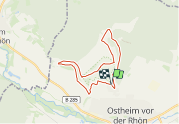
Trail On foot of 6.6 km to be discovered at Bavaria, Landkreis Rhön-Grabfeld, Ostheim v.d.Rhön. This trail is proposed by SityTrail - itinéraires balisés pédestres.
Description
Eine harmonische Runde, die ein breites Spektrum der landschaftlichen Schönheiten und kulturellen Besonderheiten zeigt
Website: https://www.wanderinstitut.de/premiumwege/bayern/extratour-ostheimer/
Positioning
Comments
Trails nearby
![Trail On foot Nordheim v.d.Rhön - Rhön-Rundweg Ostheim 5 - Photo](https://media.geolcdn.com/t/375/260/69671785-8cb7-4f78-9c66-a72d6aa62a06.jpeg&format=jpg&maxdim=2)
![On foot On foot](https://static1.geolcdn.com/sitytour/trail-icons/100.png)
On foot
![](/images/other/stat-length.png)
![](https://static1.geolcdn.com/siteimages/upload/files/16400158638029165_repeat_loop_refresh_sync_direction_icon.png)
![Trail On foot Willmars - Fladungen-Mellrichstadt - Photo](https://media.geolcdn.com/t/375/260/9f12fb27-f252-4356-aec9-a4f912d4df26.jpeg&format=jpg&maxdim=2)
![On foot On foot](https://static1.geolcdn.com/sitytour/trail-icons/100.png)
On foot
![](/images/other/stat-length.png)
![](https://static1.geolcdn.com/siteimages/upload/files/16400158638029165_repeat_loop_refresh_sync_direction_icon.png)
![Trail On foot Nordheim v.d.Rhön - Rhön-Rundweg](https://media.geolcdn.com/t/375/260/69671785-8cb7-4f78-9c66-a72d6aa62a06.jpeg&format=jpg&maxdim=2)
![On foot On foot](https://static1.geolcdn.com/sitytour/trail-icons/100.png)
On foot
![](/images/other/stat-length.png)
![](https://static1.geolcdn.com/siteimages/upload/files/16400158638029165_repeat_loop_refresh_sync_direction_icon.png)
![Trail On foot Nordheim v.d.Rhön - Rhön-Rundweg Nordheim 3 - Photo](https://media.geolcdn.com/t/375/260/69671785-8cb7-4f78-9c66-a72d6aa62a06.jpeg&format=jpg&maxdim=2)
![On foot On foot](https://static1.geolcdn.com/sitytour/trail-icons/100.png)
On foot
![](/images/other/stat-length.png)
![](https://static1.geolcdn.com/siteimages/upload/files/16400158638029165_repeat_loop_refresh_sync_direction_icon.png)
![Trail On foot Sondheim v.d.Rhön - Rhön-Rundweg Sondheim 2 - Photo](https://media.geolcdn.com/t/375/260/ext.jpg?maxdim=2&url=https%3A%2F%2Fstatic1.geolcdn.com%2Fsiteimages%2Fupload%2Ffiles%2F1545311037marcheuse_200dpi.jpg)
![On foot On foot](https://static1.geolcdn.com/sitytour/trail-icons/100.png)
On foot
![](/images/other/stat-length.png)
![](https://static1.geolcdn.com/siteimages/upload/files/16400158638029165_repeat_loop_refresh_sync_direction_icon.png)
![Trail On foot Sondheim v.d.Rhön - Rhön-Rundweg Sondheim 1 - Photo](https://media.geolcdn.com/t/375/260/ext.jpg?maxdim=2&url=https%3A%2F%2Fstatic1.geolcdn.com%2Fsiteimages%2Fupload%2Ffiles%2F1545311037marcheuse_200dpi.jpg)
![On foot On foot](https://static1.geolcdn.com/sitytour/trail-icons/100.png)
On foot
![](/images/other/stat-length.png)
![](https://static1.geolcdn.com/siteimages/upload/files/16400158638029165_repeat_loop_refresh_sync_direction_icon.png)