![](/images/other/stat-length.png)
![Trail On foot Unknown - Rheinsteig-Zuweg Freizeitpark Rheinaue - Photo](https://media.geolcdn.com/t/1900/400/0845bf48-a2ea-455b-9026-329e7c78e587.jpeg&format=pjpeg&maxdim=2)
Rheinsteig-Zuweg Freizeitpark Rheinaue
SityTrail - itinéraires balisés pédestres
Tous les sentiers balisés d’Europe GUIDE+
![Length](/images/other/stat-length.png)
Length
4.4 km
![Max alt](https://static1.geolcdn.com/siteimages/upload/files/1508320355ic_sort_altitude_max_24dp.png)
Max alt
68 m
![Uphill gradient](https://static1.geolcdn.com/siteimages/upload/files/1508320355ic_sort_den_pos_24dp.png)
Uphill gradient
21 m
![Km-Effort](/images/other/stat-length.png)
Km-Effort
4.7 km
![Min alt](https://static1.geolcdn.com/siteimages/upload/files/1508320355ic_sort_altitude_min_24dp.png)
Min alt
50 m
![Downhill gradient](https://static1.geolcdn.com/siteimages/upload/files/1508320355ic_sort_den_neg_24dp.png)
Downhill gradient
26 m
![Boucle](https://static1.geolcdn.com/siteimages/upload/files/16400158638029165_repeat_loop_refresh_sync_direction_icon.png)
Boucle
No
Signpost
Creation date :
2022-02-11 17:34:39.949
Updated on :
2022-02-11 17:34:39.949
![On foot](https://static1.geolcdn.com/sitytour/trail-icons/100.png)
1h03
Difficulty : Easy
![Scan this QR Code to open this trail in the SityTrail application](https://capi.geolives.com/qq0zvz2zws4bq2lad0pu/sitytour/trails/3098172/qr.png?size=200)
FREE GPS app for hiking
About
Trail On foot of 4.4 km to be discovered at North Rhine-Westphalia, Bonn, Unknown. This trail is proposed by SityTrail - itinéraires balisés pédestres.
Description
Trail created by Romantischer Rhein Tourismus GmbH.
Symbol: Stilisiertes weißes R auf gelbem Grund
Positioning
Country:
Germany
Region :
North Rhine-Westphalia
Department/Province :
Bonn
Municipality :
Unknown
Location:
Bad Godesberg
Start:(Dec)
Start:(UTM)
369058 ; 5618928 (32U) N.
Comments
Trails nearby
![Trail On foot Königswinter - Rheinsteig-Zuweg Heisterbacherrott - Photo](https://media.geolcdn.com/t/375/260/672a1fc0-8172-452e-abd5-b729cbfa39b9.jpeg&format=jpg&maxdim=2)
![On foot On foot](https://static1.geolcdn.com/sitytour/trail-icons/100.png)
Rheinsteig-Zuweg Heisterbacherrott
On foot
Easy
Königswinter,
North Rhine-Westphalia,
Rhein-Sieg-Kreis,
Germany
![](/images/other/stat-length.png)
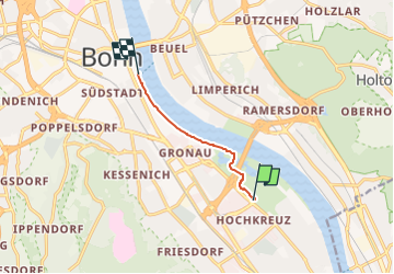
4.4 km | 6.6 km-effort
1h 29min
![](https://static1.geolcdn.com/siteimages/upload/files/16400158638029165_repeat_loop_refresh_sync_direction_icon.png)
No
![Trail On foot Unknown - [A17] Annaberger Hof Rundwanderweg - Photo](https://media.geolcdn.com/t/375/260/66a5293b-95d0-4ee1-b3eb-10d0f505deb1.jpeg&format=jpg&maxdim=2)
![On foot On foot](https://static1.geolcdn.com/sitytour/trail-icons/100.png)
[A17] Annaberger Hof Rundwanderweg
On foot
Easy
Unknown,
North Rhine-Westphalia,
Bonn,
Germany
![](/images/other/stat-length.png)
5.6 km | 6.3 km-effort
1h 26min
![](https://static1.geolcdn.com/siteimages/upload/files/16400158638029165_repeat_loop_refresh_sync_direction_icon.png)
Yes
![Trail On foot Unknown - [A12] Marienforst Rundwanderweg - Photo](https://media.geolcdn.com/t/375/260/09c3dfe3-391b-4308-a292-e2e47a5c25e6.jpeg&format=jpg&maxdim=2)
![On foot On foot](https://static1.geolcdn.com/sitytour/trail-icons/100.png)
[A12] Marienforst Rundwanderweg
On foot
Easy
Unknown,
North Rhine-Westphalia,
Bonn,
Germany
![](/images/other/stat-length.png)
4.3 km | 5.5 km-effort
1h 15min
![](https://static1.geolcdn.com/siteimages/upload/files/16400158638029165_repeat_loop_refresh_sync_direction_icon.png)
Yes
![Trail On foot Königswinter - [B] Beethoven Wanderweg - Photo](https://media.geolcdn.com/t/375/260/a0531be5-8927-4495-bf61-2ab0d601589a.jpeg&format=jpg&maxdim=2)
![On foot On foot](https://static1.geolcdn.com/sitytour/trail-icons/100.png)
[B] Beethoven Wanderweg
On foot
Medium
Königswinter,
North Rhine-Westphalia,
Rhein-Sieg-Kreis,
Germany
![](/images/other/stat-length.png)
15.3 km | 24 km-effort
5h 25min
![](https://static1.geolcdn.com/siteimages/upload/files/16400158638029165_repeat_loop_refresh_sync_direction_icon.png)
Yes
![Trail On foot Königswinter - KapellenSchleife 1 - Felder, Wiesen & Weiden - Photo](https://media.geolcdn.com/t/375/260/ext.jpg?maxdim=2&url=https%3A%2F%2Fstatic1.geolcdn.com%2Fsiteimages%2Fupload%2Ffiles%2F1545311037marcheuse_200dpi.jpg)
![On foot On foot](https://static1.geolcdn.com/sitytour/trail-icons/100.png)
KapellenSchleife 1 - Felder, Wiesen & Weiden
On foot
Easy
Königswinter,
North Rhine-Westphalia,
Rhein-Sieg-Kreis,
Germany
![](/images/other/stat-length.png)
13.4 km | 16.3 km-effort
3h 42min
![](https://static1.geolcdn.com/siteimages/upload/files/16400158638029165_repeat_loop_refresh_sync_direction_icon.png)
Yes
![Trail On foot Königswinter - Rheinsteig [Königswinter - Bad Honnef] - Photo](https://media.geolcdn.com/t/375/260/ext.jpg?maxdim=2&url=https%3A%2F%2Fstatic1.geolcdn.com%2Fsiteimages%2Fupload%2Ffiles%2F1545311037marcheuse_200dpi.jpg)
![On foot On foot](https://static1.geolcdn.com/sitytour/trail-icons/100.png)
Rheinsteig [Königswinter - Bad Honnef]
On foot
Medium
Königswinter,
North Rhine-Westphalia,
Rhein-Sieg-Kreis,
Germany
![](/images/other/stat-length.png)
14 km | 22 km-effort
4h 58min
![](https://static1.geolcdn.com/siteimages/upload/files/16400158638029165_repeat_loop_refresh_sync_direction_icon.png)
No
![Trail On foot Unknown - Rheinsteig [Bonn - Königswinter] - Photo](https://media.geolcdn.com/t/375/260/ext.jpg?maxdim=2&url=https%3A%2F%2Fstatic1.geolcdn.com%2Fsiteimages%2Fupload%2Ffiles%2F1545311037marcheuse_200dpi.jpg)
![On foot On foot](https://static1.geolcdn.com/sitytour/trail-icons/100.png)
Rheinsteig [Bonn - Königswinter]
On foot
Medium
Unknown,
North Rhine-Westphalia,
Bonn,
Germany
![](/images/other/stat-length.png)
22 km | 31 km-effort
7h 1min
![](https://static1.geolcdn.com/siteimages/upload/files/16400158638029165_repeat_loop_refresh_sync_direction_icon.png)
No
![Trail On foot Unknown - Rheinsteig (Siebengebirge) - Photo](https://media.geolcdn.com/t/375/260/ext.jpg?maxdim=2&url=https%3A%2F%2Fstatic1.geolcdn.com%2Fsiteimages%2Fupload%2Ffiles%2F1545311037marcheuse_200dpi.jpg)
![On foot On foot](https://static1.geolcdn.com/sitytour/trail-icons/100.png)
Rheinsteig (Siebengebirge)
On foot
Very difficult
Unknown,
North Rhine-Westphalia,
Bonn,
Germany
![](/images/other/stat-length.png)
54 km | 79 km-effort
17h 59min
![](https://static1.geolcdn.com/siteimages/upload/files/16400158638029165_repeat_loop_refresh_sync_direction_icon.png)
No
![Trail Mountain bike Unknown - Bonn 4 - Photo](https://media.geolcdn.com/t/375/260/ext.jpg?maxdim=2&url=https%3A%2F%2Fstatic1.geolcdn.com%2Fsiteimages%2Fupload%2Ffiles%2F1524743154velo.jpg)
![Mountain bike Mountain bike](https://static1.geolcdn.com/sitytour/trail-icons/202.png)
Bonn 4
Mountain bike
Easy
Unknown,
North Rhine-Westphalia,
Bonn,
Germany
![](/images/other/stat-length.png)
3.6 km | 4 km-effort
21min
![](https://static1.geolcdn.com/siteimages/upload/files/16400158638029165_repeat_loop_refresh_sync_direction_icon.png)
No