Trail On foot Taunusstein - Wingsbacher Rundwanderweg - Photo

Wingsbacher Rundwanderweg

Tous les sentiers balisés d’Europe PRO

© OpenStreetMap contributors
Length
Length
8.5 km
Max alt
Max alt
497 m
Uphill gradient
Uphill gradient
163 m
Km-Effort
Km-Effort  
10.7 km
Min alt
Min alt
389 m
Downhill gradient
Downhill gradient
163 m
Boucle
Boucle
Yes
Signpost
Signpost
Creation date :
2022-02-11 17:25:28.578
Updated on :
2022-02-11 17:25:28.578

(0 Reviews)

On foot
On foot
2h25
Difficulty : Easy

Scan this QR Code to open this trail in the SityTrail application

FREE GPS app for hiking

Logo SityTrail SityTrail

IGN / Geographical institutes

Download SityTrail from the App Store Download SityTrail from Google Play

Logo SityTrail SityTrail World

The world is yours!

Download SityTrail from the App Store Download SityTrail from Google Play Download SityTrail on Huawei AppGallery

About

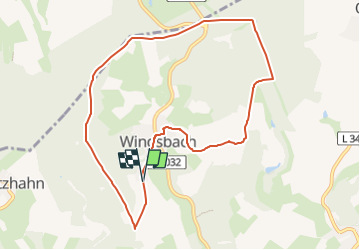
Trail On foot of 8.5 km to be discovered at Hesse, Rheingau-Taunus-Kreis, Taunusstein. This trail is proposed by SityTrail - itinéraires balisés pédestres.

Description

Trail created by Turn- und Gesangsverein Wingsbach 1913.

Symbol: oranger Kreis auf weißem Schild, darin blauer Text "Wingsbacher Rundwanderweg" und Vereins-Logo

Photos

Positioning

Country:
Germany
Region :
Hesse
Department/Province :
Rheingau-Taunus-Kreis
Municipality :
Taunusstein
Location:
Unknown
Start:(UTM)
439056 ; 5556999 (32U) N.

Trails nearby

Trail On foot Taunusstein - Rundwanderweg Keiler - Photo
On foot
PRO

On foot

Easy
Taunusstein, Hesse, Rheingau-Taunus-Kreis, Germany
4.7 km | 6 km-effort
1h 21min
No
Trail On foot Taunusstein - Rundwanderweg rote Flagge - Photo
On foot
PRO

On foot

Easy
Taunusstein, Hesse, Rheingau-Taunus-Kreis, Germany
4 km | 5.4 km-effort
1h 13min
Yes
Trail On foot Taunusstein - Schwarzer Hahn - Photo
On foot
PRO

On foot

Easy
Taunusstein, Hesse, Rheingau-Taunus-Kreis, Germany
7.2 km | 9.9 km-effort
2h 14min
Yes
Trail On foot Bad Schwalbach - Wanderweg 21 - Photo
On foot
PRO

On foot

Easy
Bad Schwalbach, Hesse, Rheingau-Taunus-Kreis, Germany
3.5 km | 5 km-effort
1h 8min
No
Trail On foot Taunusstein - Rundwanderweg rotes Quadrat - Photo
On foot
PRO

On foot

Easy
Taunusstein, Hesse, Rheingau-Taunus-Kreis, Germany
6.5 km | 9.2 km-effort
2h 5min
Yes
Trail On foot Taunusstein - Rundwanderweg gelbe Flagge - Photo
On foot
PRO

On foot

Easy
Taunusstein, Hesse, Rheingau-Taunus-Kreis, Germany
4 km | 5.8 km-effort
1h 19min
Yes
Trail On foot Taunusstein - Rundwanderweg gelbes Quadrat - Photo
On foot
PRO

On foot

Easy
Taunusstein, Hesse, Rheingau-Taunus-Kreis, Germany
4.3 km | 6.4 km-effort
1h 26min
Yes
Trail On foot Taunusstein - Rundwanderweg Forelle - Photo
On foot
PRO

On foot

Easy
Taunusstein, Hesse, Rheingau-Taunus-Kreis, Germany
6.4 km | 8.1 km-effort
1h 50min
Yes
Trail On foot Hohenstein - Rundwanderweg Rotmilan - Photo
On foot
PRO

On foot

Easy
Hohenstein, Hesse, Rheingau-Taunus-Kreis, Germany
3.2 km | 4.1 km-effort
56min
Yes


Close
My subscriptions