![](/images/other/stat-length.png)
![Trail On foot Großalmerode - Großalmerode, Rundweg 2 - Photo](https://media.geolcdn.com/t/1900/400/ext.pjpeg?maxdim=2&url=https%3A%2F%2Fmedia.geolcdn.com%2Ff%2F4365a2ae-62cb-4ee3-b193-b3566a377c49.jpeg)
Großalmerode, Rundweg 2
SityTrail - itinéraires balisés pédestres
Tous les sentiers balisés d’Europe PRO
![Length](/images/other/stat-length.png)
Length
6.2 km
![Max alt](https://static1.geolcdn.com/siteimages/upload/files/1508320355ic_sort_altitude_max_24dp.png)
Max alt
509 m
![Uphill gradient](https://static1.geolcdn.com/siteimages/upload/files/1508320355ic_sort_den_pos_24dp.png)
Uphill gradient
190 m
![Km-Effort](/images/other/stat-length.png)
Km-Effort
8.7 km
![Min alt](https://static1.geolcdn.com/siteimages/upload/files/1508320355ic_sort_altitude_min_24dp.png)
Min alt
341 m
![Downhill gradient](https://static1.geolcdn.com/siteimages/upload/files/1508320355ic_sort_den_neg_24dp.png)
Downhill gradient
193 m
![Boucle](https://static1.geolcdn.com/siteimages/upload/files/16400158638029165_repeat_loop_refresh_sync_direction_icon.png)
Boucle
Yes
Signpost
Creation date :
2022-02-11 17:14:29.007
Updated on :
2022-02-11 17:14:29.007
![On foot](https://static1.geolcdn.com/sitytour/trail-icons/100.png)
1h58
Difficulty : Easy
![Scan this QR Code to open this trail in the SityTrail application](https://capi.geolives.com/qq0zvz2zws4bq2lad0pu/sitytour/trails/3097539/qr.png?size=200)
FREE GPS app for hiking
About
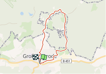
Trail On foot of 6.2 km to be discovered at Hesse, Werra-Meißner-Kreis, Großalmerode. This trail is proposed by SityTrail - itinéraires balisés pédestres.
Description
Trail created by Stadt Großalmerode.
Wanderweg wird von der Stadt Großalmerode nicht mehr gepflegt
Positioning
Country:
Germany
Region :
Hesse
Department/Province :
Werra-Meißner-Kreis
Municipality :
Großalmerode
Location:
Unknown
Start:(Dec)
Start:(UTM)
554793 ; 5678732 (32U) N.
Comments
Trails nearby
![Trail On foot Großalmerode - Großalmerode, Rundweg 21 - Photo](https://media.geolcdn.com/t/375/260/ext.jpg?maxdim=2&url=https%3A%2F%2Fmedia.geolcdn.com%2Ff%2Fd5090863-04b8-41fa-9929-2442b2f82f57.jpeg)
![On foot On foot](https://static1.geolcdn.com/sitytour/trail-icons/100.png)
Großalmerode, Rundweg 21
On foot
Easy
Großalmerode,
Hesse,
Werra-Meißner-Kreis,
Germany
![](/images/other/stat-length.png)
4.7 km | 6.5 km-effort
1h 28min
![](https://static1.geolcdn.com/siteimages/upload/files/16400158638029165_repeat_loop_refresh_sync_direction_icon.png)
Yes
![Trail On foot Gutsbezirk Kaufunger Wald - Großalmerode, Rundweg 18 - Photo](https://media.geolcdn.com/t/375/260/ext.jpg?maxdim=2&url=https%3A%2F%2Fmedia.geolcdn.com%2Ff%2Fa7004925-fa01-44e0-88fb-d4fe5055ba10.jpeg)
![On foot On foot](https://static1.geolcdn.com/sitytour/trail-icons/100.png)
Großalmerode, Rundweg 18
On foot
Easy
Gutsbezirk Kaufunger Wald,
Hesse,
Werra-Meißner-Kreis,
Germany
![](/images/other/stat-length.png)
8.9 km | 14.4 km-effort
3h 16min
![](https://static1.geolcdn.com/siteimages/upload/files/16400158638029165_repeat_loop_refresh_sync_direction_icon.png)
Yes
![Trail On foot Helsa - Kaufunger Wald, Rundweg 23 - Photo](https://media.geolcdn.com/t/375/260/ext.jpg?maxdim=2&url=https%3A%2F%2Fmedia.geolcdn.com%2Ff%2Fe706d2be-6dcb-45d5-9380-5104885f2f7f.jpeg)
![On foot On foot](https://static1.geolcdn.com/sitytour/trail-icons/100.png)
Kaufunger Wald, Rundweg 23
On foot
Easy
Helsa,
Hesse,
Landkreis Kassel,
Germany
![](/images/other/stat-length.png)
8.3 km | 11.6 km-effort
2h 38min
![](https://static1.geolcdn.com/siteimages/upload/files/16400158638029165_repeat_loop_refresh_sync_direction_icon.png)
Yes
![Trail On foot Gutsbezirk Kaufunger Wald - Rundweg Lichte Eiche - Photo](https://media.geolcdn.com/t/375/260/ext.jpg?maxdim=2&url=https%3A%2F%2Fmedia.geolcdn.com%2Ff%2F3ac3c368-0e25-46b5-9532-d254f296aa87.jpeg)
![On foot On foot](https://static1.geolcdn.com/sitytour/trail-icons/100.png)
Rundweg Lichte Eiche
On foot
Easy
Gutsbezirk Kaufunger Wald,
Hesse,
Werra-Meißner-Kreis,
Germany
![](/images/other/stat-length.png)
4.3 km | 5.9 km-effort
1h 20min
![](https://static1.geolcdn.com/siteimages/upload/files/16400158638029165_repeat_loop_refresh_sync_direction_icon.png)
Yes
![Trail On foot Witzenhausen - Bilsteinrundweg - Photo](https://media.geolcdn.com/t/375/260/ext.jpg?maxdim=2&url=https%3A%2F%2Fmedia.geolcdn.com%2Ff%2F3ac3c368-0e25-46b5-9532-d254f296aa87.jpeg)
![On foot On foot](https://static1.geolcdn.com/sitytour/trail-icons/100.png)
Bilsteinrundweg
On foot
Easy
Witzenhausen,
Hesse,
Werra-Meißner-Kreis,
Germany
![](/images/other/stat-length.png)
8.5 km | 13 km-effort
2h 57min
![](https://static1.geolcdn.com/siteimages/upload/files/16400158638029165_repeat_loop_refresh_sync_direction_icon.png)
Yes
![Trail On foot Großalmerode - Rundweg Heiligenberg - Dudenrode - Photo](https://media.geolcdn.com/t/375/260/ext.jpg?maxdim=2&url=https%3A%2F%2Fmedia.geolcdn.com%2Ff%2F8f0ba73b-89d7-4da8-9a04-806bb6f75cd7.jpeg)
![On foot On foot](https://static1.geolcdn.com/sitytour/trail-icons/100.png)
Rundweg Heiligenberg - Dudenrode
On foot
Easy
Großalmerode,
Hesse,
Werra-Meißner-Kreis,
Germany
![](/images/other/stat-length.png)
9.7 km | 14.4 km-effort
3h 16min
![](https://static1.geolcdn.com/siteimages/upload/files/16400158638029165_repeat_loop_refresh_sync_direction_icon.png)
Yes
![Trail On foot Hessisch Lichtenau - Rundweg um das Viehhaus - Photo](https://media.geolcdn.com/t/375/260/ext.jpg?maxdim=2&url=https%3A%2F%2Fmedia.geolcdn.com%2Ff%2Faf424e7d-7afb-4bf4-bd29-5482e587d472.jpeg)
![On foot On foot](https://static1.geolcdn.com/sitytour/trail-icons/100.png)
Rundweg um das Viehhaus
On foot
Easy
Hessisch Lichtenau,
Hesse,
Werra-Meißner-Kreis,
Germany
![](/images/other/stat-length.png)
3.3 km | 4.2 km-effort
57min
![](https://static1.geolcdn.com/siteimages/upload/files/16400158638029165_repeat_loop_refresh_sync_direction_icon.png)
Yes
![Trail On foot Großalmerode - Premiumweg Heiligenberg Rundweg - Photo](https://media.geolcdn.com/t/375/260/ext.jpg?maxdim=2&url=https%3A%2F%2Fmedia.geolcdn.com%2Ff%2F8f0ba73b-89d7-4da8-9a04-806bb6f75cd7.jpeg)
![On foot On foot](https://static1.geolcdn.com/sitytour/trail-icons/100.png)
Premiumweg Heiligenberg Rundweg
On foot
Easy
Großalmerode,
Hesse,
Werra-Meißner-Kreis,
Germany
![](/images/other/stat-length.png)
7 km | 9.9 km-effort
2h 14min
![](https://static1.geolcdn.com/siteimages/upload/files/16400158638029165_repeat_loop_refresh_sync_direction_icon.png)
Yes
![Trail On foot Gutsbezirk Kaufunger Wald - Kaufunger Wald, Rundweg 11 - Steinberg - Photo](https://media.geolcdn.com/t/375/260/ext.jpg?maxdim=2&url=https%3A%2F%2Fmedia.geolcdn.com%2Ff%2F8e5ec378-ed97-4358-a3a6-369eb3821eb2.jpeg)
![On foot On foot](https://static1.geolcdn.com/sitytour/trail-icons/100.png)
Kaufunger Wald, Rundweg 11 - Steinberg
On foot
Easy
Gutsbezirk Kaufunger Wald,
Hesse,
Werra-Meißner-Kreis,
Germany
![](/images/other/stat-length.png)
6.5 km | 8.9 km-effort
2h 1min
![](https://static1.geolcdn.com/siteimages/upload/files/16400158638029165_repeat_loop_refresh_sync_direction_icon.png)
Yes