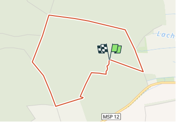
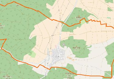
![](/images/other/stat-length.png)
![Trail On foot Steinfeld - Methusalem Wanderweg - Photo](https://media.geolcdn.com/t/1900/400/ext.pjpeg?maxdim=2&url=https%3A%2F%2Fstatic1.geolcdn.com%2Fsiteimages%2Fupload%2Ffiles%2F1545311037marcheuse_200dpi.jpg)
Methusalem Wanderweg
SityTrail - itinéraires balisés pédestres
Tous les sentiers balisés d’Europe GUIDE+
![Length](/images/other/stat-length.png)
![Max alt](https://static1.geolcdn.com/siteimages/upload/files/1508320355ic_sort_altitude_max_24dp.png)
![Uphill gradient](https://static1.geolcdn.com/siteimages/upload/files/1508320355ic_sort_den_pos_24dp.png)
![Km-Effort](/images/other/stat-length.png)
![Min alt](https://static1.geolcdn.com/siteimages/upload/files/1508320355ic_sort_altitude_min_24dp.png)
![Downhill gradient](https://static1.geolcdn.com/siteimages/upload/files/1508320355ic_sort_den_neg_24dp.png)
![Boucle](https://static1.geolcdn.com/siteimages/upload/files/16400158638029165_repeat_loop_refresh_sync_direction_icon.png)
![On foot](https://static1.geolcdn.com/sitytour/trail-icons/100.png)
1h13
Difficulty : Easy
![Scan this QR Code to open this trail in the SityTrail application](https://capi.geolives.com/qq0zvz2zws4bq2lad0pu/sitytour/trails/3097487/qr.png?size=200)
FREE GPS app for hiking
About
Trail On foot of 4.4 km to be discovered at Bavaria, Landkreis Main-Spessart, Steinfeld. This trail is proposed by SityTrail - itinéraires balisés pédestres.
Description
Trail created by Amt für Ernährung, Landwirtschaft und Forsten Karlstadt.
Website: http://www.steinfeld-msp.de/seite/de/gemeinde/0103:5317/-/Methusalem-Wanderweg.html
Positioning
Comments
Trails nearby
![Trail On foot Karlstadt - Ortswanderweg Karlstadt 3 - Photo](https://media.geolcdn.com/t/375/260/42180b53-2ecd-43ec-8e4d-6d51fff27480.jpeg&format=jpg&maxdim=2)
![On foot On foot](https://static1.geolcdn.com/sitytour/trail-icons/100.png)
On foot
![](/images/other/stat-length.png)
![](https://static1.geolcdn.com/siteimages/upload/files/16400158638029165_repeat_loop_refresh_sync_direction_icon.png)
![Trail On foot Lohr am Main - Ortswanderweg Lohr 8 - Photo](https://media.geolcdn.com/t/375/260/56c3d947-6313-4076-afff-abd22e91c2b6.jpeg&format=jpg&maxdim=2)
![On foot On foot](https://static1.geolcdn.com/sitytour/trail-icons/100.png)
On foot
![](/images/other/stat-length.png)
![](https://static1.geolcdn.com/siteimages/upload/files/16400158638029165_repeat_loop_refresh_sync_direction_icon.png)
![Trail On foot Lohr am Main - Ortswanderweg Lohr 2 - Photo](https://media.geolcdn.com/t/375/260/33758fce-e1c2-4209-9d69-d78091046e38.jpeg&format=jpg&maxdim=2)
![On foot On foot](https://static1.geolcdn.com/sitytour/trail-icons/100.png)
On foot
![](/images/other/stat-length.png)
![](https://static1.geolcdn.com/siteimages/upload/files/16400158638029165_repeat_loop_refresh_sync_direction_icon.png)
![Trail On foot Lohr am Main - Ortswanderweg Lohr 5 - Photo](https://media.geolcdn.com/t/375/260/1a6ced72-634a-4e07-839e-845900a0027b.jpeg&format=jpg&maxdim=2)
![On foot On foot](https://static1.geolcdn.com/sitytour/trail-icons/100.png)
On foot
![](/images/other/stat-length.png)
![](https://static1.geolcdn.com/siteimages/upload/files/16400158638029165_repeat_loop_refresh_sync_direction_icon.png)
![Trail On foot Lohr am Main - Methusalem Wanderweg Braune Route - Photo](https://media.geolcdn.com/t/375/260/cb724813-9af6-493f-90df-a3a39d32f3bf.jpeg&format=jpg&maxdim=2)
![On foot On foot](https://static1.geolcdn.com/sitytour/trail-icons/100.png)
On foot
![](/images/other/stat-length.png)
![](https://static1.geolcdn.com/siteimages/upload/files/16400158638029165_repeat_loop_refresh_sync_direction_icon.png)
![Trail On foot Steinfeld - Kulturweg Waldsassengau 2 - Photo](https://media.geolcdn.com/t/375/260/d1a7d55f-0430-4d47-b1fd-70d37ed38f7d.jpeg&format=jpg&maxdim=2)
![On foot On foot](https://static1.geolcdn.com/sitytour/trail-icons/100.png)
On foot
![](/images/other/stat-length.png)
![](https://static1.geolcdn.com/siteimages/upload/files/16400158638029165_repeat_loop_refresh_sync_direction_icon.png)
![Trail On foot Lohr am Main - Kulturweg Lohr 1 - Photo](https://media.geolcdn.com/t/375/260/1a6ced72-634a-4e07-839e-845900a0027b.jpeg&format=jpg&maxdim=2)
![On foot On foot](https://static1.geolcdn.com/sitytour/trail-icons/100.png)
On foot
![](/images/other/stat-length.png)
![](https://static1.geolcdn.com/siteimages/upload/files/16400158638029165_repeat_loop_refresh_sync_direction_icon.png)
![Trail On foot Steinfeld - Methusalem Wanderweg Blaue Route - Photo](https://media.geolcdn.com/t/375/260/831a1998-9adc-46c3-b0b4-98cd96c2acc8.jpeg&format=jpg&maxdim=2)
![On foot On foot](https://static1.geolcdn.com/sitytour/trail-icons/100.png)
On foot
![](/images/other/stat-length.png)
![](https://static1.geolcdn.com/siteimages/upload/files/16400158638029165_repeat_loop_refresh_sync_direction_icon.png)
![Trail On foot Steinfeld - Landwirtschaftlicher Rundweg Steinfeld - Photo](https://media.geolcdn.com/t/375/260/db41c6ff-0fbc-4994-905a-82642a4e0810.jpeg&format=jpg&maxdim=2)
![On foot On foot](https://static1.geolcdn.com/sitytour/trail-icons/100.png)
On foot
![](/images/other/stat-length.png)
![](https://static1.geolcdn.com/siteimages/upload/files/16400158638029165_repeat_loop_refresh_sync_direction_icon.png)