![](/images/other/stat-length.png)
![Trail On foot Stadecken-Elsheim - Selztal-Terroir-Route 4 - Photo](https://media.geolcdn.com/t/1900/400/ext.pjpeg?maxdim=2&url=https%3A%2F%2Fstatic1.geolcdn.com%2Fsiteimages%2Fupload%2Ffiles%2F1545311037marcheuse_200dpi.jpg)
Selztal-Terroir-Route 4
SityTrail - itinéraires balisés pédestres
Tous les sentiers balisés d’Europe GUIDE+
![Length](/images/other/stat-length.png)
Length
5.5 km
![Max alt](https://static1.geolcdn.com/siteimages/upload/files/1508320355ic_sort_altitude_max_24dp.png)
Max alt
221 m
![Uphill gradient](https://static1.geolcdn.com/siteimages/upload/files/1508320355ic_sort_den_pos_24dp.png)
Uphill gradient
124 m
![Km-Effort](/images/other/stat-length.png)
Km-Effort
7.1 km
![Min alt](https://static1.geolcdn.com/siteimages/upload/files/1508320355ic_sort_altitude_min_24dp.png)
Min alt
151 m
![Downhill gradient](https://static1.geolcdn.com/siteimages/upload/files/1508320355ic_sort_den_neg_24dp.png)
Downhill gradient
123 m
![Boucle](https://static1.geolcdn.com/siteimages/upload/files/16400158638029165_repeat_loop_refresh_sync_direction_icon.png)
Boucle
Yes
Signpost
Creation date :
2022-02-11 17:11:31.232
Updated on :
2022-02-11 17:11:31.232
![On foot](https://static1.geolcdn.com/sitytour/trail-icons/100.png)
1h37
Difficulty : Easy
![Scan this QR Code to open this trail in the SityTrail application](https://capi.geolives.com/qq0zvz2zws4bq2lad0pu/sitytour/trails/3097473/qr.png?size=200)
FREE GPS app for hiking
About
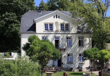
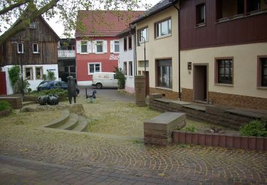
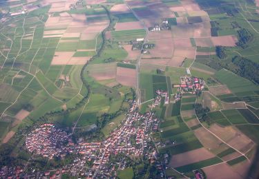
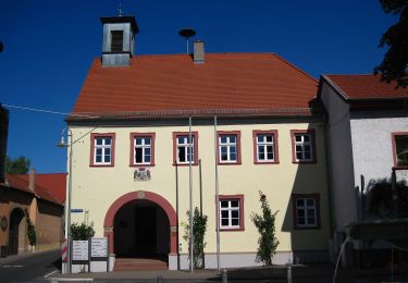
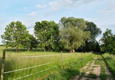
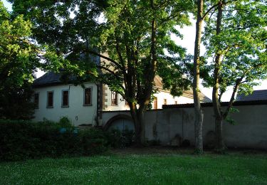
Trail On foot of 5.5 km to be discovered at Rhineland-Palatinate, Landkreis Mainz-Bingen, Stadecken-Elsheim. This trail is proposed by SityTrail - itinéraires balisés pédestres.
Description
Symbol: Einfach: Rechteck, oben blau, unten gelb. Design: Weinglas (?) vor blauem Himmel und gelbem Hügel
Positioning
Country:
Germany
Region :
Rhineland-Palatinate
Department/Province :
Landkreis Mainz-Bingen
Municipality :
Stadecken-Elsheim
Location:
Unknown
Start:(Dec)
Start:(UTM)
438288 ; 5529836 (32U) N.
Comments
Trails nearby
![Trail On foot Ingelheim am Rhein - Wanderweg Mainzer Berg - Photo](https://media.geolcdn.com/t/375/260/b2dea8bf-12a6-4c90-89f4-3306a67cdad5.jpeg&format=jpg&maxdim=2)
![On foot On foot](https://static1.geolcdn.com/sitytour/trail-icons/100.png)
Wanderweg Mainzer Berg
On foot
Easy
Ingelheim am Rhein,
Rhineland-Palatinate,
Landkreis Mainz-Bingen,
Germany
![](/images/other/stat-length.png)
3.6 km | 4.6 km-effort
1h 2min
![](https://static1.geolcdn.com/siteimages/upload/files/16400158638029165_repeat_loop_refresh_sync_direction_icon.png)
No
![Trail On foot Ingelheim am Rhein - Panoramaweg - Photo](https://media.geolcdn.com/t/375/260/b2dea8bf-12a6-4c90-89f4-3306a67cdad5.jpeg&format=jpg&maxdim=2)
![On foot On foot](https://static1.geolcdn.com/sitytour/trail-icons/100.png)
Panoramaweg
On foot
Easy
Ingelheim am Rhein,
Rhineland-Palatinate,
Landkreis Mainz-Bingen,
Germany
![](/images/other/stat-length.png)
3.4 km | 4.4 km-effort
59min
![](https://static1.geolcdn.com/siteimages/upload/files/16400158638029165_repeat_loop_refresh_sync_direction_icon.png)
No
![Trail On foot Nieder-Olm - Nordic Walking Nieder-Olm Nr. 6 - Photo](https://media.geolcdn.com/t/375/260/4f877ad0-4ef8-40ba-ad20-1c1b38adc4c7.jpeg&format=jpg&maxdim=2)
![On foot On foot](https://static1.geolcdn.com/sitytour/trail-icons/100.png)
Nordic Walking Nieder-Olm Nr. 6
On foot
Easy
Nieder-Olm,
Rhineland-Palatinate,
Landkreis Mainz-Bingen,
Germany
![](/images/other/stat-length.png)
8.5 km | 10.4 km-effort
2h 21min
![](https://static1.geolcdn.com/siteimages/upload/files/16400158638029165_repeat_loop_refresh_sync_direction_icon.png)
Yes
![Trail On foot Nieder-Olm - Nordic Walking Nieder-Olm Nr. 5 - Photo](https://media.geolcdn.com/t/375/260/63b79289-74ac-45f9-9b15-6214460ea3d0.jpeg&format=jpg&maxdim=2)
![On foot On foot](https://static1.geolcdn.com/sitytour/trail-icons/100.png)
Nordic Walking Nieder-Olm Nr. 5
On foot
Easy
Nieder-Olm,
Rhineland-Palatinate,
Landkreis Mainz-Bingen,
Germany
![](/images/other/stat-length.png)
5.7 km | 6.6 km-effort
1h 29min
![](https://static1.geolcdn.com/siteimages/upload/files/16400158638029165_repeat_loop_refresh_sync_direction_icon.png)
Yes
![Trail On foot Nieder-Olm - Nordic Walking Sörgenloch Nr. 4 - Photo](https://media.geolcdn.com/t/375/260/4f877ad0-4ef8-40ba-ad20-1c1b38adc4c7.jpeg&format=jpg&maxdim=2)
![On foot On foot](https://static1.geolcdn.com/sitytour/trail-icons/100.png)
Nordic Walking Sörgenloch Nr. 4
On foot
Easy
Nieder-Olm,
Rhineland-Palatinate,
Landkreis Mainz-Bingen,
Germany
![](/images/other/stat-length.png)
4.9 km | 5.6 km-effort
1h 15min
![](https://static1.geolcdn.com/siteimages/upload/files/16400158638029165_repeat_loop_refresh_sync_direction_icon.png)
Yes
![Trail On foot Jugenheim - Selztal-Terroir-Route 1 - Photo](https://media.geolcdn.com/t/375/260/d19552c1-b84b-4c48-a3b0-c00fbbeb49e4.jpeg&format=jpg&maxdim=2)
![On foot On foot](https://static1.geolcdn.com/sitytour/trail-icons/100.png)
Selztal-Terroir-Route 1
On foot
Easy
Jugenheim,
Rhineland-Palatinate,
Landkreis Mainz-Bingen,
Germany
![](/images/other/stat-length.png)
7.8 km | 9.7 km-effort
2h 12min
![](https://static1.geolcdn.com/siteimages/upload/files/16400158638029165_repeat_loop_refresh_sync_direction_icon.png)
Yes
![Trail On foot Schwabenheim an der Selz - Schwabenheim 5 Große Runde - Photo](https://media.geolcdn.com/t/375/260/ef27ae6b-9971-45ac-abe6-e3dd88cb5a20.jpeg&format=jpg&maxdim=2)
![On foot On foot](https://static1.geolcdn.com/sitytour/trail-icons/100.png)
Schwabenheim 5 Große Runde
On foot
Easy
Schwabenheim an der Selz,
Rhineland-Palatinate,
Landkreis Mainz-Bingen,
Germany
![](/images/other/stat-length.png)
13.7 km | 17.1 km-effort
3h 52min
![](https://static1.geolcdn.com/siteimages/upload/files/16400158638029165_repeat_loop_refresh_sync_direction_icon.png)
Yes
![Trail On foot Schwabenheim an der Selz - Schwabenheim 4 - Photo](https://media.geolcdn.com/t/375/260/968cecc3-0d63-49c6-921a-c573a818f576.jpeg&format=jpg&maxdim=2)
![On foot On foot](https://static1.geolcdn.com/sitytour/trail-icons/100.png)
Schwabenheim 4
On foot
Easy
Schwabenheim an der Selz,
Rhineland-Palatinate,
Landkreis Mainz-Bingen,
Germany
![](/images/other/stat-length.png)
5.4 km | 7.1 km-effort
1h 37min
![](https://static1.geolcdn.com/siteimages/upload/files/16400158638029165_repeat_loop_refresh_sync_direction_icon.png)
Yes
![Trail On foot Ingelheim am Rhein - Hiwweltour Westerberg - Photo](https://media.geolcdn.com/t/375/260/93020b02-356c-4019-a379-02bdac1b8a97.jpeg&format=jpg&maxdim=2)
![On foot On foot](https://static1.geolcdn.com/sitytour/trail-icons/100.png)
Hiwweltour Westerberg
On foot
Easy
Ingelheim am Rhein,
Rhineland-Palatinate,
Landkreis Mainz-Bingen,
Germany
![](/images/other/stat-length.png)
11.2 km | 13.8 km-effort
3h 8min
![](https://static1.geolcdn.com/siteimages/upload/files/16400158638029165_repeat_loop_refresh_sync_direction_icon.png)
Yes