


3.1 km | 4.3 km-effort
![Trail On foot Schlangen - Rundwanderweg 34 [Barnacken] - Photo](https://media.geolcdn.com/t/1900/400/83e8c965-88dc-4fa7-9331-4da86113c518.jpeg&format=pjpeg&maxdim=2)

Tous les sentiers balisés d’Europe GUIDE+


FREE GPS app for hiking
 SityTrail
IGN / Geographical institutes
SityTrail World
The world is yours!
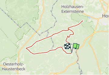
Trail On foot of 13.4 km to be discovered at North Rhine-Westphalia, Kreis Lippe, Schlangen. This trail is proposed by SityTrail - itinéraires balisés pédestres.
Trail created by Teutoburger Wald Verein.
Symbol: white text "34" on black background
![Trail On foot Schlangen - Rundwanderweg 34 [Barnacken] - Photo 1](https://media.geolcdn.com/t/2048/auto/70026ae3-f72e-4fe9-ae3b-23b628083807.jpeg&format=jpg&maxdim=0 "Trail On foot Schlangen - Rundwanderweg 34 [Barnacken] - Photo 1")
![Trail On foot Schlangen - Rundwanderweg 34 [Barnacken] - Photo 2](https://media.geolcdn.com/t/2048/auto/93f26a4a-18e5-4732-b693-f779d86ad49a.jpeg&format=jpg&maxdim=0 "Trail On foot Schlangen - Rundwanderweg 34 [Barnacken] - Photo 2")
![Trail On foot Schlangen - Rundwanderweg 34 [Barnacken] - Photo 3](https://media.geolcdn.com/t/2048/auto/8a58712e-6923-48bc-9281-c19da802abd6.jpeg&format=jpg&maxdim=0 "Trail On foot Schlangen - Rundwanderweg 34 [Barnacken] - Photo 3")
![Trail On foot Schlangen - Rundwanderweg 34 [Barnacken] - Photo 4](https://media.geolcdn.com/t/2048/auto/d2f054b9-7c78-4027-9ee2-f5c47f5505f6.jpeg&format=jpg&maxdim=0 "Trail On foot Schlangen - Rundwanderweg 34 [Barnacken] - Photo 4")
![Trail On foot Schlangen - Rundwanderweg 34 [Barnacken] - Photo 5](https://media.geolcdn.com/t/2048/auto/14fa8bbf-f043-4a49-bb28-f8b858f21250.jpeg&format=jpg&maxdim=0 "Trail On foot Schlangen - Rundwanderweg 34 [Barnacken] - Photo 5")
![Trail On foot Schlangen - Rundwanderweg 34 [Barnacken] - Photo 6](https://media.geolcdn.com/t/2048/auto/efa9b9a5-333a-4d8e-bf45-8a1299326977.jpeg&format=jpg&maxdim=0 "Trail On foot Schlangen - Rundwanderweg 34 [Barnacken] - Photo 6")
![Trail On foot Schlangen - Rundwanderweg 34 [Barnacken] - Photo 7](https://media.geolcdn.com/t/2048/auto/c87937e0-ec50-4d65-b546-a226fad8145f.jpeg&format=jpg&maxdim=0 "Trail On foot Schlangen - Rundwanderweg 34 [Barnacken] - Photo 7")
![Trail On foot Schlangen - Rundwanderweg 34 [Barnacken] - Photo 8](https://media.geolcdn.com/t/2048/auto/83e8c965-88dc-4fa7-9331-4da86113c518.jpeg&format=jpg&maxdim=0 "Trail On foot Schlangen - Rundwanderweg 34 [Barnacken] - Photo 8")
![Trail On foot Schlangen - Rundwanderweg 34 [Barnacken] - Photo 9](https://media.geolcdn.com/t/2048/auto/f0bbf5db-63c6-4694-9e2b-2396feccc2f2.jpeg&format=jpg&maxdim=0 "Trail On foot Schlangen - Rundwanderweg 34 [Barnacken] - Photo 9")
![Trail On foot Schlangen - Rundwanderweg 34 [Barnacken] - Photo 10](https://media.geolcdn.com/t/2048/auto/91d48bc9-f331-49ac-a59d-3bb65f372565.jpeg&format=jpg&maxdim=0 "Trail On foot Schlangen - Rundwanderweg 34 [Barnacken] - Photo 10")
On foot
On foot
On foot
On foot
![Trail On foot Horn-Bad Meinberg - Rundwanderweg A4 [Feldrom] - Photo](https://media.geolcdn.com/t/375/260/c3e2fda2-4a4b-4515-b251-ad31aeb36002.jpeg&format=jpg&maxdim=2)
On foot
On foot
![Trail On foot Steinheim - Rundwanderweg A1 [Grevenhagen] - Photo](https://media.geolcdn.com/t/375/260/202ac17e-dbff-44d1-b3d9-93eb341f466c.jpeg&format=jpg&maxdim=2)
On foot
![Trail On foot Detmold - Rundwanderweg A5 [Berlebeck] - Photo](https://media.geolcdn.com/t/375/260/09e96dc8-2a72-420e-af43-8a0b6d458613.jpeg&format=jpg&maxdim=2)
On foot
On foot