![](/images/other/stat-length.png)
![Trail Walking Hôpital-Camfrout - Troaon Tibidy et retour - Photo](https://media.geolcdn.com/t/1900/400/ext.pjpeg?maxdim=2&url=https%3A%2F%2Fstatic1.geolcdn.com%2Fsiteimages%2Fupload%2Ffiles%2F1553511878bg_sport_marche.png)
Troaon Tibidy et retour
denisrlb
User
![Length](/images/other/stat-length.png)
Length
5.2 km
![Max alt](https://static1.geolcdn.com/siteimages/upload/files/1508320355ic_sort_altitude_max_24dp.png)
Max alt
59 m
![Uphill gradient](https://static1.geolcdn.com/siteimages/upload/files/1508320355ic_sort_den_pos_24dp.png)
Uphill gradient
106 m
![Km-Effort](/images/other/stat-length.png)
Km-Effort
6.6 km
![Min alt](https://static1.geolcdn.com/siteimages/upload/files/1508320355ic_sort_altitude_min_24dp.png)
Min alt
1 m
![Downhill gradient](https://static1.geolcdn.com/siteimages/upload/files/1508320355ic_sort_den_neg_24dp.png)
Downhill gradient
101 m
![Boucle](https://static1.geolcdn.com/siteimages/upload/files/16400158638029165_repeat_loop_refresh_sync_direction_icon.png)
Boucle
Yes
Creation date :
2014-12-10 00:00:00.0
Updated on :
2014-12-10 00:00:00.0
![Walking](https://static1.geolcdn.com/sitytour/trail-icons/101.png)
1h03
Difficulty : Unknown
![Scan this QR Code to open this trail in the SityTrail application](https://capi.geolives.com/qq0zvz2zws4bq2lad0pu/sitytour/trails/309715/qr.png?size=200)
FREE GPS app for hiking
About
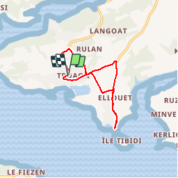
Trail Walking of 5.2 km to be discovered at Brittany, Finistère, Hôpital-Camfrout. This trail is proposed by denisrlb.
Description
Goarem Mhein, rue du Nerhu, rue de Vorlen, Tibidy et retour par route de Tibidy, rue du Nerhu, rue des Mimosas, route de Goasqueliou, Menhir et Goarem Mhein
Positioning
Country:
France
Region :
Brittany
Department/Province :
Finistère
Municipality :
Hôpital-Camfrout
Location:
Unknown
Start:(Dec)
Start:(UTM)
406510 ; 5351616 (30U) N.
Comments
Trails nearby
![Trail Walking Landévennec - Le tour de Landévennec Boucle 21 km - Photo](https://media.geolcdn.com/t/375/260/b342935f-f644-482b-a93d-00e8e9a2fff9.jpg&format=jpg&maxdim=2)
![Walking Walking](https://static1.geolcdn.com/sitytour/trail-icons/101.png)
Le tour de Landévennec Boucle 21 km
Walking
Very difficult
Landévennec,
Brittany,
Finistère,
France
![](/images/other/stat-length.png)
21 km | 28 km-effort
5h 10min
![](https://static1.geolcdn.com/siteimages/upload/files/16400158638029165_repeat_loop_refresh_sync_direction_icon.png)
Yes
![Trail Walking Landévennec - Landévennec - boucles locales et GR34 - 13.8km 250m 4h10 (35mn) - 2019 09 12 - Photo](https://media.geolcdn.com/t/375/260/ed0a847b-b2f3-4f8e-b6b5-8e6353637e62.jpg&format=jpg&maxdim=2)
![Walking Walking](https://static1.geolcdn.com/sitytour/trail-icons/101.png)
Landévennec - boucles locales et GR34 - 13.8km 250m 4h10 (35mn) - 2019 09 12
Walking
Easy
Landévennec,
Brittany,
Finistère,
France
![](/images/other/stat-length.png)
13.8 km | 17.2 km-effort
4h 10min
![](https://static1.geolcdn.com/siteimages/upload/files/16400158638029165_repeat_loop_refresh_sync_direction_icon.png)
Yes
![Trail Walking Landévennec - GR34 Rangoulic -- Lanvéoc - Photo](https://media.geolcdn.com/t/375/260/daf82018-5a85-440e-a8c3-587f360996b8.jpg&format=jpg&maxdim=2)
![Walking Walking](https://static1.geolcdn.com/sitytour/trail-icons/101.png)
GR34 Rangoulic -- Lanvéoc
Walking
Very difficult
Landévennec,
Brittany,
Finistère,
France
![](/images/other/stat-length.png)
25 km | 33 km-effort
7h 26min
![](https://static1.geolcdn.com/siteimages/upload/files/16400158638029165_repeat_loop_refresh_sync_direction_icon.png)
No
![Trail Walking Landévennec - LANDÉVENNEC - Photo](https://media.geolcdn.com/t/375/260/3aa9913a-4da7-4716-a24d-72b5f897ad92.jpg&format=jpg&maxdim=2)
![Walking Walking](https://static1.geolcdn.com/sitytour/trail-icons/101.png)
LANDÉVENNEC
Walking
Difficult
Landévennec,
Brittany,
Finistère,
France
![](/images/other/stat-length.png)
19.4 km | 25 km-effort
4h 41min
![](https://static1.geolcdn.com/siteimages/upload/files/16400158638029165_repeat_loop_refresh_sync_direction_icon.png)
No
![Trail On foot Logonna-Daoulas - Sentier Côtier - Photo](https://media.geolcdn.com/t/375/260/5cd226de-ab15-485c-ad56-76bdfb355d74.jpeg&format=jpg&maxdim=2)
![On foot On foot](https://static1.geolcdn.com/sitytour/trail-icons/100.png)
Sentier Côtier
On foot
Easy
Logonna-Daoulas,
Brittany,
Finistère,
France
![](/images/other/stat-length.png)
9.7 km | 11.6 km-effort
2h 38min
![](https://static1.geolcdn.com/siteimages/upload/files/16400158638029165_repeat_loop_refresh_sync_direction_icon.png)
No
![Trail Walking Hôpital-Camfrout - L'Hôpital-Camfrout. vers moulin mer - Photo](https://media.geolcdn.com/t/375/260/24106eec-ae1c-4897-9322-9b7dd7476d0a.jpg&format=jpg&maxdim=2)
![Walking Walking](https://static1.geolcdn.com/sitytour/trail-icons/101.png)
L'Hôpital-Camfrout. vers moulin mer
Walking
Difficult
Hôpital-Camfrout,
Brittany,
Finistère,
France
![](/images/other/stat-length.png)
11.3 km | 13.2 km-effort
2h 2min
![](https://static1.geolcdn.com/siteimages/upload/files/16400158638029165_repeat_loop_refresh_sync_direction_icon.png)
Yes
![Trail Walking Logonna-Daoulas - Circuit de l'anse de Pen Foul. Logona. 06/07/20 - Photo](https://media.geolcdn.com/t/375/260/1dda4c52-fb47-4e06-aa03-a8ba7d97f79b.jpg&format=jpg&maxdim=2)
![Walking Walking](https://static1.geolcdn.com/sitytour/trail-icons/101.png)
Circuit de l'anse de Pen Foul. Logona. 06/07/20
Walking
Very easy
(1)
Logonna-Daoulas,
Brittany,
Finistère,
France
![](/images/other/stat-length.png)
5.6 km | 7 km-effort
1h 33min
![](https://static1.geolcdn.com/siteimages/upload/files/16400158638029165_repeat_loop_refresh_sync_direction_icon.png)
No
![Trail Walking Argol - Térénez - Kerivin - Photo](https://media.geolcdn.com/t/375/260/ext.jpg?maxdim=2&url=https%3A%2F%2Fstatic1.geolcdn.com%2Fsiteimages%2Fupload%2Ffiles%2F1553511878bg_sport_marche.png)
![Walking Walking](https://static1.geolcdn.com/sitytour/trail-icons/101.png)
Térénez - Kerivin
Walking
Very easy
(1)
Argol,
Brittany,
Finistère,
France
![](/images/other/stat-length.png)
11.9 km | 15 km-effort
3h 15min
![](https://static1.geolcdn.com/siteimages/upload/files/16400158638029165_repeat_loop_refresh_sync_direction_icon.png)
Yes
![Trail Walking Landévennec - Presqu'île Crozon - Day 02 - Photo](https://media.geolcdn.com/t/375/260/ext.jpg?maxdim=2&url=https%3A%2F%2Fservices.sitytrail.com%2FGeolivesWS%2FDownloadMedia.ashx%3FTrailID%3D615620%26Media%3D20160816153425.jpg)
![Walking Walking](https://static1.geolcdn.com/sitytour/trail-icons/101.png)
Presqu'île Crozon - Day 02
Walking
Medium
Landévennec,
Brittany,
Finistère,
France
![](/images/other/stat-length.png)
23 km | 30 km-effort
5h 54min
![](https://static1.geolcdn.com/siteimages/upload/files/16400158638029165_repeat_loop_refresh_sync_direction_icon.png)
No