![](/images/other/stat-length.png)
![Trail On foot Altena - Rundweg um Dahle - Photo](https://media.geolcdn.com/t/1900/400/d5caa100-b7f3-4512-b05d-351c0594e2d3.jpeg&format=pjpeg&maxdim=2)
Rundweg um Dahle
SityTrail - itinéraires balisés pédestres
Tous les sentiers balisés d’Europe GUIDE+
![Length](/images/other/stat-length.png)
Length
14.1 km
![Max alt](https://static1.geolcdn.com/siteimages/upload/files/1508320355ic_sort_altitude_max_24dp.png)
Max alt
519 m
![Uphill gradient](https://static1.geolcdn.com/siteimages/upload/files/1508320355ic_sort_den_pos_24dp.png)
Uphill gradient
399 m
![Km-Effort](/images/other/stat-length.png)
Km-Effort
19.4 km
![Min alt](https://static1.geolcdn.com/siteimages/upload/files/1508320355ic_sort_altitude_min_24dp.png)
Min alt
329 m
![Downhill gradient](https://static1.geolcdn.com/siteimages/upload/files/1508320355ic_sort_den_neg_24dp.png)
Downhill gradient
401 m
![Boucle](https://static1.geolcdn.com/siteimages/upload/files/16400158638029165_repeat_loop_refresh_sync_direction_icon.png)
Boucle
Yes
Signpost
Creation date :
2022-02-11 16:52:04.309
Updated on :
2022-02-11 16:52:04.309
![On foot](https://static1.geolcdn.com/sitytour/trail-icons/100.png)
4h24
Difficulty : Easy
![Scan this QR Code to open this trail in the SityTrail application](https://capi.geolives.com/qq0zvz2zws4bq2lad0pu/sitytour/trails/3096988/qr.png?size=200)
FREE GPS app for hiking
About
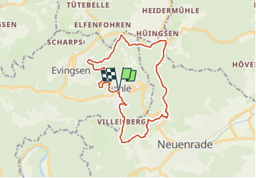
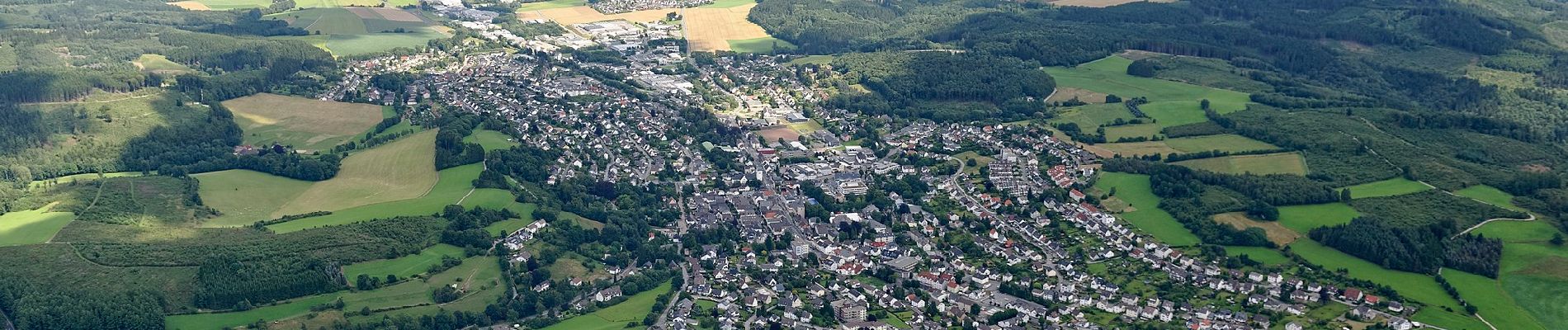
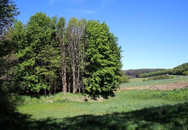
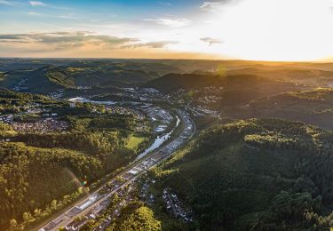
Trail On foot of 14.1 km to be discovered at North Rhine-Westphalia, Märkischer Kreis, Altena. This trail is proposed by SityTrail - itinéraires balisés pédestres.
Description
Trail created by Sauerländischer Gebirgsverein (SGV).
Symbol: Weißes D in weißem Kreis auf schwarzem Grund
Positioning
Country:
Germany
Region :
North Rhine-Westphalia
Department/Province :
Märkischer Kreis
Municipality :
Altena
Location:
Unknown
Start:(Dec)
Start:(UTM)
412935 ; 5683848 (32U) N.
Comments
Trails nearby
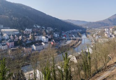
![Trail On foot Altena - [A1] Am Schwarzenstein - Photo](https://media.geolcdn.com/t/375/260/4104e1fa-73a0-495c-b42d-1a5934faf322.jpeg&format=jpg&maxdim=2)
![On foot On foot](https://static1.geolcdn.com/sitytour/trail-icons/100.png)
[A1] Am Schwarzenstein
On foot
Easy
Altena,
North Rhine-Westphalia,
Märkischer Kreis,
Germany
![](/images/other/stat-length.png)
3.8 km | 5.8 km-effort
1h 19min
![](https://static1.geolcdn.com/siteimages/upload/files/16400158638029165_repeat_loop_refresh_sync_direction_icon.png)
Yes
![Trail On foot Neuenrade - Neuenrader Rundweg - Photo](https://media.geolcdn.com/t/375/260/dafcf1a3-0462-4665-b687-17e40ebf945b.jpeg&format=jpg&maxdim=2)
![On foot On foot](https://static1.geolcdn.com/sitytour/trail-icons/100.png)
Neuenrader Rundweg
On foot
Easy
Neuenrade,
North Rhine-Westphalia,
Märkischer Kreis,
Germany
![](/images/other/stat-length.png)
12.6 km | 17.5 km-effort
3h 59min
![](https://static1.geolcdn.com/siteimages/upload/files/16400158638029165_repeat_loop_refresh_sync_direction_icon.png)
No
![Trail On foot Iserlohn - Atenaer Rundweg - Photo](https://media.geolcdn.com/t/375/260/ac541118-8fb3-4eda-991b-ceab80b85a33.jpeg&format=jpg&maxdim=2)
![On foot On foot](https://static1.geolcdn.com/sitytour/trail-icons/100.png)
Atenaer Rundweg
On foot
Easy
Iserlohn,
North Rhine-Westphalia,
Märkischer Kreis,
Germany
![](/images/other/stat-length.png)
6.7 km | 8.5 km-effort
1h 55min
![](https://static1.geolcdn.com/siteimages/upload/files/16400158638029165_repeat_loop_refresh_sync_direction_icon.png)
No
![Trail On foot Balve - Balve Rundweg A0 - Photo](https://media.geolcdn.com/t/375/260/e2bdbe04-a8d4-4bd6-a660-9174686fa154.jpeg&format=jpg&maxdim=2)
![On foot On foot](https://static1.geolcdn.com/sitytour/trail-icons/100.png)
Balve Rundweg A0
On foot
Easy
Balve,
North Rhine-Westphalia,
Märkischer Kreis,
Germany
![](/images/other/stat-length.png)
9.8 km | 13.4 km-effort
3h 2min
![](https://static1.geolcdn.com/siteimages/upload/files/16400158638029165_repeat_loop_refresh_sync_direction_icon.png)
Yes
![Trail On foot Hemer - Rundweg Hemer - Photo](https://media.geolcdn.com/t/375/260/14a71854-322f-4ad3-8606-046ac83a44c8.jpeg&format=jpg&maxdim=2)
![On foot On foot](https://static1.geolcdn.com/sitytour/trail-icons/100.png)
Rundweg Hemer
On foot
Very difficult
Hemer,
North Rhine-Westphalia,
Märkischer Kreis,
Germany
![](/images/other/stat-length.png)
45 km | 61 km-effort
13h 53min
![](https://static1.geolcdn.com/siteimages/upload/files/16400158638029165_repeat_loop_refresh_sync_direction_icon.png)
Yes
![Trail On foot Balve - Garbeck Rundweg A5 - Photo](https://media.geolcdn.com/t/375/260/56fe0bbb-9be6-49bb-94b4-a943b875479a.jpeg&format=jpg&maxdim=2)
![On foot On foot](https://static1.geolcdn.com/sitytour/trail-icons/100.png)
Garbeck Rundweg A5
On foot
Easy
Balve,
North Rhine-Westphalia,
Märkischer Kreis,
Germany
![](/images/other/stat-length.png)
4.6 km | 6.7 km-effort
1h 30min
![](https://static1.geolcdn.com/siteimages/upload/files/16400158638029165_repeat_loop_refresh_sync_direction_icon.png)
No
![Trail On foot Neuenrade - Werdohler Rundweg - Photo](https://media.geolcdn.com/t/375/260/8fef0efa-58c8-4f1e-b8b1-428cbb3fe6a6.jpeg&format=jpg&maxdim=2)
![On foot On foot](https://static1.geolcdn.com/sitytour/trail-icons/100.png)
Werdohler Rundweg
On foot
Easy
Neuenrade,
North Rhine-Westphalia,
Märkischer Kreis,
Germany
![](/images/other/stat-length.png)
4 km | 5.3 km-effort
1h 12min
![](https://static1.geolcdn.com/siteimages/upload/files/16400158638029165_repeat_loop_refresh_sync_direction_icon.png)
No
![Trail On foot Altena - Evingsener Rundweg - Photo](https://media.geolcdn.com/t/375/260/ext.jpg?maxdim=2&url=https%3A%2F%2Fstatic1.geolcdn.com%2Fsiteimages%2Fupload%2Ffiles%2F1545311037marcheuse_200dpi.jpg)
![On foot On foot](https://static1.geolcdn.com/sitytour/trail-icons/100.png)
Evingsener Rundweg
On foot
Easy
Altena,
North Rhine-Westphalia,
Märkischer Kreis,
Germany
![](/images/other/stat-length.png)
10.1 km | 14.6 km-effort
3h 18min
![](https://static1.geolcdn.com/siteimages/upload/files/16400158638029165_repeat_loop_refresh_sync_direction_icon.png)
Yes
![Trail On foot Balve - Garbecker Rundweg - Photo](https://media.geolcdn.com/t/375/260/ext.jpg?maxdim=2&url=https%3A%2F%2Fstatic1.geolcdn.com%2Fsiteimages%2Fupload%2Ffiles%2F1545311037marcheuse_200dpi.jpg)
![On foot On foot](https://static1.geolcdn.com/sitytour/trail-icons/100.png)
Garbecker Rundweg
On foot
Easy
Balve,
North Rhine-Westphalia,
Märkischer Kreis,
Germany
![](/images/other/stat-length.png)
5.5 km | 6.8 km-effort
1h 32min
![](https://static1.geolcdn.com/siteimages/upload/files/16400158638029165_repeat_loop_refresh_sync_direction_icon.png)
No