![](/images/other/stat-length.png)
![Trail On foot Bad Mergentheim - Liebliches Taubertal 15 - Photo](https://media.geolcdn.com/t/1900/400/489bae20-f786-4b9c-89f6-a8cea704cf53.jpeg&format=pjpeg&maxdim=2)
Liebliches Taubertal 15
SityTrail - itinéraires balisés pédestres
Tous les sentiers balisés d’Europe GUIDE+
![Length](/images/other/stat-length.png)
Length
5.7 km
![Max alt](https://static1.geolcdn.com/siteimages/upload/files/1508320355ic_sort_altitude_max_24dp.png)
Max alt
374 m
![Uphill gradient](https://static1.geolcdn.com/siteimages/upload/files/1508320355ic_sort_den_pos_24dp.png)
Uphill gradient
93 m
![Km-Effort](/images/other/stat-length.png)
Km-Effort
7.2 km
![Min alt](https://static1.geolcdn.com/siteimages/upload/files/1508320355ic_sort_altitude_min_24dp.png)
Min alt
215 m
![Downhill gradient](https://static1.geolcdn.com/siteimages/upload/files/1508320355ic_sort_den_neg_24dp.png)
Downhill gradient
182 m
![Boucle](https://static1.geolcdn.com/siteimages/upload/files/16400158638029165_repeat_loop_refresh_sync_direction_icon.png)
Boucle
No
Signpost
Creation date :
2022-02-11 16:50:09.835
Updated on :
2022-02-11 16:50:09.835
![On foot](https://static1.geolcdn.com/sitytour/trail-icons/100.png)
1h38
Difficulty : Easy
![Scan this QR Code to open this trail in the SityTrail application](https://capi.geolives.com/qq0zvz2zws4bq2lad0pu/sitytour/trails/3096935/qr.png?size=200)
FREE GPS app for hiking
About
Trail On foot of 5.7 km to be discovered at Baden-Württemberg, Main-Tauber-Kreis, Bad Mergentheim. This trail is proposed by SityTrail - itinéraires balisés pédestres.
Description
Symbol: blaues Schild mit weißer Schrift, in der Mitte durch eine weiße Linie getrennt. Obehalb "LT", darunter "15"
Positioning
Country:
Germany
Region :
Baden-Württemberg
Department/Province :
Main-Tauber-Kreis
Municipality :
Bad Mergentheim
Location:
Unknown
Start:(Dec)
Start:(UTM)
552303 ; 5482991 (32U) N.
Comments
Trails nearby
![Trail On foot Bad Mergentheim - Wanderweg 14 - Photo](https://media.geolcdn.com/t/375/260/189d946a-134c-4286-80bb-1ab9fdf9a976.jpeg&format=jpg&maxdim=2)
![On foot On foot](https://static1.geolcdn.com/sitytour/trail-icons/100.png)
Wanderweg 14
On foot
Easy
Bad Mergentheim,
Baden-Württemberg,
Main-Tauber-Kreis,
Germany
![](/images/other/stat-length.png)
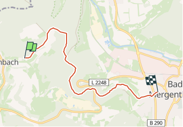
3.7 km | 4.5 km-effort
1h 1min
![](https://static1.geolcdn.com/siteimages/upload/files/16400158638029165_repeat_loop_refresh_sync_direction_icon.png)
No
![Trail On foot Bad Mergentheim - Wanderweg 27 - Photo](https://media.geolcdn.com/t/375/260/c5f9c2b6-27f8-4ab1-b862-9d0027afbd91.jpeg&format=jpg&maxdim=2)
![On foot On foot](https://static1.geolcdn.com/sitytour/trail-icons/100.png)
Wanderweg 27
On foot
Easy
Bad Mergentheim,
Baden-Württemberg,
Main-Tauber-Kreis,
Germany
![](/images/other/stat-length.png)
3.3 km | 4.7 km-effort
1h 4min
![](https://static1.geolcdn.com/siteimages/upload/files/16400158638029165_repeat_loop_refresh_sync_direction_icon.png)
No
![Trail On foot Bad Mergentheim - Waldlehrpfad - Photo](https://media.geolcdn.com/t/375/260/ext.jpg?maxdim=2&url=https%3A%2F%2Fstatic1.geolcdn.com%2Fsiteimages%2Fupload%2Ffiles%2F1545311037marcheuse_200dpi.jpg)
![On foot On foot](https://static1.geolcdn.com/sitytour/trail-icons/100.png)
Waldlehrpfad
On foot
Easy
Bad Mergentheim,
Baden-Württemberg,
Main-Tauber-Kreis,
Germany
![](/images/other/stat-length.png)
3.5 km | 4.8 km-effort
1h 4min
![](https://static1.geolcdn.com/siteimages/upload/files/16400158638029165_repeat_loop_refresh_sync_direction_icon.png)
Yes