Trail On foot Pleisweiler-Oberhofen - Kapellen-Pilgerweg - Photo

Tous les sentiers balisés d’Europe GUIDE+

© OpenStreetMap contributors
Length
Length
72 km
Max alt
Max alt
530 m
Uphill gradient
Uphill gradient
2256 m
Km-Effort
Km-Effort  
102 km
Min alt
Min alt
177 m
Downhill gradient
Downhill gradient
2268 m
Boucle
Boucle
Yes
Signpost
Signpost
Creation date :
2022-02-11 16:46:12.614
Updated on :
2022-02-11 16:46:12.614

(0 Reviews)

On foot
On foot
23h17
Difficulty : Very difficult

Scan this QR Code to open this trail in the SityTrail application

FREE GPS app for hiking

Logo SityTrail SityTrail

IGN / Geographical institutes

Download SityTrail from the App Store Download SityTrail from Google Play

Logo SityTrail SityTrail World

The world is yours!

Download SityTrail from the App Store Download SityTrail from Google Play Download SityTrail on Huawei AppGallery

About

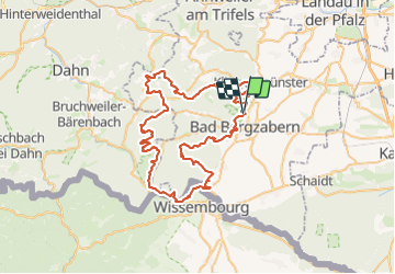
Trail On foot of 72 km to be discovered at Rhineland-Palatinate, Landkreis Südliche Weinstraße, Pleisweiler-Oberhofen. This trail is proposed by SityTrail - itinéraires balisés pédestres.

Description

Trail created by Tourismusverein Südliche Weinstrasse Bad Bergzabern.

Pleisweiler: Lücke in Natur noch nicht markiert (Mai 2016)

Symbol: weißes Kreuz in lila Raute

Elevation profile

Photos

Positioning

Country:
Germany
Region :
Rhineland-Palatinate
Department/Province :
Landkreis Südliche Weinstraße
Municipality :
Pleisweiler-Oberhofen
Location:
Unknown
Start:(UTM)
426837 ; 5440674 (32U) N.

Trails nearby

Trail On foot Bad Bergzabern - Rund um den Steinkopf, Blankenborn - Photo
On foot
GUIDE+

On foot

Easy
Bad Bergzabern, Rhineland-Palatinate, Landkreis Südliche Weinstraße, Germany
6 km | 8.1 km-effort
1h 51min
Yes
Trail On foot Gleiszellen-Gleishorbach - Karlsplatzweg, Klingenmüster - Photo
On foot
GUIDE+

On foot

Easy
Gleiszellen-Gleishorbach, Rhineland-Palatinate, Landkreis Südliche Weinstraße, Germany
6.3 km | 9.5 km-effort
2h 9min
Yes
Trail On foot Gleiszellen-Gleishorbach - Gleiszellen: Sauhausbrunnen-Weg - Photo
On foot
GUIDE+

On foot

Easy
Gleiszellen-Gleishorbach, Rhineland-Palatinate, Landkreis Südliche Weinstraße, Germany
11.1 km | 15.4 km-effort
3h 30min
Yes
Trail On foot Gleiszellen-Gleishorbach - Gleiszellen: Mischwald-Wanderweg - Photo
On foot
GUIDE+

On foot

Easy
Gleiszellen-Gleishorbach, Rhineland-Palatinate, Landkreis Südliche Weinstraße, Germany
10 km | 14.1 km-effort
3h 11min
Yes
Trail On foot Bad Bergzabern - Bad Bergzabern: Tabernae-Montanus-Weg - Photo
On foot
GUIDE+

On foot

Easy
Bad Bergzabern, Rhineland-Palatinate, Landkreis Südliche Weinstraße, Germany
10.7 km | 15.9 km-effort
3h 36min
Yes
Trail On foot Dörrenbach - Weg der Aussichten, Dörrenbach - Photo
On foot
GUIDE+

On foot

Easy
Dörrenbach, Rhineland-Palatinate, Landkreis Südliche Weinstraße, Germany
5.3 km | 7.9 km-effort
1h 47min
No
Trail On foot Oberotterbach - Weg der Geschichte, Oberotterbach - Photo
On foot
GUIDE+

On foot

Easy
Oberotterbach, Rhineland-Palatinate, Landkreis Südliche Weinstraße, Germany
11.4 km | 15.6 km-effort
3h 32min
Yes
Trail On foot Oberotterbach - Dornröschen Rundwanderweg, Dörrenbach - Photo
On foot
GUIDE+

On foot

Easy
Oberotterbach, Rhineland-Palatinate, Landkreis Südliche Weinstraße, Germany
8.9 km | 13 km-effort
2h 56min
Yes
Trail On foot Münchweiler am Klingbach - Quellenweg Klingenmünster - Photo
On foot
GUIDE+

On foot

Easy
Münchweiler am Klingbach, Rhineland-Palatinate, Landkreis Südliche Weinstraße, Germany
5.5 km | 8 km-effort
1h 49min
Yes


Close
My subscriptions