![](/images/other/stat-length.png)
![Trail On foot Wallerfangen - Grenzblickweg - Photo](https://media.geolcdn.com/t/1900/400/d871565d-7bd5-4de8-9b5a-aeebe8ecae11.jpeg&format=pjpeg&maxdim=2)
Grenzblickweg
SityTrail - itinéraires balisés pédestres
Tous les sentiers balisés d’Europe GUIDE+
![Length](/images/other/stat-length.png)
Length
13.5 km
![Max alt](https://static1.geolcdn.com/siteimages/upload/files/1508320355ic_sort_altitude_max_24dp.png)
Max alt
335 m
![Uphill gradient](https://static1.geolcdn.com/siteimages/upload/files/1508320355ic_sort_den_pos_24dp.png)
Uphill gradient
275 m
![Km-Effort](/images/other/stat-length.png)
Km-Effort
17.2 km
![Min alt](https://static1.geolcdn.com/siteimages/upload/files/1508320355ic_sort_altitude_min_24dp.png)
Min alt
199 m
![Downhill gradient](https://static1.geolcdn.com/siteimages/upload/files/1508320355ic_sort_den_neg_24dp.png)
Downhill gradient
273 m
![Boucle](https://static1.geolcdn.com/siteimages/upload/files/16400158638029165_repeat_loop_refresh_sync_direction_icon.png)
Boucle
Yes
Signpost
Creation date :
2022-02-11 16:45:11.223
Updated on :
2022-02-11 16:45:11.223
![On foot](https://static1.geolcdn.com/sitytour/trail-icons/100.png)
3h54
Difficulty : Easy
![Scan this QR Code to open this trail in the SityTrail application](https://capi.geolives.com/qq0zvz2zws4bq2lad0pu/sitytour/trails/3096781/qr.png?size=200)
FREE GPS app for hiking
About
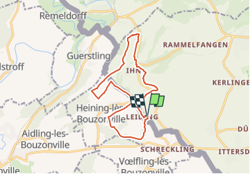
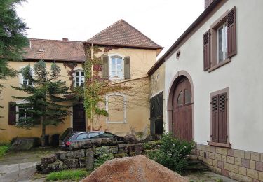
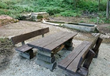
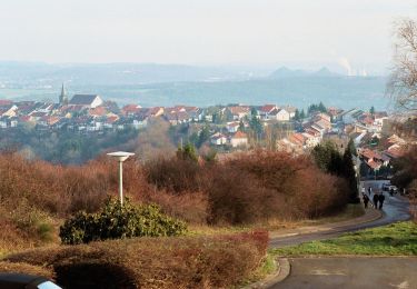
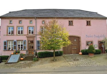
Trail On foot of 13.5 km to be discovered at Saarland, Landkreis Saarlouis, Wallerfangen. This trail is proposed by SityTrail - itinéraires balisés pédestres.
Description
Symbol: Traumschleifenlogo u. "Grenzblickweg"
Positioning
Country:
Germany
Region :
Saarland
Department/Province :
Landkreis Saarlouis
Municipality :
Wallerfangen
Location:
Leidingen
Start:(Dec)
Start:(UTM)
326331 ; 5464435 (32U) N.
Comments
Trails nearby
![Trail On foot Wallerfangen - Vauban-Steig - Photo](https://media.geolcdn.com/t/375/260/3f89e64e-5547-4f6d-9017-d0a7fdadca25.jpeg&format=jpg&maxdim=2)
![On foot On foot](https://static1.geolcdn.com/sitytour/trail-icons/100.png)
Vauban-Steig
On foot
Easy
Wallerfangen,
Saarland,
Landkreis Saarlouis,
Germany
![](/images/other/stat-length.png)
12.1 km | 16 km-effort
3h 38min
![](https://static1.geolcdn.com/siteimages/upload/files/16400158638029165_repeat_loop_refresh_sync_direction_icon.png)
Yes
![Trail On foot Wallerfangen - Der Gisinger - Photo](https://media.geolcdn.com/t/375/260/7c22b417-8b5a-4f26-aaa3-45405225b73f.jpeg&format=jpg&maxdim=2)
![On foot On foot](https://static1.geolcdn.com/sitytour/trail-icons/100.png)
Der Gisinger
On foot
Easy
Wallerfangen,
Saarland,
Landkreis Saarlouis,
Germany
![](/images/other/stat-length.png)
10.8 km | 14.1 km-effort
3h 11min
![](https://static1.geolcdn.com/siteimages/upload/files/16400158638029165_repeat_loop_refresh_sync_direction_icon.png)
Yes
![Trail On foot Rehlingen-Siersburg - Idesbachpfad - Photo](https://media.geolcdn.com/t/375/260/323d4d41-e56f-4c7a-9bfe-5f7b55ba3a4a.jpeg&format=jpg&maxdim=2)
![On foot On foot](https://static1.geolcdn.com/sitytour/trail-icons/100.png)
Idesbachpfad
On foot
Medium
Rehlingen-Siersburg,
Saarland,
Landkreis Saarlouis,
Germany
![](/images/other/stat-length.png)
17 km | 25 km-effort
5h 45min
![](https://static1.geolcdn.com/siteimages/upload/files/16400158638029165_repeat_loop_refresh_sync_direction_icon.png)
Yes
![Trail On foot Wallerfangen - Hirn-Gallenberg-Tour - Photo](https://media.geolcdn.com/t/375/260/fc418177-c538-484c-a820-26a14192aa4f.jpeg&format=jpg&maxdim=2)
![On foot On foot](https://static1.geolcdn.com/sitytour/trail-icons/100.png)
Hirn-Gallenberg-Tour
On foot
Easy
Wallerfangen,
Saarland,
Landkreis Saarlouis,
Germany
![](/images/other/stat-length.png)
7.4 km | 9.8 km-effort
2h 14min
![](https://static1.geolcdn.com/siteimages/upload/files/16400158638029165_repeat_loop_refresh_sync_direction_icon.png)
Yes
![Trail On foot Überherrn - Berus Tafeltour - Photo](https://media.geolcdn.com/t/375/260/37178740-d8ba-4c70-b68a-285028b3d905.jpeg&format=jpg&maxdim=2)
![On foot On foot](https://static1.geolcdn.com/sitytour/trail-icons/100.png)
Berus Tafeltour
On foot
Easy
Überherrn,
Saarland,
Landkreis Saarlouis,
Germany
![](/images/other/stat-length.png)
12.8 km | 16.7 km-effort
3h 47min
![](https://static1.geolcdn.com/siteimages/upload/files/16400158638029165_repeat_loop_refresh_sync_direction_icon.png)
Yes
![Trail Walking Berviller-en-Moselle - Berviller-en-Moselle - Photo](https://media.geolcdn.com/t/375/260/ext.jpg?maxdim=2&url=https%3A%2F%2Fstatic1.geolcdn.com%2Fsiteimages%2Fupload%2Ffiles%2F1553511878bg_sport_marche.png)
![Walking Walking](https://static1.geolcdn.com/sitytour/trail-icons/101.png)
Berviller-en-Moselle
Walking
Easy
(1)
Berviller-en-Moselle,
Grand Est,
Moselle,
France
![](/images/other/stat-length.png)
6.9 km | 8.6 km-effort
1h 54min
![](https://static1.geolcdn.com/siteimages/upload/files/16400158638029165_repeat_loop_refresh_sync_direction_icon.png)
Yes
![Trail Mountain bike Filstroff - vallée de la Nied. franco-allemande - Photo](https://media.geolcdn.com/t/375/260/1dff51d1-3314-4162-b9d4-1010bdfc9dfe.jpg&format=jpg&maxdim=2)
![Mountain bike Mountain bike](https://static1.geolcdn.com/sitytour/trail-icons/202.png)
vallée de la Nied. franco-allemande
Mountain bike
Very difficult
Filstroff,
Grand Est,
Moselle,
France
![](/images/other/stat-length.png)
35 km | 44 km-effort
2h 45min
![](https://static1.geolcdn.com/siteimages/upload/files/16400158638029165_repeat_loop_refresh_sync_direction_icon.png)
Yes
![Trail Horseback riding Guerstling - Guerstling sans frontière - Photo](https://media.geolcdn.com/t/375/260/4bf23c49-bc0d-4904-82e5-78c7b2bef01a.jpg&format=jpg&maxdim=2)
![Horseback riding Horseback riding](https://static1.geolcdn.com/sitytour/trail-icons/301.png)
Guerstling sans frontière
Horseback riding
Medium
Guerstling,
Grand Est,
Moselle,
France
![](/images/other/stat-length.png)
19.5 km | 25 km-effort
3h 17min
![](https://static1.geolcdn.com/siteimages/upload/files/16400158638029165_repeat_loop_refresh_sync_direction_icon.png)
Yes
![Trail On foot Rehlingen-Siersburg - Druidenpfad - Photo](https://media.geolcdn.com/t/375/260/0604d071-5d0d-4e1d-9759-fa288fc5141a.jpeg&format=jpg&maxdim=2)
![On foot On foot](https://static1.geolcdn.com/sitytour/trail-icons/100.png)
Druidenpfad
On foot
Easy
Rehlingen-Siersburg,
Saarland,
Landkreis Saarlouis,
Germany
![](/images/other/stat-length.png)
6 km | 7.9 km-effort
1h 47min
![](https://static1.geolcdn.com/siteimages/upload/files/16400158638029165_repeat_loop_refresh_sync_direction_icon.png)
Yes